Metadata Download Full Metadata
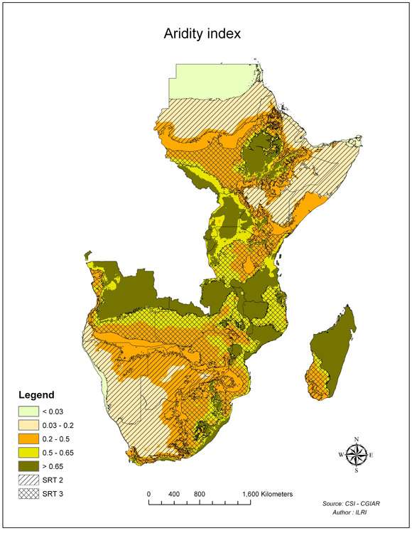
Aridity index
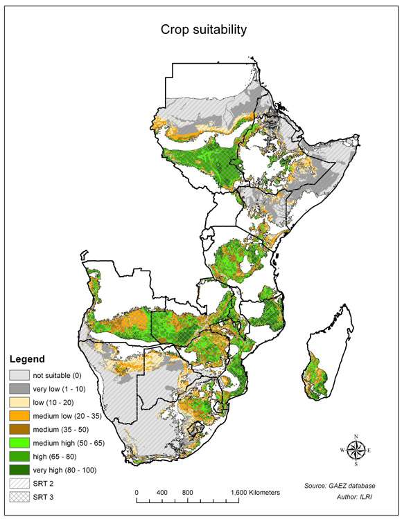
Crop suitability
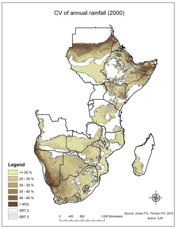
CV of annual rainfall (2000)
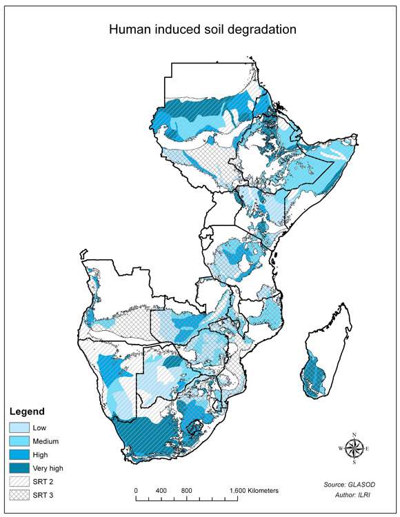
Human induced soil degradation
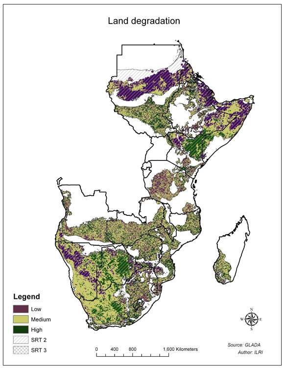
Land degradation
Landuse / Landcover
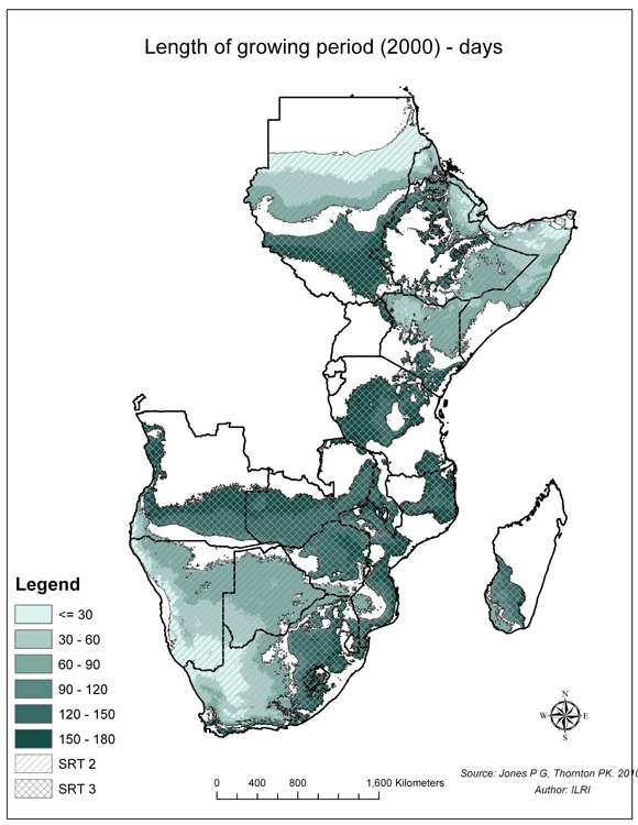
Length of growing period (2000) - days
Number of people living on less than 2 dollars a day
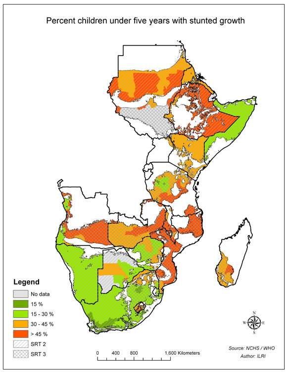
Percent children under five years with stunted growth
Percent underweight children below five years
Select country...ArmeniaAfghanistanAlbaniaAlgeriaAmerican SamoaAndorraAngolaAntigua and BarbudaArgentinaAustraliaAustriaBahamasBahrainBarbadosBangladeshBermudaBhutanBoliviaBotswanaBrazilArubaBelizeBritish Indian Ocean TerSolomon IslandsBrunei DarussalamBulgariaMyanmarBurundiAntarcticaBouvet IslandCameroonCanadaCape VerdeCayman IslandCentral African RepublicSri LankaChadChileChina, MainlandChristmas IslandCocos IslandsColombiaComorosCongo, Republic ofCook IslandsCosta RicaCubaCyprusAzerbaijan, Republic ofBeninDenmarkDominicaDominican RepublicBelarusEcuadorEgyptEl SalvadorEquatorial GuineaEstoniaFaeroe IslandsFalkland IslandsFiji IslandsFinlandFranceFrench GuianaFrench PolynesiaFrench South TerrDjiboutiGeorgiaGabonGambiaGaza StripGermanyBosnia and HerzegovinaGhanaGibraltarKiribatiGreeceGreenlandGrenadaGuadeloupeGuamGuatemalaGuineaGuyanaHeard and McDonald IsHaitiHondurasHungaryCroatiaIcelandIndiaIndonesiaIran, Islamic Rep ofIraqIrelandIsraelItalyIvory CoastKazakhstanJamaicaJapanJordanKyrgyzstanKenyaCambodiaKorea, Dem People's RepKorea, Republic ofKuwaitLatviaLaosLebanonLesothoLiberiaLibyan Arab JamahiriyaLiechtenstenLithuaniaMarshall IslandMadagascarMalawiMalaysiaMaldivesMaliMaltaMartiniqueMauritaniaMauritiusMexicoMidway IslandsMonacoMongoliaMontserratMoroccoMozambiqueMicronesia,Fed States ofMoldova, Republic ofNamibiaNauruNepalNetherlandsNeth AntillesNewCaledoniaMacedoniaVanuatuNew ZealandNicaraguaNigerNigeriaNiueNorfolk IslandNorwayNorthern Mariana IsPakistanPanamaCzech RepublicPapua New GuineaParaguayPeruPhilippinesPitcairn IslandsPolandPortugalGuinea-BissauEast TimorPuerto RicoEritreaQatarZimbabweReunionRomaniaRwandaRussian FederationSaint HelenaSaint Kitts and NevisSaint LuciaSaint Pierre & MiquelonSaint Vincent/GrenadinesSan MarinoSao Tome and PrincipeSaudi ArabiaSenegalSeychellesSierra LeoneSloveniaSlovakiaSingaporeSomaliaSouth AfricaSpainWestern SaharaSudanSurinameTajikistanSwazilandSwedenSwitzerlandSyrian Arab RepublicTurkmenistanChina, Taiwan Prov ofTanzania, United Rep ofThailandTogoTokelauTongaTrinidad and TobagoOmanTunisiaTurkeyTurks and Caicos IsUnited Arab EmiratesUgandaTuvaluUnited KingdomUkraineUnited States of AmericaUS Minor Outlying IsBurkina FasoUruguayUzbekistanVenezuelaViet NamEthiopiaBritish Virgin IslandUS Virgin IslandsWake IslandWallis and Futuna IsSamoaWest BankYemenCongo, Dem Republic ofZambiaBelgiumLuxembourgAnguillaSvalbard IsIsle of ManMayotteSouthGeorgia/Sandwich IsWestern EuropeIntergvt Author DevpmentNorth Western AfricaWestern AfricaCentral AfricaEastern AfricaSouthern AfricaLatin Amer & CaribbeanCentral AmericaCaribbeanSouth AmericaNear EastNear East in AfricaNear East in AsiaFar EastSouth AsiaEast & South East AsiaNear East and North AfricaEastern EuropeEuropeAsiaAfricaLatin AmericaSerbiaMontenegroSouth of SaharaNorth AfricaEurope, Non-EU CountriesNorth AmericaUSSR, Former Area ofArctic SeaAtlantic, NorthwestAtlantic, NortheastAtlantic, Western CentralAtlantic, Eastern CentralMediterran and Black SeaAtlantic, SouthwestAtlantic, SoutheastAtlantic, AntarcticIndian Ocean, WesternIndian Ocean, EasternIndian Ocean, AntarcticPacific, NorthwestPacific, NortheastPacific, Western CentralPacific, Eastern CentralPacific, SouthwestPacific, SoutheastPacific, AntarcticAll fishing areasWorld
Africa Asia Australia and Oceania Central America and the Caribbean Europe Middle East and North Africa North America South America
login failed
Message Body Goes Here
Failed


")


 - days")


