


Geoinformatics Solutions for Integrated Agro-ecosystems Research
GIS Data
Maps in: West African Sahel and Dry Savannas


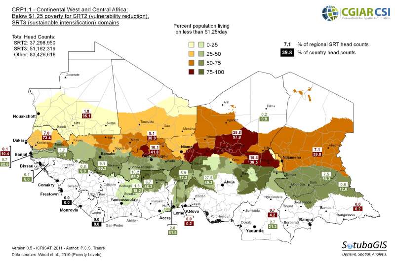
SRT extent
Procedure. Load Aridity Index (AI) raster. Clip for continental WCA extent using Data Management Tools, Raster, Raster Processing, Clip. Reclassify AI values to NoData (NoData, 5-300, 6,500-33,550), 2 (300-3,500), 3 (3,500-6,500) using Spatial Analyst Tools, Reclass, Reclassify. Project country limits and SRT polygons from Geographical Coordinates to Albers Equal Area Conic to allow computation of areas in km2 with Data Management Tools, Projections and Transformations, Feature, Project. Extract SRT2 and SRT3 area statistics per country with Spatial Analyst Tools, Zonal, Tabulate Area.
Regional analysis. Mali, Chad, Niger and Nigeria collectively hold 2/3 of the CRP1.1 domain area (SRT2+SRT3) for the region. Mali, Niger, Chad and Mauritania contain 85% of the regional SRT2 area. 60% of the SRT3 area falls within Nigeria, Chad, Mali and the Central African Republic.
Country analysis. Relative to national area, CRP1.1 covers the entirety of Burkina Faso, the Gambia and Senegal. Liberia and Sierra Leone are not CRP1.1 intervention countries. Leading SRT2 countries are Senegal, Mali, Niger, Mauritania. Leading SRT3 countries are Benin, the Gambia, Burkina Faso, Togo.
Metadataclose[x]
SRT extent
Procedure. Load Aridity Index (AI) raster. Clip for continental WCA extent using Data Management Tools, Raster, Raster Processing, Clip. Reclassify AI values to NoData (NoData, 5-300, 6,500-33,550), 2 (300-3,500), 3 (3,500-6,500) using Spatial Analyst Tools, Reclass, Reclassify. Project country limits and SRT polygons from Geographical Coordinates to Albers Equal Area Conic to allow computation of areas in km2 with Data Management Tools, Projections and Transformations, Feature, Project. Extract SRT2 and SRT3 area statistics per country with Spatial Analyst Tools, Zonal, Tabulate Area.
Regional analysis. Mali, Chad, Niger and Nigeria collectively hold 2/3 of the CRP1.1 domain area (SRT2+SRT3) for the region. Mali, Niger, Chad and Mauritania contain 85% of the regional SRT2 area. 60% of the SRT3 area falls within Nigeria, Chad, Mali and the Central African Republic.
Country analysis. Relative to national area, CRP1.1 covers the entirety of Burkina Faso, the Gambia and Senegal. Liberia and Sierra Leone are not CRP1.1 intervention countries. Leading SRT2 countries are Senegal, Mali, Niger, Mauritania. Leading SRT3 countries are Benin, the Gambia, Burkina Faso, Togo.