


Geoinformatics Solutions for Integrated Agro-ecosystems Research
GIS Data
Maps in: CACILM

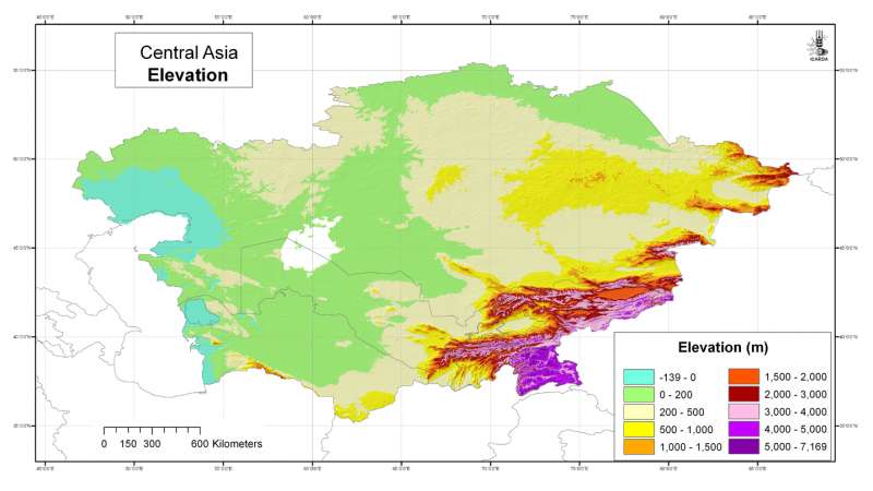
Central Asia: elevation
Elevation grid for Central Asia at 30 arc-second ( about 1 km) resolution derived from the global GTOPO30 grid
Metadataclose[x]
Central Asia: elevation
General-purpose use for hydrological or climatological applications and terrain studies
Elevation grid for Central Asia at 30 arc-second ( about 1 km) resolution derived from the global GTOPO30 grid
International Center for Agricultural Research in the Dry Areas (ICARDA)
2008
elevation, DEM, GTOPO30, digital elevation model
Central Asia, Tajikistan, Turkmenistan, Kazakhstan, Uzbekistan, Kyrgyzstan
46.491856
87.308522
55.432761
35.141094
D_WGS_1984
WGS_1984
6378137.000000
298.257224

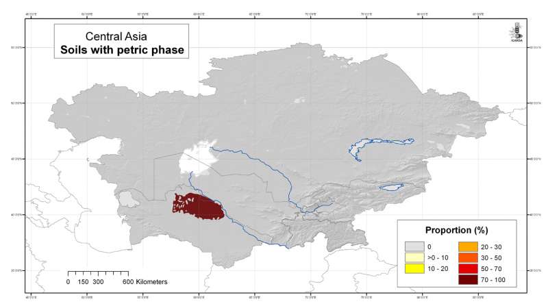
Central Asia: indurated soils with petric phase
Likelihood of the occurrence of soils with a petric phase in Central Asia at 30 arc-second ( about 1 km) resolution, derived from the FAO Soil Map of the World
Metadataclose[x]
Central Asia: indurated soils with petric phase
Derived soil properties give an indication of soil management properties and are useful for biodiversity assesment
Likelihood of the occurrence of soils with a petric phase in Central Asia at 30 arc-second ( about 1 km) resolution, derived from the FAO Soil Map of the World
International Center for Agricultural Research in the Dry Areas (ICARDA)
2008
soils, FAO, indurated soils, ironstone, petric phase, plinthite
Central Asia, Tajikistan, Turkmenistan, Kazakhstan, Uzbekistan, Kyrgyzstan
46.491856
87.308524
55.432762
35.141094
D_WGS_1984
WGS_1984
6378137.000000
298.257224

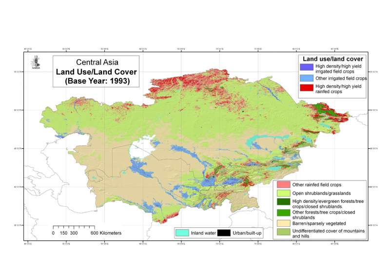
Central Asia: land use/land cover base year 1993
Land use/land cover classes for Central Asia at 30 arc-second ( about 1 km) resolution, base year 1993
Metadataclose[x]
Central Asia: land use/land cover base year 1993
To map land use/land cover using a simple but reliable classification system
Land use/land cover classes for Central Asia at 30 arc-second ( about 1 km) resolution, base year 1993
International Center for Agricultural Research in the Dry Areas (ICARDA)
2008
land use, land cover, AVHRR, remote sensing
Central Asia, Tajikistan, Turkmenistan, Kazakhstan, Uzbekistan, Kyrgyzstan
46.491856
87.308524
55.424429
35.141094
D_WGS_1984
WGS_1984
6378137.000000
298.257224
")
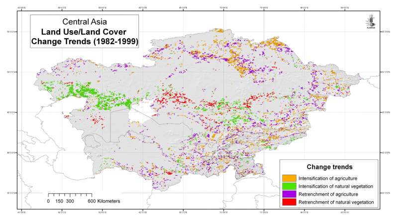
Central Asia: land use/land cover change trends (1982-1999)
Land use/land cover change trends for Central Asia at 4 arc-minute ( about 8 km) resolution
Metadataclose[x]
Central Asia: land use/land cover change trends (1982-1999)
To map areas of land use/land cover change and stability in the period 1982-1999
Land use/land cover change trends for Central Asia at 4 arc-minute ( about 8 km) resolution
International Center for Agricultural Research in the Dry Areas (ICARDA)
2008
land use change, land cover change, AVHRR, remote sensing, land degradation
Central Asia, Tajikistan, Turkmenistan, Kazakhstan, Uzbekistan, Kyrgyzstan
46.491856
87.292060
55.407862
35.141094
D_WGS_1984
WGS_1984
6378137.000000
298.257224

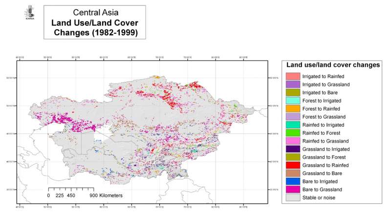
Central Asia: land use/land cover changes 1982-1999
Land use/land cover change classes for Central Asia at 4 arc-minute ( about 8 km) resolution
Metadataclose[x]
Central Asia: land use/land cover changes 1982-1999
To map areas of land use/land cover change and stability in the period 1982-1999
Land use/land cover change classes for Central Asia at 4 arc-minute ( about 8 km) resolution
International Center for Agricultural Research in the Dry Areas (ICARDA)
2008
land use, land cover, AVHRR, remote sensing, land degradation
Central Asia, Tajikistan, Turkmenistan, Kazakhstan, Uzbekistan, Kyrgyzstan
46.491856
87.292060
55.407862
35.141094
D_WGS_1984
WGS_1984
6378137.000000
298.257224

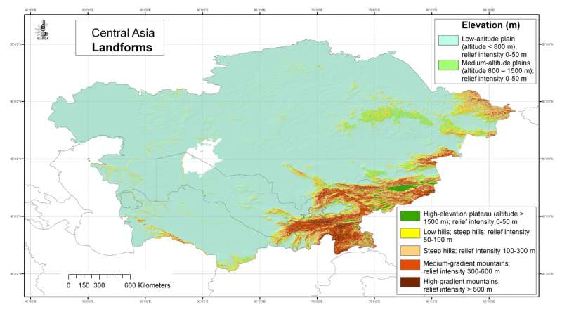
Central Asia: landforms
Landforms of Central Asia at 30 arc-second ( about 1 km) resolution, derived from the global GTOPO30 grid by creating 7 classes
Metadataclose[x]
Central Asia: landforms
Landforms are used to define agroecological zones
Landforms of Central Asia at 30 arc-second ( about 1 km) resolution, derived from the global GTOPO30 grid by creating 7 classes
International Center for Agricultural Research in the Dry Areas (ICARDA)
2008
elevation, DEM, GTOPO30, digital elevation model, landforms, relief
Central Asia, Tajikistan, Turkmenistan, Kazakhstan, Uzbekistan, Kyrgyzstan
46.491856
87.308524
55.432762
35.141094
D_WGS_1984
WGS_1984
6378137.000000
298.257224

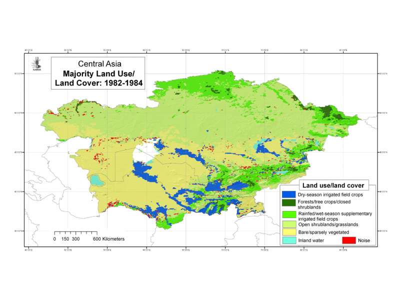
Central Asia: Majority land use/land cover during the period 1982-84
Majority land use/land cover in Central Asia during the period 1982-84 at 4 arc-minute ( about 8 km) resolution.
Metadataclose[x]
Central Asia: Majority land use/land cover during the period 1982-84
To map areas of land use/land cover change and stability in the period 1982-1999
Majority land use/land cover in Central Asia during the period 1982-84 at 4 arc-minute ( about 8 km) resolution.
International Center for Agricultural Research in the Dry Areas (ICARDA)
2008
land use, land cover, AVHRR, remote sensing, land degradation
Central Asia, Tajikistan, Turkmenistan, Kazakhstan, Uzbekistan, Kyrgyzstan
46.491856
87.292060
55.407862
35.141094
D_WGS_1984
WGS_1984
6378137.000000
298.257224

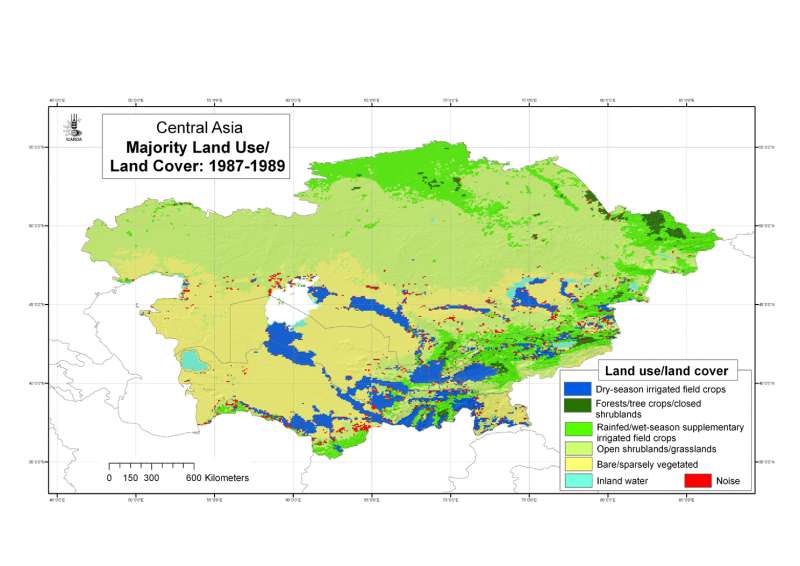
Central Asia: Majority land use/land cover during the period 1987-89
Majority land use/land cover in Central Asia during the period 1987-89 at 4 arc-minute ( about 8 km) resolution.
Metadataclose[x]
Central Asia: Majority land use/land cover during the period 1987-89
To map areas of land use/land cover change and stability in the period 1982-1999
Majority land use/land cover in Central Asia during the period 1987-89 at 4 arc-minute ( about 8 km) resolution.
International Center for Agricultural Research in the Dry Areas (ICARDA)
2008
land use, land cover, AVHRR, remote sensing, land degradation
Central Asia, Tajikistan, Turkmenistan, Kazakhstan, Uzbekistan, Kyrgyzstan
46.491856
87.292060
55.407862
35.141094
D_WGS_1984
WGS_1984
6378137.000000
298.257224

Central Asia: Majority land use/land cover during the period 1992-94
Majority land use/land cover in Central Asia during the period 1992-94 at 4 arc-minute ( about 8 km) resolution.
Metadataclose[x]
Central Asia: Majority land use/land cover during the period 1992-94
To map areas of land use/land cover change and stability in the period 1982-1999
Majority land use/land cover in Central Asia during the period 1992-94 at 4 arc-minute ( about 8 km) resolution.
International Center for Agricultural Research in the Dry Areas (ICARDA)
2008
land use, land cover, AVHRR, remote sensing, land degradation
Central Asia, Tajikistan, Turkmenistan, Kazakhstan, Uzbekistan, Kyrgyzstan
46.491856
87.292060
55.407862
35.141094
D_WGS_1984
WGS_1984
6378137.000000
298.257224

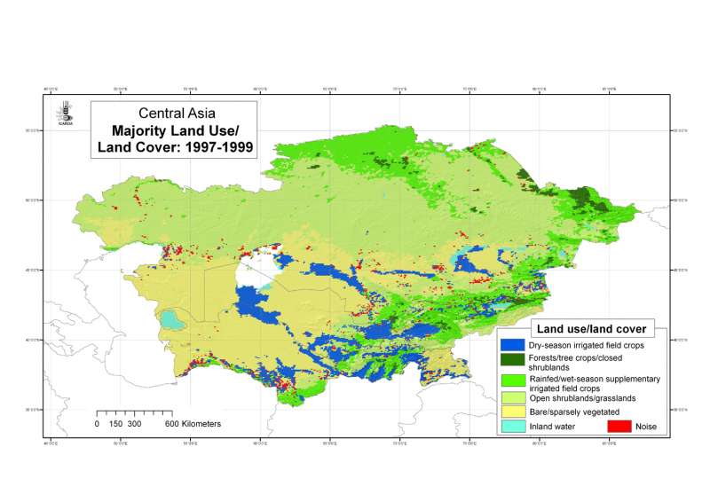
Central Asia: Majority land use/land cover during the period 1997-99
Majority land use/land cover in Central Asia during the period 1997-99 at 4 arc-minute ( about 8 km) resolution.
Metadataclose[x]
Central Asia: Majority land use/land cover during the period 1997-99
To map areas of land use/land cover change and stability in the period 1982-1999
Majority land use/land cover in Central Asia during the period 1997-99 at 4 arc-minute ( about 8 km) resolution.
International Center for Agricultural Research in the Dry Areas (ICARDA)
2008
land use, land cover, AVHRR, remote sensing, land degradation
Central Asia, Tajikistan, Turkmenistan, Kazakhstan, Uzbekistan, Kyrgyzstan
46.491856
87.292060
55.407862
35.141094
D_WGS_1984
WGS_1984
6378137.000000
298.257224