


Geoinformatics Solutions for Integrated Agro-ecosystems Research
GIS Data
Maps in: Climate
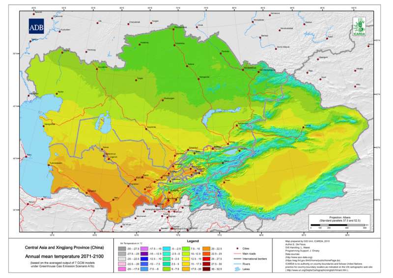
 Annual mean temperature 2071-2100 A1b Scenario")
Central Asia and Xingjiang Province (China) Annual mean temperature 2071-2100 A1b Scenario
Mean annual temperature 2071-2100 (based on the averaged output of 7 GCM models under Greenhouse Gas Emission Scenario A1b)
Metadataclose[x]
Central Asia and Xingjiang Province (China) Annual mean temperature 2071-2100 A1b Scenario
An input layer to create the map of Changes in Annual mean temperature of Central Asia
Mean annual temperature 2071-2100 (based on the averaged output of 7 GCM models under Greenhouse Gas Emission Scenario A1b)
International Center for Agricultural Research in the Dry Areas (ICARDA)
2010
Tajikistan, Turkmenistan, Kazakhstan, Uzbekistan, Kyrgyzstan, Xingjiang Province
51.218469686
103.047567786
52.69812595
32.817056204
D_WGS_1984
WGS_1984
6378137.000000
298.257224
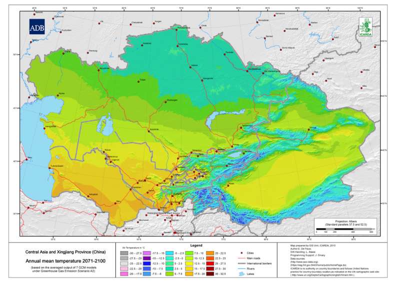
 Annual mean temperature 2071-2100 A2 Scenario")
Central Asia and Xingjiang Province (China) Annual mean temperature 2071-2100 A2 Scenario
Mean annual temperature 2071-2100 (based on the averaged output of 7 GCM models under Greenhouse Gas Emission Scenario A2)
Metadataclose[x]
Central Asia and Xingjiang Province (China) Annual mean temperature 2071-2100 A2 Scenario
An input layer to create the map of Changes in Annual mean temperature of Central Asia
Mean annual temperature 2071-2100 (based on the averaged output of 7 GCM models under Greenhouse Gas Emission Scenario A2)
International Center for Agricultural Research in the Dry Areas (ICARDA)
2010
Tajikistan, Turkmenistan, Kazakhstan, Uzbekistan, Kyrgyzstan, Xingjiang Province
51.218469686
103.047567786
52.69812595
32.817056204
D_WGS_1984
WGS_1984
6378137.000000
298.257224
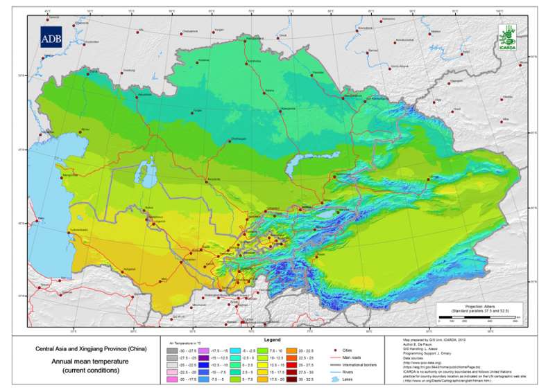
 Annual mean temperature Current")
Central Asia and Xingjiang Province (China) Annual mean temperature Current
Mean annual temperature grid for Central Asia and Xingjiang Province (China) at 30 arc-second ( about 1 km) resolution
Metadataclose[x]
Central Asia and Xingjiang Province (China) Annual mean temperature Current
An input layer to create the map of agroclimatic zones and the map of the Changes in Annual mean temperature of Central Asia
Mean annual temperature grid for Central Asia and Xingjiang Province (China) at 30 arc-second ( about 1 km) resolution
International Center for Agricultural Research in the Dry Areas (ICARDA)
2010
Tajikistan, Turkmenistan, Kazakhstan, Uzbekistan, Kyrgyzstan, Xingjiang Province
51.218469686
103.047567786
52.69812595
32.817056204
D_WGS_1984
WGS_1984
6378137.000000
298.257224
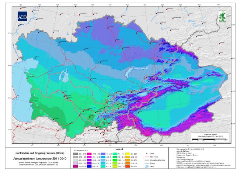
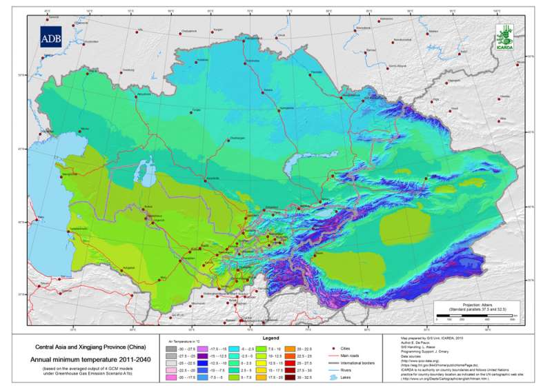
 Annual minimum temperature 2011-2040 A1b Scenario")
Central Asia and Xingjiang Province (China) Annual minimum temperature 2011-2040 A1b Scenario
Mean annual minimum temperature 2011-2040 (based on the averaged output of 7 GCM models under Greenhouse Gas Emission Scenario A1b)
Metadataclose[x]
Central Asia and Xingjiang Province (China) Annual minimum temperature 2011-2040 A1b Scenario
An input layer to create the map of the Changes in the Annual minimum temperature of Central Asia
Mean annual minimum temperature 2011-2040 (based on the averaged output of 7 GCM models under Greenhouse Gas Emission Scenario A1b)
International Center for Agricultural Research in the Dry Areas (ICARDA)
2010
Tajikistan, Turkmenistan, Kazakhstan, Uzbekistan, Kyrgyzstan, Xingjiang Province
51.218469686
103.047567786
52.69812595
32.817056204
D_WGS_1984
WGS_1984
6378137.000000
298.257224
 Annual minimum temperature 2011-2040 A2 Scenario")
Central Asia and Xingjiang Province (China) Annual minimum temperature 2011-2040 A2 Scenario
Mean annual minimumtemperature 2011-2040 (based on the averaged output of 7 GCM models under Greenhouse Gas Emission Scenario A2)
Metadataclose[x]
Central Asia and Xingjiang Province (China) Annual minimum temperature 2011-2040 A2 Scenario
An input layer to create the map of the Changes in the Annual minimum temperature of Central Asia
Mean annual minimumtemperature 2011-2040 (based on the averaged output of 7 GCM models under Greenhouse Gas Emission Scenario A2)
International Center for Agricultural Research in the Dry Areas (ICARDA)
2010
Tajikistan, Turkmenistan, Kazakhstan, Uzbekistan, Kyrgyzstan, Xingjiang Province
51.218469686
103.047567786
52.69812595
32.817056204
D_WGS_1984
WGS_1984
6378137.000000
298.257224
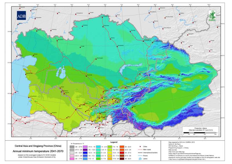
 Annual minimum temperature 2041-2070 A1b Scenario")
Central Asia and Xingjiang Province (China) Annual minimum temperature 2041-2070 A1b Scenario
Mean annual minimumtemperature 2041-2070 (based on the averaged output of 7 GCM models under Greenhouse Gas Emission Scenario A1b)
Metadataclose[x]
Central Asia and Xingjiang Province (China) Annual minimum temperature 2041-2070 A1b Scenario
An input layer to create the map of the Changes in the Annual minimum temperature of Central Asia
Mean annual minimumtemperature 2041-2070 (based on the averaged output of 7 GCM models under Greenhouse Gas Emission Scenario A1b)
International Center for Agricultural Research in the Dry Areas (ICARDA)
2010
Tajikistan, Turkmenistan, Kazakhstan, Uzbekistan, Kyrgyzstan, Xingjiang Province
51.218469686
103.047567786
52.69812595
32.817056204
D_WGS_1984
WGS_1984
6378137.000000
298.257224
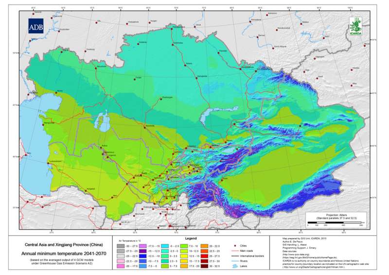
 Annual minimum temperature 2041-2070 A2 Scenario")
Central Asia and Xingjiang Province (China) Annual minimum temperature 2041-2070 A2 Scenario
Mean annual minimumtemperature 2041-2070 (based on the averaged output of 7 GCM models under Greenhouse Gas Emission Scenario A2)
Metadataclose[x]
Central Asia and Xingjiang Province (China) Annual minimum temperature 2041-2070 A2 Scenario
An input layer to create the map of the Changes in the Annual minimum temperature of Central Asia
Mean annual minimumtemperature 2041-2070 (based on the averaged output of 7 GCM models under Greenhouse Gas Emission Scenario A2)
International Center for Agricultural Research in the Dry Areas (ICARDA)
2010
Tajikistan, Turkmenistan, Kazakhstan, Uzbekistan, Kyrgyzstan, Xingjiang Province
51.218469686
103.047567786
52.69812595
32.817056204
D_WGS_1984
WGS_1984
6378137.000000
298.257224
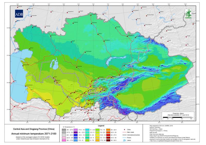
 Annual minimum temperature 2071-2100 A1b Scenario")
Central Asia and Xingjiang Province (China) Annual minimum temperature 2071-2100 A1b Scenario
Mean annual minimumtemperature 2071-2100 (based on the averaged output of 7 GCM models under Greenhouse Gas Emission Scenario A1b)
Metadataclose[x]
Central Asia and Xingjiang Province (China) Annual minimum temperature 2071-2100 A1b Scenario
An input layer to create the map of the Changes in the Annual minimum temperature of Central Asia
Mean annual minimumtemperature 2071-2100 (based on the averaged output of 7 GCM models under Greenhouse Gas Emission Scenario A1b)
International Center for Agricultural Research in the Dry Areas (ICARDA)
2010
Tajikistan, Turkmenistan, Kazakhstan, Uzbekistan, Kyrgyzstan, Xingjiang Province
51.218469686
103.047567786
52.69812595
32.817056204
D_WGS_1984
WGS_1984
6378137.000000
298.257224
 Annual minimum temperature 2071-2100 A2 Scenario")
Central Asia and Xingjiang Province (China) Annual minimum temperature 2071-2100 A2 Scenario
Mean annual minimumtemperature 2071-2100 (based on the averaged output of 7 GCM models under Greenhouse Gas Emission Scenario A2)
Metadataclose[x]
Central Asia and Xingjiang Province (China) Annual minimum temperature 2071-2100 A2 Scenario
An input layer to create the map of the Changes in the Annual minimum temperature of Central Asia
Mean annual minimumtemperature 2071-2100 (based on the averaged output of 7 GCM models under Greenhouse Gas Emission Scenario A2)
International Center for Agricultural Research in the Dry Areas (ICARDA)
2010
Tajikistan, Turkmenistan, Kazakhstan, Uzbekistan, Kyrgyzstan, Xingjiang Province
51.218469686
103.047567786
52.69812595
32.817056204
D_WGS_1984
WGS_1984
6378137.000000
298.257224
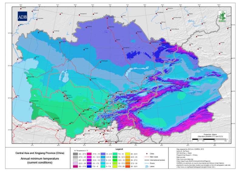
 Annual minimum temperature Current")
Central Asia and Xingjiang Province (China) Annual minimum temperature Current
Mean annual Temperature of the coldest month for Central Asia and Xingjiang Province (China) at 30 arc-second ( about 1 km) resolution
Metadataclose[x]
Central Asia and Xingjiang Province (China) Annual minimum temperature Current
An input layer to create the map of agroclimatic zones and the map of the Changes in Annual mean temperature of Central Asia
Mean annual Temperature of the coldest month for Central Asia and Xingjiang Province (China) at 30 arc-second ( about 1 km) resolution
International Center for Agricultural Research in the Dry Areas (ICARDA)
2010
Tajikistan, Turkmenistan, Kazakhstan, Uzbekistan, Kyrgyzstan, Xingjiang Province
51.218469686
103.047567786
52.69812595
32.817056204
D_WGS_1984
WGS_1984
6378137.000000
298.257224