


Geoinformatics Solutions for Integrated Agro-ecosystems Research

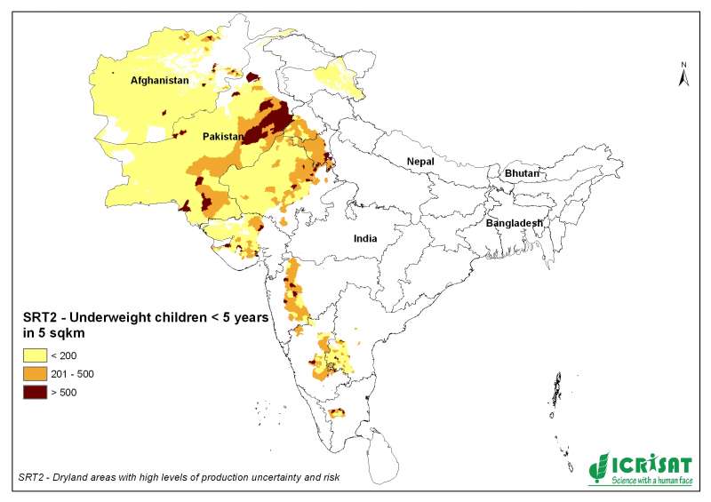
SRT2-type drylands: malnutrition/stunting data
The Global Subnational Prevalence of Child Malnutrition dataset
consists of estimates of the percentage of children with
weight-for-age z-scores that are more than two standard deviations
below the median of the NCHS/CDC/WHO International Reference
Population. Data are reported for the most recent year with
subnational information available at the time of development. The
data products include a shapefile (vector data) of percentage rates,
grids (raster data) of rates (per thousand in order to preserve
precision in integer format), the number of children under five (the
rate denominator), and the number of underweight children under five
(the rate numerator), and a tabular dataset of the same and
associated data. This dataset is produced by the Columbia University
Center for International Earth Science Information Network
(CIESIN).
The global data sets include two proxy poverty measurements: Infant Mortality Rates and Malnutrition (underweight children), all
translated to a common quarter-degree grid. A quarter-degree grid
cell is approximately 770 square kilometers (300 square miles) at
the equator, and progressively less at higher latitudes.
Originator: Center for International Earth Science
Information Network (CIESIN), Columbia University
Publication Date: 2005
Title: Poverty Mapping Project: Global Subnational Prevalence of Child Malnutrition
Geospatial Data Presentation Form: raster digital data, vector digital data, tabular digital data, map
Publication Information:
Publication Date: 2005
Title: Poverty Mapping Project: Global Subnational Prevalence of Child Malnutrition
Geospatial Data Presentation Form: raster digital data, vector digital data, tabular digital data, map
Publication Information:
Publication Place: Palisades, NY
Publisher: CIESIN, Columbia University
Publisher: CIESIN, Columbia University