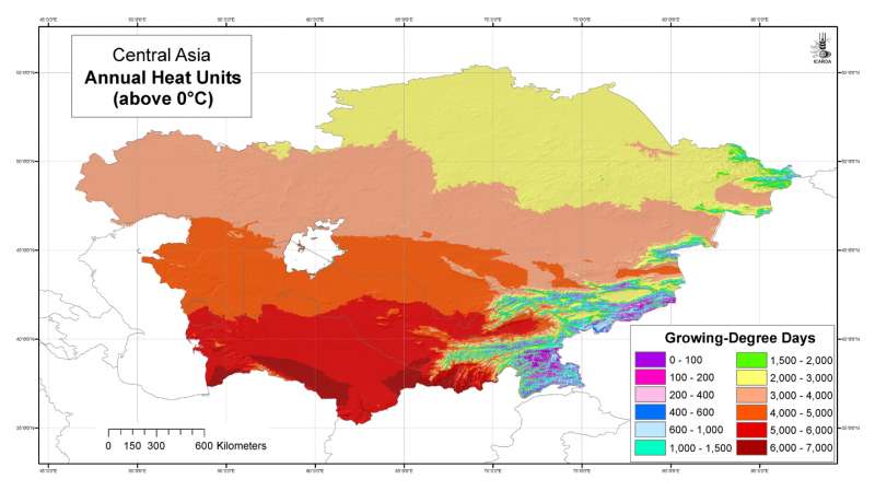
Annual Heat Units grid for Central Asia at 30 arc-second ( about 1 km) resolution
OriginatorInternational Center for Agricultural Research in the Dry Areas (ICARDA)
Publication Date2008
TitleCentral Asia: Annual Heat Units (above 0���������������°C)
Geospatial Data Presentation Formraster digital data
Other Citation DetailsDe Pauw, E. 2008. ICARDA Regional GIS Datasets for Central Asia: Explanatory Notes. GIS Unit Technical Bulletin. International Center for Agricultural Research in the Dry Areas (ICARDA), Aleppo, Syria.
Online Linkagehttp://gu.icarda.org/geocms/public/en/cms/metadata/index/80/Central+Asia%3A+Annual+Heat+Units+%28above+0%C3%3F%C3%3F%C3%3F%C3%3F%C3%3F%C3%3F%C3%3F%C3%3F%C3%3F%C3%3F%C3%3F%C3%3F%C3%3F%C3%3F%C3%3F%C3%C2C%29+++++++++++++++++/
AbstractAnnual Heat Units grid for Central Asia at 30 arc-second ( about 1 km) resolution
PurposeDeveloped for geospatial applications that require location-specific climatic information in places where no nearby climatic station exists
Supplemental InformationUnits are in growing degree days (���������������°C.days)
Beginning Date1961
Ending Date1987
Currentness Referenceground condition
ProgressComplete
Maintenance and Update FrequencyIrregular
West Bounding Coordinate46.491856
East Bounding Coordinate87.315223
North Bounding Coordinate55.431949
South Bounding Coordinate35.141094
Theme Keyword ThesaurusREQUIRED: Reference to a formally registered thesaurus or a similar authoritative source of theme keywords.
Theme Keywordclimate
Theme Keywordtemperature
Theme Keywordheat units
Theme Keywordgrowing degree days
Place KeywordCentral Asia
Place KeywordTajikistan
Place KeywordTurkmenistan
Place KeywordKazakhstan
Place KeywordUzbekistan
Place KeywordKyrgyzstan
Access ConstraintsOpen access policy: reproduction and distribution of this dataset is allowed subject to proper citation (see citation information)
Use ConstraintsFair use policy: commercialization of this dataset is not allowed. No constraints on use in applications, whether for commercial or non-profit.
Contact PersonICARDA, Geoinformatics Unit
Contact OrganizationICARDA
Contact PositionICARDA, Geoinformatics Unit
Contact Voice Telephone+963-21-2213433
Contact Voice Telephone+963-21-2169-2470
Contact Electronic Mail Addressicarda-gisu@cgiar.org
Browse Graphic File Namehttp://geonet.icarda.cgiar.org/geonetwork/data/regional/cacilm/Temp/thumbnail/Heat%20Units_A3.jpg
Browse Graphic File Descriptioncreated by map export from a ArcGIS project using A3 size and 90 dpi
Browse Graphic File TypeJPEG
Browse Graphic File Namehttp://geonet.icarda.cgiar.org/geonetwork/data/regional/cacilm/Temp/map/Heat%20Units_A3.tif
Browse Graphic File Descriptioncreated by map export from a ArcGIS project using A3 size and 300 dpi
Browse Graphic File TypeTIFF
Data Set CreditBashar Nseir, Layal Atassi, and Fawaz Tulaymat have been involved at one time or another in the GIS processing of this and similar datasets of the GIS Unit
Security ClassificationUnclassified
OriginatorRobert Hijmans
TitleWORLDCLIM
Other Citation DetailsRobert J. Hijmans, Susan E. Cameron, Juan L. Parra, Peter G. Jones and Andy Jarvis. 2005. Very high resolution interpolated climate surfaces for global land areas. Int. J. Climatol. 25: 1965-1978 (2005).
Online Linkagehttp://www.worldclim.org
Attribute Accuracy ReportData values for all stations have been checked for plausibility
Horizontal Positional Accuracy ReportGeographical accuracy of all stations has been checked
Vertical Positional Accuracy ReportElevation accuracy for all stations has been checked against GTOPO30 DEM
OriginatorUzbekistan HydroMetService
TitleMonthly Reference Book on Meteorology Vol 19: Uzbekistan 1961-1987
Source Citation AbbreviationMonthly Reference books on Meteorology
OriginatorTurkmenistan HydroMetService
TitleMonthly Reference Book on Meteorology Vol 30: Turkmenistan 1961-1987
OriginatorTajikistan HydroMetService
TitleMonthly Reference Book on Meteorology Vol 31: Tajikistan 1961-1987
OriginatorKyrgyzstan HydroMetService
TitleMonthly Reference Book on Meteorology Vol 32: Kyrgyzstan 1961-1987
OriginatorKazakhstan HydroMetService
TitleMonthly Reference Book on Meteorology Vol 18: Kazakhstan 1967-1987
Process DescriptionCalculated from the monthly <temp> grids by multiplying for each month the mean monthly temperature with the number of days in the month and adding these monthly values for the entire year. If the mean monthly temperature is below zero, the heat unit total for that month is zero.
Direct Spatial Reference MethodRaster
Raster Object TypeGrid Cell
Row Count2435
Column Count4899
Vertical Count1
Latitude Resolution0.000000
Longitude Resolution0.000000
Geographic Coordinate UnitsDecimal degrees
Planar Coordinate Encoding Methodrow and column
Abscissa Resolution0.008333
Ordinate Resolution0.008333
Horizontal Datum NameD_WGS_1984
Ellipsoid NameWGS_1984
Semi-major Axis6378137.000000
Denominator of Flattening Ratio298.257224
Contact PersonEddy De Pauw
Contact PositionHead GIS Unit
Contact Electronic Mail Addresse.de-pauw@cgiar.org
Resource DescriptionDownloadable Data
Distribution LiabilityICARDA declines all responsibility for errors or deficiencies in the database or in the documentation accompanying it, for maintenance or for updating the database. Users are however kindly requested to report any errors or deficiencies in this product to ICARDA.ICARDA is no authority on country boundaries and follows UN practice regarding country boundary location, as indicated on the United Nations Cartographic Website: http://www.un.org/Depts/Cartographic/english/htmain.htm
Transfer Size47.708
Technical PrerequisitesArcGIS, or ArcView with Spatial Analyst extension. Metadata can be read directly in ArcCatalog or in a Web browser using the HTML pages provided separately.
Metadata Date20090203
Contact PersonEddy DE PAUW
Contact OrganizationInternational Center for Agricultural Research in Dry Areas (ICARDA)
Contact PositionConsultant, Geoinformatics Unit
Address Typemailing address
AddressICARDA, P.O. Box 114/5055
CityBeirut
State or ProvinceBeirut
Postal CodeREQUIRED: The ZIP or other postal code of the address.
CountryLebanon
Contact Voice Telephone+963-2169-2470
Metadata Standard NameFGDC Content Standards for Digital Geospatial Metadata
Metadata Standard VersionFGDC-STD-001-1998
Metadata Time Conventionlocal time
Metadata Access ConstraintsNone
Metadata Use ConstraintsNone
Online Linkagehttp://www.esri.com/metadata/esriprof80.html
metprofESRI Metadata Profile
Select country...ArmeniaAfghanistanAlbaniaAlgeriaAmerican SamoaAndorraAngolaAntigua and BarbudaArgentinaAustraliaAustriaBahamasBahrainBarbadosBangladeshBermudaBhutanBoliviaBotswanaBrazilArubaBelizeBritish Indian Ocean TerSolomon IslandsBrunei DarussalamBulgariaMyanmarBurundiAntarcticaBouvet IslandCameroonCanadaCape VerdeCayman IslandCentral African RepublicSri LankaChadChileChina, MainlandChristmas IslandCocos IslandsColombiaComorosCongo, Republic ofCook IslandsCosta RicaCubaCyprusAzerbaijan, Republic ofBeninDenmarkDominicaDominican RepublicBelarusEcuadorEgyptEl SalvadorEquatorial GuineaEstoniaFaeroe IslandsFalkland IslandsFiji IslandsFinlandFranceFrench GuianaFrench PolynesiaFrench South TerrDjiboutiGeorgiaGabonGambiaGaza StripGermanyBosnia and HerzegovinaGhanaGibraltarKiribatiGreeceGreenlandGrenadaGuadeloupeGuamGuatemalaGuineaGuyanaHeard and McDonald IsHaitiHondurasHungaryCroatiaIcelandIndiaIndonesiaIran, Islamic Rep ofIraqIrelandIsraelItalyIvory CoastKazakhstanJamaicaJapanJordanKyrgyzstanKenyaCambodiaKorea, Dem People's RepKorea, Republic ofKuwaitLatviaLaosLebanonLesothoLiberiaLibyan Arab JamahiriyaLiechtenstenLithuaniaMarshall IslandMadagascarMalawiMalaysiaMaldivesMaliMaltaMartiniqueMauritaniaMauritiusMexicoMidway IslandsMonacoMongoliaMontserratMoroccoMozambiqueMicronesia,Fed States ofMoldova, Republic ofNamibiaNauruNepalNetherlandsNeth AntillesNewCaledoniaMacedoniaVanuatuNew ZealandNicaraguaNigerNigeriaNiueNorfolk IslandNorwayNorthern Mariana IsPakistanPanamaCzech RepublicPapua New GuineaParaguayPeruPhilippinesPitcairn IslandsPolandPortugalGuinea-BissauEast TimorPuerto RicoEritreaQatarZimbabweReunionRomaniaRwandaRussian FederationSaint HelenaSaint Kitts and NevisSaint LuciaSaint Pierre & MiquelonSaint Vincent/GrenadinesSan MarinoSao Tome and PrincipeSaudi ArabiaSenegalSeychellesSierra LeoneSloveniaSlovakiaSingaporeSomaliaSouth AfricaSpainWestern SaharaSudanSurinameTajikistanSwazilandSwedenSwitzerlandSyrian Arab RepublicTurkmenistanChina, Taiwan Prov ofTanzania, United Rep ofThailandTogoTokelauTongaTrinidad and TobagoOmanTunisiaTurkeyTurks and Caicos IsUnited Arab EmiratesUgandaTuvaluUnited KingdomUkraineUnited States of AmericaUS Minor Outlying IsBurkina FasoUruguayUzbekistanVenezuelaViet NamEthiopiaBritish Virgin IslandUS Virgin IslandsWake IslandWallis and Futuna IsSamoaWest BankYemenCongo, Dem Republic ofZambiaBelgiumLuxembourgAnguillaSvalbard IsIsle of ManMayotteSouthGeorgia/Sandwich IsWestern EuropeIntergvt Author DevpmentNorth Western AfricaWestern AfricaCentral AfricaEastern AfricaSouthern AfricaLatin Amer & CaribbeanCentral AmericaCaribbeanSouth AmericaNear EastNear East in AfricaNear East in AsiaFar EastSouth AsiaEast & South East AsiaNear East and North AfricaEastern EuropeEuropeAsiaAfricaLatin AmericaSerbiaMontenegroSouth of SaharaNorth AfricaEurope, Non-EU CountriesNorth AmericaUSSR, Former Area ofArctic SeaAtlantic, NorthwestAtlantic, NortheastAtlantic, Western CentralAtlantic, Eastern CentralMediterran and Black SeaAtlantic, SouthwestAtlantic, SoutheastAtlantic, AntarcticIndian Ocean, WesternIndian Ocean, EasternIndian Ocean, AntarcticPacific, NorthwestPacific, NortheastPacific, Western CentralPacific, Eastern CentralPacific, SouthwestPacific, SoutheastPacific, AntarcticAll fishing areasWorld
Africa Asia Australia and Oceania Central America and the Caribbean Europe Middle East and North Africa North America South America
login failed
Message Body Goes Here
Failed


")