


Geoinformatics Solutions for Integrated Agro-ecosystems Research
GIS Data
Global - Poverty
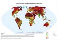
Global drylands and agriculture resource poverty
Agricultural resource poverty is a structural component of environmental poverty, which is principally determined by climatic, topographic and soil constraints, as well as lack of water resources for irrigation, where needed. This global map shows a quantified estimate of the constraints to agriculture as imposed by the biophysical environment, using an index approach, scaled to a range 0-100, with 100 expressing the highest degree of resource poverty. The map has been compiled as a synthesis of individual thematic resource poverty maps (climate, topography, soils and irrigation water resources).
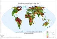
Global drylands and soil resource poverty
The Soil Resource Poverty Index is the percentage of each grid cell occupied by problem soils. Problem soils include the following categories: saline soils, soils with high sodium content, shallow soils, sandy soils, soils with very poor profile development, soils with severe soil structural and/or textural limitations, soils with severe acidity, infertility or Al-toxicity problems, wetland soils, acid sulphate soils.
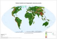
Global drylands and topographic resource poverty
Landscapes that are strongly dissected, i.e. with high elevation differences, contain little land with agricultural value. Where such land exists, it is mostly located in narrow, often disconnected and poorly accessible valleys, On the other hand, flat landforms (plains and plateaux) in general have little land with unsuitable topography. Of course, even in flat areas unsuitable soils or even rock outcrops may occur, but these can be identified from the soil maps and will result in a high Soil Resource Poverty Index . Given the strict separation between topographic and soil resources, the methodology does not allow double counting.
The Topographic Resource Poverty Index (TRPI) is the percentage of each grid cell with slopes above 15%.
For areas between 60⁰ N and 60⁰ S, TRPI is obtained from the SRTM DEM by first identifying those areas with slopes > 15%, followed by aggregation of the result raster to a cell size of SRTM30 DEM (0.008333 decimal degrees), using summation as aggregation technique.
For areas above 60⁰ N, SRTM data are not available and the TRPI was calculated by a relationship established between the TRPI and a low-resolution proxy indicator of slope, obtained from a 1-km DEM. The proxy indicator is the range, or the maximum elevation difference between neighbouring pixels, obtained from the global SRTM30 DEM. The range was for these areas converted into estimated values of TRPI by regression
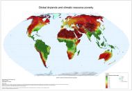
Global drylands and climatic resource poverty
The Climatic Resource Index (CRI) is an indicator of the climatic potential for biomass production. It is based on a combination of the annual growing-degree-days above 0°C and the annual aridity index, rescaled to values between 0 and 100. The index takes into consideration whether an area is irrigated or not, and to what extent. The Climatic Resource Poverty Index, shown in this map, is calculated as 100-CRI.