


Geoinformatics Solutions for Integrated Agro-ecosystems Research
Global drylands and topographic resource poverty
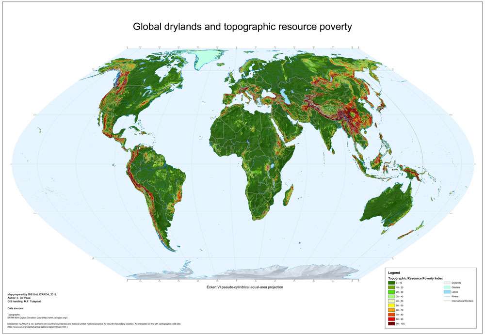
Landscapes that are strongly dissected, i.e. with high elevation differences, contain little land with agricultural value. Where such land exists, it is mostly located in narrow, often disconnected and poorly accessible valleys, On the other hand, flat landforms (plains and plateaux) in general have little land with unsuitable topography. Of course, even in flat areas unsuitable soils or even rock outcrops may occur, but these can be identified from the soil maps and will result in a high Soil Resource Poverty Index . Given the strict separation between topographic and soil resources, the methodology does not allow double counting.
The Topographic Resource Poverty Index (TRPI) is the percentage of each grid cell with slopes above 15%.
For areas between 60⁰ N and 60⁰ S, TRPI is obtained from the SRTM DEM by first identifying those areas with slopes > 15%, followed by aggregation of the result raster to a cell size of SRTM30 DEM (0.008333 decimal degrees), using summation as aggregation technique.
For areas above 60⁰ N, SRTM data are not available and the TRPI was calculated by a relationship established between the TRPI and a low-resolution proxy indicator of slope, obtained from a 1-km DEM. The proxy indicator is the range, or the maximum elevation difference between neighbouring pixels, obtained from the global SRTM30 DEM. The range was for these areas converted into estimated values of TRPI by regression
Author:
E. De Pauw
Institute:
ICARDA GIS unit
Decription:
Landscapes that are strongly dissected, i.e. with high elevation differences, contain little land with agricultural value. Where such land exists, it is mostly located in narrow, often disconnected and poorly accessible valleys, On the other hand, flat landforms (plains and plateaux) in general have little land with unsuitable topography. Of course, even in flat areas unsuitable soils or even rock outcrops may occur, but these can be identified from the soil maps and will result in a high Soil Resource Poverty Index . Given the strict separation between topographic and soil resources, the methodology does not allow double counting.
The Topographic Resource Poverty Index (TRPI) is the percentage of each grid cell with slopes above 15%.
For areas between 60⁰ N and 60⁰ S, TRPI is obtained from the SRTM DEM by first identifying those areas with slopes > 15%, followed by aggregation of the result raster to a cell size of SRTM30 DEM (0.008333 decimal degrees), using summation as aggregation technique.
For areas above 60⁰ N, SRTM data are not available and the TRPI was calculated by a relationship established between the TRPI and a low-resolution proxy indicator of slope, obtained from a 1-km DEM. The proxy indicator is the range, or the maximum elevation difference between neighbouring pixels, obtained from the global SRTM30 DEM. The range was for these areas converted into estimated values of TRPI by regression
Source Data:
SRTM 90m Digital Elevation Data (http://srtm.csi.cgiar.org/)
SRTM30 Digital Elevation Data (http://www.dgadv.com/srtm30/)