


Geoinformatics Solutions for Integrated Agro-ecosystems Research
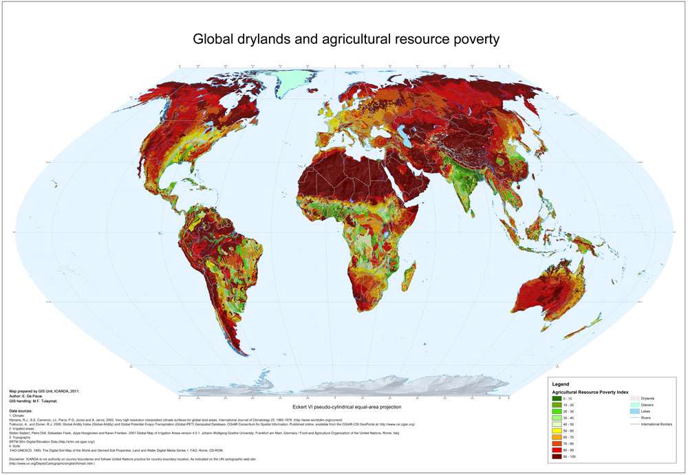
Global drylands and agriculture resource poverty
Agricultural resource poverty is a structural component of environmental poverty, which is principally determined by climatic, topographic and soil constraints, as well as lack of water resources for irrigation, where needed. This global map shows a quantified estimate of the constraints to agriculture as imposed by the biophysical environment, using an index approach, scaled to a range 0-100, with 100 expressing the highest degree of resource poverty. The map has been compiled as a synthesis of individual thematic resource poverty maps (climate, topography, soils and irrigation water resources).
Author:
E. De Pauw
Institute:
ICARDA GIS unit
Decription:
Agricultural resource poverty is a structural component of environmental poverty, which is principally determined by climatic, topographic and soil constraints, as well as lack of water resources for irrigation, where needed. This global map shows a quantified estimate of the constraints to agriculture as imposed by the biophysical environment, using an index approach, scaled to a range 0-100, with 100 expressing the highest degree of resource poverty. The map has been compiled as a synthesis of individual thematic resource poverty maps (climate, topography, soils and irrigation water resources).
The Global Agricultural Resource Poverty Index is the lowest of three resource poverty indices (Climatic Resource Poverty Index , Topographic Resource Poverty Index , Soil Resource Poverty Index .
Source Data:
Climate:
Hijmans, R.J., S.E. Cameron, J.L. Parra, P.G. Jones and A. Jarvis, 2005. Very high resolution interpolated climate surfaces for global land areas. International Journal of Climatology 25: 1965-1978. (http://www.worldclim.org/current)
Trabucco, A., and Zomer, R.J. 2009. Global Aridity Index (Global-Aridity) and Global Potential Evapo-Transpiration (Global-PET) Geospatial Database. CGIAR Consortium for Spatial Information.
Published online, available from the CGIAR-CSI GeoPortal at: http://www.csi.cgiar.org/ .
Irrigated areas: Stefan Siebert, Petra Döll, Sebastian Feick, Jippe Hoogeveen and Karen Frenken. 2007.Global Map of Irrigation Areas version 4.0.1. Johann Wolfgang Goethe University, Frankfurt am Main, Germany / Food and Agriculture Organization of the United Nations, Rome, Italy
Topography: SRTM 90m Digital Elevation Data (http://srtm.csi.cgiar.org/)
Soils: FAO-UNESCO. 1995. The Digital Soil Map of the World and Derived Soil Properties. Land and Water Digital Media Series 1. FAO, Rome. CD-ROM.