


Geoinformatics Solutions for Integrated Agro-ecosystems Research
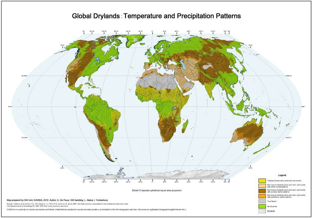
Global Drylands: Temperature and Precipitation Patterns
The drylands of the world show great diversity in their temperature characteristics and precipitation patterns. This map captures this diversity in a limited number of classes with the following characteristics:
NON-TROPICAL DRYLANDS
- Cold (< 10° C) to mild winters (10-20° C);
- Mild (10-20° C) to very warm (> 30° C) summers.;
- Moisture regime ranging from arid to semi-arid to sub-humid;
- Variable precipitation patterns;
- Cold is a general but variable constraint, depending on severity of the winters, requiring adaptation of plants and crops;
- Agricultural systems are dominated by non-tropical crops with low water requirements (wheat, barley)
With winter-rainfall patterns
Water needs of crops are lower as compared to tropical areas, therefore higher water use efficiency. C3-crops have a productivity advantage.
With summer rainfall patterns
Water needs of crops are higher than in winter rainfall patterns, but usually lower than in tropical areas. C3-crops adapted to higher temperatures, or C4-crops adapted to lower temperatures, have a productivity advantage.
With transitional rainfall patterns:
Regimes with two rainy seasons, in summer and in winter, or with irregular unpredictable patterns.
Author:
E. De Pauw
Institute:
ICARDA GIS unit
Decription:
The drylands of the world show great diversity in their temperature characteristics and precipitation patterns. This map captures this diversity in a limited number of classes with the following characteristics:
NON-TROPICAL DRYLANDS
- Cold (< 10° C) to mild winters (10-20° C);
- Mild (10-20° C) to very warm (> 30° C) summers.;
- Moisture regime ranging from arid to semi-arid to sub-humid;
- Variable precipitation patterns;
- Cold is a general but variable constraint, depending on severity of the winters, requiring adaptation of plants and crops;
- Agricultural systems are dominated by non-tropical crops with low water requirements (wheat, barley)
With winter-rainfall patterns
Water needs of crops are lower as compared to tropical areas, therefore higher water use efficiency. C3-crops have a productivity advantage.
With summer rainfall patterns
Water needs of crops are higher than in winter rainfall patterns, but usually lower than in tropical areas. C3-crops adapted to higher temperatures, or C4-crops adapted to lower temperatures, have a productivity advantage.
With transitional rainfall patterns:
Regimes with two rainy seasons, in summer and in winter, or with irregular unpredictable patterns.
TROPICAL DRYLANDS
- Warm winters (20-30° C);
- Warm (20-30° C) to very warm (>30° C) summers;
- Aridity regime ranging from arid to semi-arid to sub-humid;
- Summer precipitation regimes are the norm, although they can be shifted to autumn; bimodal rainfall in the Horn of Africa;
- In view of the generally warm winters the growing season is not limited by temperature, and cold is not a constraint for crops or plants. However, the water requirements are higher in view of higher evaporative demand of the atmosphere.
- Production systems are dominated by tropical crops (millet, sorghum, rice). C4-crops have a productivity advantage.
TRUE DESERTS
• Areas with hyper-arid moisture regimes
• Almost no perennial vegetation; agriculture and grazing are generally impossible
Source Data:
Based on an interpretation of
UNESCO, 1979. Map of the world distribution of arid regions. Map at scale 1:25,000,000 with explanatory note. UNESCO, Paris, 54 pp. ISBN 92-3-101484-6.
Using global raster data from
Hijmans, R.J., S.E. Cameron, J.L. Parra, P.G. Jones and A. Jarvis, 2005. Very high resolution interpolated climate surfaces for global land areas. International Journal of Climatology 25: 1965-1978. (http://www.worldclim.org/current)
Trabucco, A., and Zomer, R.J. 2009. Global Aridity Index (Global-Aridity) and Global Potential Evapo-Transpiration (Global-PET) Geospatial Database. CGIAR Consortium for Spatial Information.
Published online, available from the CGIAR-CSI GeoPortal at: http://www.csi.cgiar.org/ .