


Geoinformatics Solutions for Integrated Agro-ecosystems Research
Research
Resilient Agricultural Livelihood Systems
Poverty/ livelihoods analysis and impact assessment
In view of the importance of the natural resource base as a factor contributing to poverty in CWANA, the GISU developed, in association with the SEPR, an index-based method to map 'agricultural resource poverty' and the 'agricultural resource endowment' of different areas in CWANA (Fig. 7) on the basis of climatic, terrain, soil and land use data at 1-km resolution.
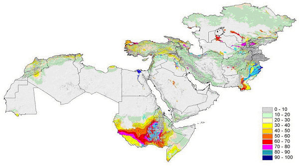
Fig. 7. Agricultural Resource Potential Index for CWANA (scale 0-100; 100 best)
This method, based on the concept of Agricultural Resource Potential Index (ARI), was used for mapping agricultural incomes in Syria (Fig. 8).
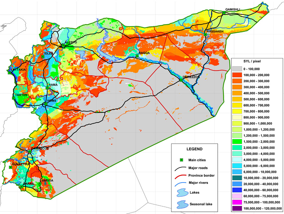
Fig. 8. Resource-based disaggregated distribution of total income from agriculture and livestock
Plans are underway to apply the method to other parts of CWANA as well, and to extend the ARI index mapping to all developing countries in order to allow a simple but objective comparison of resource potential.
While the ARI-method is fairly scale-independent, a proper understanding of poverty at household levels also requires knowledge about the land and water resources that households have access to. To this effect the GISU has developed a participatory approach, involving farmers and land users, aimed at capturing local agroecological knowledge (Fig.9). In collaboration with MP5 these approaches will be applied in poverty studies in different parts of Northwest Syria.
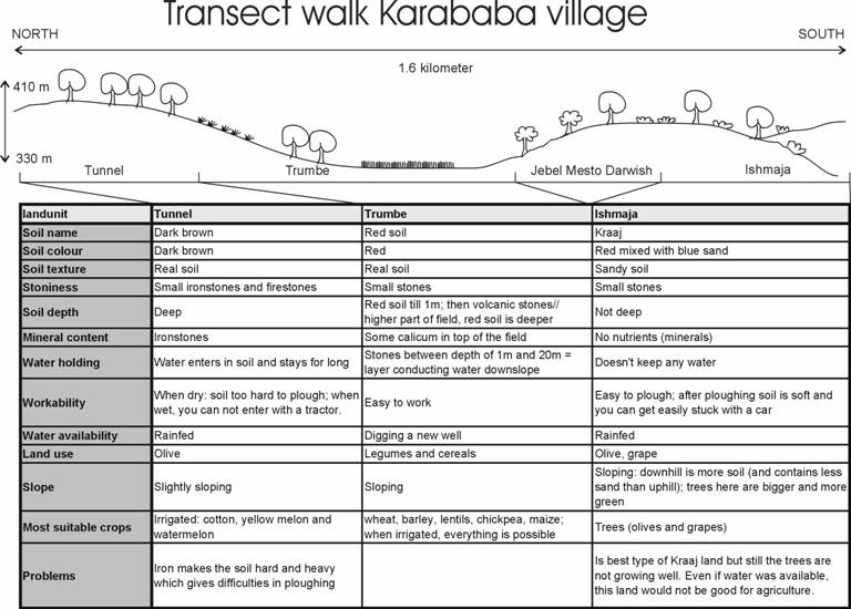
Fig. 9. Example of a participatory resource-based transect walk, Karababa, NW Syria
New methods of land suitability analysis based on the matching in GIS of biophysical environments with the environmental requirements of crops and production systems are operationalized. They require limited data and rely on the capturing of expert knowledge about crop-environment interactions and their integration in empirical decision models using crisp or fuzzy rules. The map products currently available include estimates of the likelihood of belonging to a particular suitability class and the nature of resource problems. The generalized framework for this approach is illustrated in Fig.5 which shows the various steps of the land suitability evaluation process.
GISU is developing map products and methodologies for targeting different crops and varieties to specific environments.
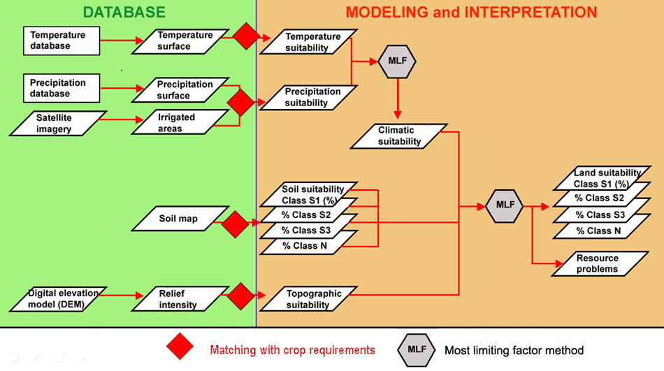
Fig.5. Overview of the empirical decision model used for land suitability studies
While refining the above methods, the GISU has made a start with developing mapping products specifically targeting agricultural decision-makers using the concept of 'agricultural regions. Agricultural regions are integrated spatial units in which available water resources, climate, terrain, and soil conditions combine to create unique environments. These are associated with distinct farming systems and land-use and settlement patterns. The concept of agricultural regions is particularly useful to establish development profiles for individualized spatial entities ('development domains') at sub-national level by providing a spatial communality for land use policy recommendations, agricultural investment alternatives etc. Collaboration has been established with NARS in Syria, Turkey, and Iran to establish similar spatial frameworks for respective countries (Fig.6).
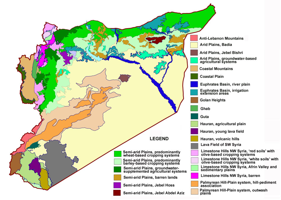
Fig. 6. Provisional agricultural regions of Syria