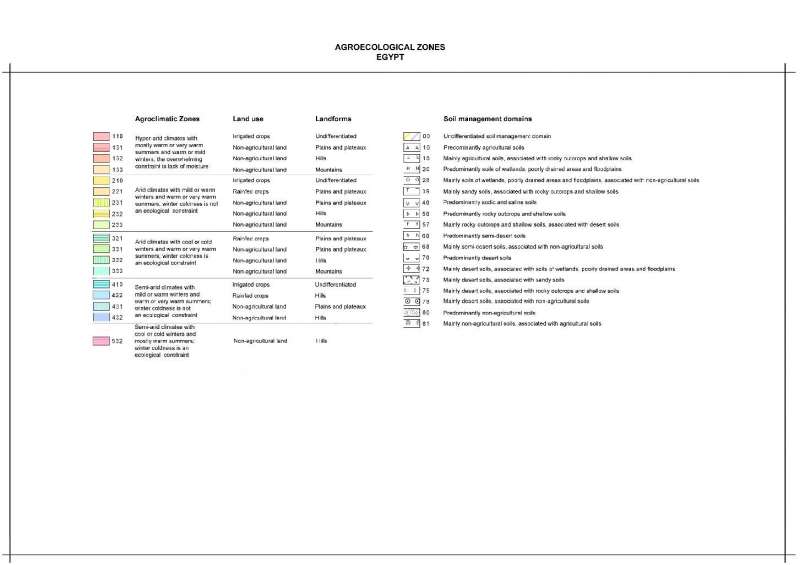
Intersections of agroclimatic zones for the period 1980 to 1999 with land-use and land-form zones.
OriginatorInternational Center for Agricultural Research in the Dry Areas (ICARDA)
Publication Date2008
TitleEgypt: Mean Annual Precipitation 1980-1999
Geospatial Data Presentation Formvector digital data
Online Linkagehttp://gu.icarda.org/geocms/public/en/cms/metadata/index/143/Egypt%3A+Mean+Annual+Precipitation+1980%2D1999/
AbstractIntersections of agroclimatic zones for the period 1980 to 1999 with land-use and land-form zones.
PurposeWFP Workshop on "Climate Change and Food Security", Cairo, Egypt, 3-4 November 2008
Supplemental InformationSource: Generated by GIS Unit, ICARDA. For a description see: E. De Pauw, 2008 (unpublished): CWANA and Northern Mediterranean: Agroecological Zones. ICARDA, Aleppo, Syria.
Calendar Date1980
Time of Day1999
Currentness Referenceground condition
ProgressComplete
Maintenance and Update FrequencyNone planned
West Bounding Coordinate23.994643
East Bounding Coordinate40.999878
North Bounding Coordinate33.001723
South Bounding Coordinate20.994313
Theme Keyword ThesaurusREQUIRED: Reference to a formally registered thesaurus or a similar authoritative source of theme keywords.
Theme KeywordCurrent climate
Theme KeywordLand use
Theme KeywordLand forms
Theme Keywordagroclimatic zones
Theme Keywordagro-ecological zones
Place KeywordCWANA
Place KeywordEgypt
Access ConstraintsOpen access policy: reproduction and distribution of this dataset is allowed subject to proper citation (see citation information)
Use ConstraintsFair use policy: commercialization of this dataset is not allowed. No constraints on use in applications, whether for commercial or non-profit.
Contact OrganizationInternational Center for Research in the Dry Areas
Contact PersonICARDA, Geoinformatics Unit
Contact PositionICARDA, Geoinformatics Unit
Contact Voice Telephone+ 961 1 843472/813303
Contact Facsimile Telephone+ 961 1 804071/01-843473
Contact Electronic Mail Addressicarda-gisu@cgiar.org
Hours of Service7.30 AM - 3.00 PM
Browse Graphic File Namehttp://geonet.icarda.cgiar.org/geonetwork/data/regional/WFP/Egypt/Thumbnail/Egypt_Annual_Precip_1980-99_A3.jpg
Browse Graphic File DescriptionLow Resolution (90dpi)
Browse Graphic File TypeJPG
Browse Graphic File Namehttp://geonet.icarda.cgiar.org/geonetwork/data/regional/WFP/Egypt/Map/Egypt_Annual_Precip_1980-99_A3.tif
Browse Graphic File DescriptionHigh Resolution (300dpi)
Browse Graphic File TypeTIFF
Browse Graphic File Namehttp://geonet.icarda.cgiar.org/geonetwork/data/regional/WFP/Egypt/Thumbnail/Egypt_AgroEcologicalZones_Legend_A3.jpg
Browse Graphic File DescriptionMap Legend
Data Set CreditPrepared by GIS Unit, ICARDA, 2008.
Attribute Accuracy ReportData values for all stations have been checked for plausibility
Horizontal Positional Accuracy ReportGeographical accuracy of all stations has been checked
Vertical Positional Accuracy ReportElevation accuracy for all stations has been checked against GTOPO30 DEM
Process DescriptionCreating the Metadata
Process Date2009
Process DescriptionDataset copied.
Source Used Citation AbbreviationC:\Documents and Settings\fdelobel\Desktop\Eddy2\Egypt WFP DATA\Egypt_Layers_2\AgroEcologicalZones1980-99Layers\AgroEcologicalZones1980-99Layers\Eg_AEZ\Eg_ACZ_LandUse_LandForm
Process Date20090611
Process Time09422200
Direct Spatial Reference MethodVector
SDTS Point and Vector Object TypeG-polygon
Point and Vector Object Count511
Raster Object TypeGrid Cell
Row Count1440
Column Count2040
Vertical Count1
Latitude Resolution0.000000
Longitude Resolution0.000000
Geographic Coordinate UnitsDecimal degrees
Horizontal Datum NameD_WGS_1984
Ellipsoid NameWGS_1984
Semi-major Axis6378137.000000
Denominator of Flattening Ratio298.257224
Entity Type LabelEg_ACZ_LandUse_LandForm
Attribute LabelFID
Attribute DefinitionInternal feature number.
Attribute Definition SourceESRI
Unrepresentable DomainSequential unique whole numbers that are automatically generated.
Attribute LabelShape
Attribute DefinitionFeature geometry.
Unrepresentable DomainCoordinates defining the features.
Attribute LabelGRIDCODE
Attribute LabelGRIDCODE_1
Attribute LabelSoil
Attribute LabelLandForm
Attribute LabelLandUse
Attribute LabelClimate
Attribute LabelArea
Attribute LabelACZ_LU_LF
Attribute LabelACZ_U_F_in
Resource DescriptionDownloadable Data
Distribution LiabilityICARDA declines all responsibility for errors or deficiencies in the database or in the documentation accompanying it, for maintenance or for updating the database. Users are however kindly requested to report any errors or deficiencies in this product to ICARDA. ICARDA is no authority on country boundaries and follows UN practice regarding country boundary location, as indicated on the United Nations Cartographic Website: http://www.un.org/Depts/Cartographic/english/htmain.htm
Transfer Size0.564
Technical PrerequisitesArcGIS, or ArcView with Spatial Analyst extension. Metadata can be read directly in ArcCatalog or in a Web browser using the HTML pages provided separately.
Metadata Date20090730
Contact OrganizationInternational Center for Research in the Dry Areas - ICARDA
Contact PersonFrancois Delobel
Contact PositionConsultant, Geoinformatics Unit
Address Typemailing and physical address
AddressICARDA, P.O. Box 114/5055
CityBeirut
State or ProvinceBeirut
Postal Code
CountryLebanon
Contact Electronic Mail Addressf.delobel@cgiar.org
Metadata Standard NameFGDC Content Standards for Digital Geospatial Metadata
Metadata Standard VersionFGDC-STD-001-1998
Metadata Time Conventionlocal time
Online Linkagehttp://www.esri.com/metadata/esriprof80.html
metprofESRI Metadata Profile
Select country...ArmeniaAfghanistanAlbaniaAlgeriaAmerican SamoaAndorraAngolaAntigua and BarbudaArgentinaAustraliaAustriaBahamasBahrainBarbadosBangladeshBermudaBhutanBoliviaBotswanaBrazilArubaBelizeBritish Indian Ocean TerSolomon IslandsBrunei DarussalamBulgariaMyanmarBurundiAntarcticaBouvet IslandCameroonCanadaCape VerdeCayman IslandCentral African RepublicSri LankaChadChileChina, MainlandChristmas IslandCocos IslandsColombiaComorosCongo, Republic ofCook IslandsCosta RicaCubaCyprusAzerbaijan, Republic ofBeninDenmarkDominicaDominican RepublicBelarusEcuadorEgyptEl SalvadorEquatorial GuineaEstoniaFaeroe IslandsFalkland IslandsFiji IslandsFinlandFranceFrench GuianaFrench PolynesiaFrench South TerrDjiboutiGeorgiaGabonGambiaGaza StripGermanyBosnia and HerzegovinaGhanaGibraltarKiribatiGreeceGreenlandGrenadaGuadeloupeGuamGuatemalaGuineaGuyanaHeard and McDonald IsHaitiHondurasHungaryCroatiaIcelandIndiaIndonesiaIran, Islamic Rep ofIraqIrelandIsraelItalyIvory CoastKazakhstanJamaicaJapanJordanKyrgyzstanKenyaCambodiaKorea, Dem People's RepKorea, Republic ofKuwaitLatviaLaosLebanonLesothoLiberiaLibyan Arab JamahiriyaLiechtenstenLithuaniaMarshall IslandMadagascarMalawiMalaysiaMaldivesMaliMaltaMartiniqueMauritaniaMauritiusMexicoMidway IslandsMonacoMongoliaMontserratMoroccoMozambiqueMicronesia,Fed States ofMoldova, Republic ofNamibiaNauruNepalNetherlandsNeth AntillesNewCaledoniaMacedoniaVanuatuNew ZealandNicaraguaNigerNigeriaNiueNorfolk IslandNorwayNorthern Mariana IsPakistanPanamaCzech RepublicPapua New GuineaParaguayPeruPhilippinesPitcairn IslandsPolandPortugalGuinea-BissauEast TimorPuerto RicoEritreaQatarZimbabweReunionRomaniaRwandaRussian FederationSaint HelenaSaint Kitts and NevisSaint LuciaSaint Pierre & MiquelonSaint Vincent/GrenadinesSan MarinoSao Tome and PrincipeSaudi ArabiaSenegalSeychellesSierra LeoneSloveniaSlovakiaSingaporeSomaliaSouth AfricaSpainWestern SaharaSudanSurinameTajikistanSwazilandSwedenSwitzerlandSyrian Arab RepublicTurkmenistanChina, Taiwan Prov ofTanzania, United Rep ofThailandTogoTokelauTongaTrinidad and TobagoOmanTunisiaTurkeyTurks and Caicos IsUnited Arab EmiratesUgandaTuvaluUnited KingdomUkraineUnited States of AmericaUS Minor Outlying IsBurkina FasoUruguayUzbekistanVenezuelaViet NamEthiopiaBritish Virgin IslandUS Virgin IslandsWake IslandWallis and Futuna IsSamoaWest BankYemenCongo, Dem Republic ofZambiaBelgiumLuxembourgAnguillaSvalbard IsIsle of ManMayotteSouthGeorgia/Sandwich IsWestern EuropeIntergvt Author DevpmentNorth Western AfricaWestern AfricaCentral AfricaEastern AfricaSouthern AfricaLatin Amer & CaribbeanCentral AmericaCaribbeanSouth AmericaNear EastNear East in AfricaNear East in AsiaFar EastSouth AsiaEast & South East AsiaNear East and North AfricaEastern EuropeEuropeAsiaAfricaLatin AmericaSerbiaMontenegroSouth of SaharaNorth AfricaEurope, Non-EU CountriesNorth AmericaUSSR, Former Area ofArctic SeaAtlantic, NorthwestAtlantic, NortheastAtlantic, Western CentralAtlantic, Eastern CentralMediterran and Black SeaAtlantic, SouthwestAtlantic, SoutheastAtlantic, AntarcticIndian Ocean, WesternIndian Ocean, EasternIndian Ocean, AntarcticPacific, NorthwestPacific, NortheastPacific, Western CentralPacific, Eastern CentralPacific, SouthwestPacific, SoutheastPacific, AntarcticAll fishing areasWorld
Africa Asia Australia and Oceania Central America and the Caribbean Europe Middle East and North Africa North America South America
login failed
Message Body Goes Here
Failed


