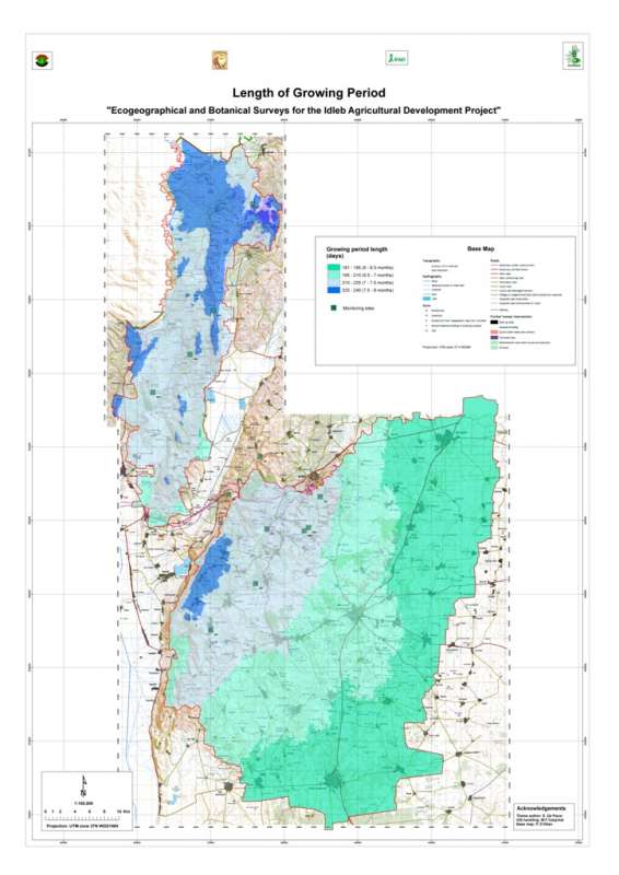
Length of the growing perion in the Jebel Wastani area.
OriginatorInternational Center for Agricultural Research in the Dry Areas (ICARDA)
Publication Date2008
TitleJebel Wastani: Growing Period
Geospatial Data Presentation Formraster digital data
Online Linkagehttp://gu.icarda.org/geocms/public/en/cms/metadata/index/234/Jebel+Wastani%3A+Growing+Period/
AbstractLength of the growing perion in the Jebel Wastani area.
PurposeCharacterisation of the agricultural environment in Jebel Zawia and in Jebel Wastani with a view to develop management plans for areas with valuable plant biodiversity (Idleb Rural Development Project)
Supplemental InformationMethodology: The moisture- and temperature-limited growing period results from the combination of both moisture-limited and temperature-limited growing periods (most limiting factor method). The moisture-limited growing period is defined as the period for which the ratio of actual evapotranspiration (AET) to potential evapotranspiration (PET) is higher than 0.5. The temperature-limited growing period is defined as the period for which the average temperature is higher than 5���������������°C.
Calendar Date2008
Currentness Referencepublication date
ProgressComplete
Maintenance and Update FrequencyNone planned
West Bounding Coordinate36.286639
East Bounding Coordinate36.566675
North Bounding Coordinate36.230450
South Bounding Coordinate35.740842
Theme Keyword ThesaurusREQUIRED: Reference to a formally registered thesaurus or a similar authoritative source of theme keywords.
Theme Keywordclimate
Theme Keywordgrowing period
Place KeywordSyria
Place KeywordIdleb
Place KeywordWastani
Access ConstraintsOpen access policy: reproduction and distribution of this dataset is allowed subject to proper citation (see citation information)
Use ConstraintsFair use policy: commercialization of this dataset is not allowed. No constraints on use in applications, whether for commercial or non-profit.
Contact OrganizationInternational Center for Research in the Dry Areas
Contact PersonICARDA, Geoinformatics Unit
Contact PositionICARDA, Geoinformatics Unit
Contact Voice Telephone+ 961 1 843472/813303
Contact Facsimile Telephone+ 961 1 804071/01-843473
Contact Electronic Mail Addressicarda-gisu@cgiar.org
Hours of Service7.30 AM - 3.00 PM
Browse Graphic File Namehttp://geonet.icarda.cgiar.org/geonetwork/data/sub-national/Idleb/Thumbnail/LGP_Layout.jpg
Browse Graphic File DescriptionLow Resolution (90dpi)
Browse Graphic File TypeJPEG
Browse Graphic File Namehttp://geonet.icarda.cgiar.org/geonetwork/data/sub-national/Idleb/Map/LGP_Layout.tif
Browse Graphic File DescriptionHigh Resolution (200dpi)
Browse Graphic File TypeTIFF
Browse Graphic File Namehttp://geonet.icarda.cgiar.org/geonetwork/data/sub-national/Idleb/Doc/Report_Idleb.pdf
Browse Graphic File DescriptionFor additional details on the methodology, please refer to
Browse Graphic File TypePDF
Attribute Accuracy ReportData values for all stations have been checked for plausibility
Horizontal Positional Accuracy ReportGeographical accuracy of all stations has been checked
Vertical Positional Accuracy ReportElevation accuracy for all stations has been checked against GTOPO30 DEM
Process DescriptionCreating the Metadata
Process Date2009
Direct Spatial Reference MethodRaster
Raster Object TypeGrid Cell
Row Count597
Column Count265
Vertical Count1
Grid Coordinate System NameUniversal Transverse Mercator
UTM Zone Number37
Scale Factor at Central Meridian0.999600
Longitude of Central Meridian39.000000
Latitude of Projection Origin0.000000
False Easting500000.000000
False Northing0.000000
Planar Coordinate Encoding Methodrow and column
Abscissa Resolution90.000000
Ordinate Resolution90.000000
Planar Distance Unitsmeters
Horizontal Datum NameD_WGS_1984
Ellipsoid NameWGS_1984
Semi-major Axis6378137.000000
Denominator of Flattening Ratio298.257224
Entity Type Labelaeu_nibb_was.vat
Attribute LabelRowid
Attribute DefinitionInternal feature number.
Attribute Definition SourceESRI
Unrepresentable DomainSequential unique whole numbers that are automatically generated.
Attribute LabelVALUE
Attribute LabelCOUNT
Resource DescriptionDownloadable Data
Distribution LiabilityICARDA declines all responsibility for errors or deficiencies in the database or in the documentation accompanying it, for maintenance or for updating the database. Users are however kindly requested to report any errors or deficiencies in this product to ICARDA. ICARDA is no authority on country boundaries and follows UN practice regarding country boundary location, as indicated on the United Nations Cartographic Website: http://www.un.org/Depts/Cartographic/english/htmain.htm
Transfer Size0.631
Technical PrerequisitesArcGIS, or ArcView with Spatial Analyst extension. Metadata can be read directly in ArcCatalog or in a Web browser using the HTML pages provided separately.
Metadata Date20090810
Contact OrganizationInternational Center for Research in the Dry Areas - ICARDA
Contact PersonFrancois Delobel
Contact PositionConsultant, Geoinformatics Unit
Address Typemailing and physical address
AddressICARDA, P.O. Box 114/5055
CityBeirut
State or ProvinceBeirut
Postal Code
CountryLebanon
Contact Electronic Mail Addressf.delobel@cgiar.org
Metadata Standard NameFGDC Content Standards for Digital Geospatial Metadata
Metadata Standard VersionFGDC-STD-001-1998
Metadata Time Conventionlocal time
Online Linkagehttp://www.esri.com/metadata/esriprof80.html
metprofESRI Metadata Profile
Select country...ArmeniaAfghanistanAlbaniaAlgeriaAmerican SamoaAndorraAngolaAntigua and BarbudaArgentinaAustraliaAustriaBahamasBahrainBarbadosBangladeshBermudaBhutanBoliviaBotswanaBrazilArubaBelizeBritish Indian Ocean TerSolomon IslandsBrunei DarussalamBulgariaMyanmarBurundiAntarcticaBouvet IslandCameroonCanadaCape VerdeCayman IslandCentral African RepublicSri LankaChadChileChina, MainlandChristmas IslandCocos IslandsColombiaComorosCongo, Republic ofCook IslandsCosta RicaCubaCyprusAzerbaijan, Republic ofBeninDenmarkDominicaDominican RepublicBelarusEcuadorEgyptEl SalvadorEquatorial GuineaEstoniaFaeroe IslandsFalkland IslandsFiji IslandsFinlandFranceFrench GuianaFrench PolynesiaFrench South TerrDjiboutiGeorgiaGabonGambiaGaza StripGermanyBosnia and HerzegovinaGhanaGibraltarKiribatiGreeceGreenlandGrenadaGuadeloupeGuamGuatemalaGuineaGuyanaHeard and McDonald IsHaitiHondurasHungaryCroatiaIcelandIndiaIndonesiaIran, Islamic Rep ofIraqIrelandIsraelItalyIvory CoastKazakhstanJamaicaJapanJordanKyrgyzstanKenyaCambodiaKorea, Dem People's RepKorea, Republic ofKuwaitLatviaLaosLebanonLesothoLiberiaLibyan Arab JamahiriyaLiechtenstenLithuaniaMarshall IslandMadagascarMalawiMalaysiaMaldivesMaliMaltaMartiniqueMauritaniaMauritiusMexicoMidway IslandsMonacoMongoliaMontserratMoroccoMozambiqueMicronesia,Fed States ofMoldova, Republic ofNamibiaNauruNepalNetherlandsNeth AntillesNewCaledoniaMacedoniaVanuatuNew ZealandNicaraguaNigerNigeriaNiueNorfolk IslandNorwayNorthern Mariana IsPakistanPanamaCzech RepublicPapua New GuineaParaguayPeruPhilippinesPitcairn IslandsPolandPortugalGuinea-BissauEast TimorPuerto RicoEritreaQatarZimbabweReunionRomaniaRwandaRussian FederationSaint HelenaSaint Kitts and NevisSaint LuciaSaint Pierre & MiquelonSaint Vincent/GrenadinesSan MarinoSao Tome and PrincipeSaudi ArabiaSenegalSeychellesSierra LeoneSloveniaSlovakiaSingaporeSomaliaSouth AfricaSpainWestern SaharaSudanSurinameTajikistanSwazilandSwedenSwitzerlandSyrian Arab RepublicTurkmenistanChina, Taiwan Prov ofTanzania, United Rep ofThailandTogoTokelauTongaTrinidad and TobagoOmanTunisiaTurkeyTurks and Caicos IsUnited Arab EmiratesUgandaTuvaluUnited KingdomUkraineUnited States of AmericaUS Minor Outlying IsBurkina FasoUruguayUzbekistanVenezuelaViet NamEthiopiaBritish Virgin IslandUS Virgin IslandsWake IslandWallis and Futuna IsSamoaWest BankYemenCongo, Dem Republic ofZambiaBelgiumLuxembourgAnguillaSvalbard IsIsle of ManMayotteSouthGeorgia/Sandwich IsWestern EuropeIntergvt Author DevpmentNorth Western AfricaWestern AfricaCentral AfricaEastern AfricaSouthern AfricaLatin Amer & CaribbeanCentral AmericaCaribbeanSouth AmericaNear EastNear East in AfricaNear East in AsiaFar EastSouth AsiaEast & South East AsiaNear East and North AfricaEastern EuropeEuropeAsiaAfricaLatin AmericaSerbiaMontenegroSouth of SaharaNorth AfricaEurope, Non-EU CountriesNorth AmericaUSSR, Former Area ofArctic SeaAtlantic, NorthwestAtlantic, NortheastAtlantic, Western CentralAtlantic, Eastern CentralMediterran and Black SeaAtlantic, SouthwestAtlantic, SoutheastAtlantic, AntarcticIndian Ocean, WesternIndian Ocean, EasternIndian Ocean, AntarcticPacific, NorthwestPacific, NortheastPacific, Western CentralPacific, Eastern CentralPacific, SouthwestPacific, SoutheastPacific, AntarcticAll fishing areasWorld
Africa Asia Australia and Oceania Central America and the Caribbean Europe Middle East and North Africa North America South America
login failed
Message Body Goes Here
Failed


