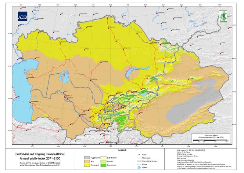
Annual Aridity Index for Central Asia and Xingjiang Province (China) at 30 arc-second ( about 1 km) resolution
OriginatorInternational Center for Agricultural Research in the Dry Areas (ICARDA)
Publication Date2010
TitleCentral Asia and Xingjiang Province (China) Annual aridity index 2071-2100 A1b Scenario
Geospatial Data Presentation Formraster digital data
Online Linkagehttp://gu.icarda.org/geocms/public/en/cms/metadata/index/813/CAX%252BAnnual%252Baridity%252Bindex%252B2071-2100%252BA1b%252BScenario/
AbstractAnnual Aridity Index for Central Asia and Xingjiang Province (China) at 30 arc-second ( about 1 km) resolution
PurposeTo provide a measure of aridity for specific locations using an index
Supplemental InformationThe annual aridity index is the ratio of annual precipitation over annual potential evapotranspiration (dimensionless unit)
Beginning Date2071
Ending Date2100
Currentness Referencepublication date
ProgressComplete
Maintenance and Update FrequencyIrregular
West Bounding Coordinate51.218469686
East Bounding Coordinate103.047567786
North Bounding Coordinate52.69812595
South Bounding Coordinate32.817056204
Place KeywordTajikistan
Place KeywordTurkmenistan
Place KeywordKazakhstan
Place KeywordUzbekistan
Place KeywordKyrgyzstan
Place KeywordXingjiang Province
Access ConstraintsOpen access policy: this dataset is an international public good. Distribution of this dataset is allowed subject to proper citation (see citation information)
Use ConstraintsFair use policy: commercialization of this dataset is not allowed. No constraints on use in applications, whether for commercial or non-profit use
Contact PersonICARDA, Geoinformatics Unit
Contact OrganizationInternational Center for Agricultural Research in the Dry Areas (ICARDA)
Contact PositionICARDA, Geoinformatics Unit
Contact Voice Telephone+ 961 1 843472/813303
Contact Facsimile Telephone+ 961 1 804071/01-843473
Contact Electronic Mail Addressicarda-gisu@cgiar.org
OriginatorE. De Pauw, W. Goebel and F. Delobel
TitleUsing GIS to develop a baseline dataset for planning adaptation strategies to climate change in Central Asia and Northwest China
Other Citation DetailsTechnical Report, GIS Unit ICARDA
Browse Graphic File Namehttp://gu.icarda.org/graph/getfullimage/0/0/regional_-_cax_-_jpg_-_CAX+Annual+aridity+index+70_100_A1b.jpg
Browse Graphic File TypeJPG
Browse Graphic File Namehttp://gu.icarda.org/graph/getfullimage/0/0/regional_-_cax_-_tiff_-_CAX+Annual+aridity+index+70_100_A1b.tif
Browse Graphic File TypeTIFF
Direct Spatial Reference MethodRaster
Raster Object TypeGrid Cell
Row Count3122
Column Count6542
Vertical Count1
Latitude Resolution0.000000
Longitude Resolution0.000000
Geographic Coordinate UnitsDecimal degrees
Horizontal Datum NameD_WGS_1984
Ellipsoid NameWGS_1984
Semi-major Axis6378137.000000
Denominator of Flattening Ratio298.257224
Resource DescriptionDownloadable Data
Distribution LiabilityICARDA declines all responsibility for errors or deficiencies in the database or in the documentation accompanying it, for maintenance or for updating the database. Users are however kindly requested to report any errors or deficiencies in this product to ICARDA. ICARDA is no authority on country boundaries and follows UN practice regarding country boundary location, as indicated on the United Nations Cartographic Website: <http://www.un.org/Depts/Cartographic/english/htmain.htm>
Transfer Size52.386
Technical PrerequisitesArcGIS, or ArcView with Spatial Analyst extension. Metadata can be read directly in ArcCatalog or in a Web browser using the HTML pages provided separately
Select country...ArmeniaAfghanistanAlbaniaAlgeriaAmerican SamoaAndorraAngolaAntigua and BarbudaArgentinaAustraliaAustriaBahamasBahrainBarbadosBangladeshBermudaBhutanBoliviaBotswanaBrazilArubaBelizeBritish Indian Ocean TerSolomon IslandsBrunei DarussalamBulgariaMyanmarBurundiAntarcticaBouvet IslandCameroonCanadaCape VerdeCayman IslandCentral African RepublicSri LankaChadChileChina, MainlandChristmas IslandCocos IslandsColombiaComorosCongo, Republic ofCook IslandsCosta RicaCubaCyprusAzerbaijan, Republic ofBeninDenmarkDominicaDominican RepublicBelarusEcuadorEgyptEl SalvadorEquatorial GuineaEstoniaFaeroe IslandsFalkland IslandsFiji IslandsFinlandFranceFrench GuianaFrench PolynesiaFrench South TerrDjiboutiGeorgiaGabonGambiaGaza StripGermanyBosnia and HerzegovinaGhanaGibraltarKiribatiGreeceGreenlandGrenadaGuadeloupeGuamGuatemalaGuineaGuyanaHeard and McDonald IsHaitiHondurasHungaryCroatiaIcelandIndiaIndonesiaIran, Islamic Rep ofIraqIrelandIsraelItalyIvory CoastKazakhstanJamaicaJapanJordanKyrgyzstanKenyaCambodiaKorea, Dem People's RepKorea, Republic ofKuwaitLatviaLaosLebanonLesothoLiberiaLibyan Arab JamahiriyaLiechtenstenLithuaniaMarshall IslandMadagascarMalawiMalaysiaMaldivesMaliMaltaMartiniqueMauritaniaMauritiusMexicoMidway IslandsMonacoMongoliaMontserratMoroccoMozambiqueMicronesia,Fed States ofMoldova, Republic ofNamibiaNauruNepalNetherlandsNeth AntillesNewCaledoniaMacedoniaVanuatuNew ZealandNicaraguaNigerNigeriaNiueNorfolk IslandNorwayNorthern Mariana IsPakistanPanamaCzech RepublicPapua New GuineaParaguayPeruPhilippinesPitcairn IslandsPolandPortugalGuinea-BissauEast TimorPuerto RicoEritreaQatarZimbabweReunionRomaniaRwandaRussian FederationSaint HelenaSaint Kitts and NevisSaint LuciaSaint Pierre & MiquelonSaint Vincent/GrenadinesSan MarinoSao Tome and PrincipeSaudi ArabiaSenegalSeychellesSierra LeoneSloveniaSlovakiaSingaporeSomaliaSouth AfricaSpainWestern SaharaSudanSurinameTajikistanSwazilandSwedenSwitzerlandSyrian Arab RepublicTurkmenistanChina, Taiwan Prov ofTanzania, United Rep ofThailandTogoTokelauTongaTrinidad and TobagoOmanTunisiaTurkeyTurks and Caicos IsUnited Arab EmiratesUgandaTuvaluUnited KingdomUkraineUnited States of AmericaUS Minor Outlying IsBurkina FasoUruguayUzbekistanVenezuelaViet NamEthiopiaBritish Virgin IslandUS Virgin IslandsWake IslandWallis and Futuna IsSamoaWest BankYemenCongo, Dem Republic ofZambiaBelgiumLuxembourgAnguillaSvalbard IsIsle of ManMayotteSouthGeorgia/Sandwich IsWestern EuropeIntergvt Author DevpmentNorth Western AfricaWestern AfricaCentral AfricaEastern AfricaSouthern AfricaLatin Amer & CaribbeanCentral AmericaCaribbeanSouth AmericaNear EastNear East in AfricaNear East in AsiaFar EastSouth AsiaEast & South East AsiaNear East and North AfricaEastern EuropeEuropeAsiaAfricaLatin AmericaSerbiaMontenegroSouth of SaharaNorth AfricaEurope, Non-EU CountriesNorth AmericaUSSR, Former Area ofArctic SeaAtlantic, NorthwestAtlantic, NortheastAtlantic, Western CentralAtlantic, Eastern CentralMediterran and Black SeaAtlantic, SouthwestAtlantic, SoutheastAtlantic, AntarcticIndian Ocean, WesternIndian Ocean, EasternIndian Ocean, AntarcticPacific, NorthwestPacific, NortheastPacific, Western CentralPacific, Eastern CentralPacific, SouthwestPacific, SoutheastPacific, AntarcticAll fishing areasWorld
Africa Asia Australia and Oceania Central America and the Caribbean Europe Middle East and North Africa North America South America
login failed
Message Body Goes Here
Failed


 Annual aridity index 2071-2100 A1b Scenario")