


Geoinformatics Solutions for Integrated Agro-ecosystems Research
GIS Data
Maps in: Suitability

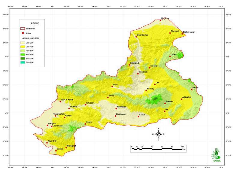
Pilot Area in NW Iran: Precipitation
Annual precipitation in the Aras and the Daryacheh-Uromieh basins, North-West Iran
Metadataclose[x]
Pilot Area in NW Iran: Precipitation
Characterization of the agro-ecological conditions in the pilot area of Aras and Daryacheh-Uromieh basins (North-West Iran), with the view to determine the land suitability for a range of crop groups in the area
Annual precipitation in the Aras and the Daryacheh-Uromieh basins, North-West Iran
International Center for Agricultural Research in the Dry Areas (ICARDA)
2008
agro-ecosystems, climate, precipitation
Iran, pilot area, Aras and Daryacheh-Uromieh basins
46.100529
49.162195
34.960947
30.953447
D_WGS_1984
WGS_1984
6378137.000000
298.257224

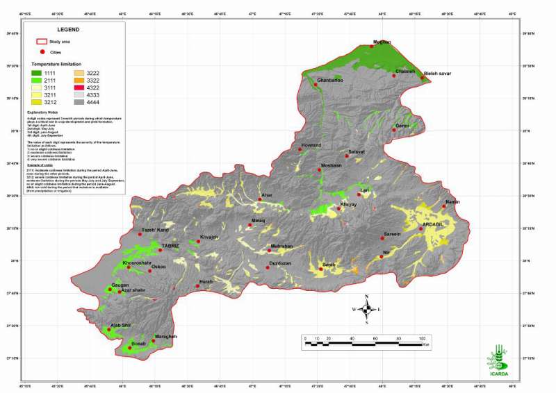
Pilot Area in NW Iran: Adequacy of Temperature for Safflower
Suitability of temperature for safflower crops in the Aras and the Daryacheh-Uromieh basins, North-West Iran. The suitability is determined by crop-specific thresholds defined on a degree.days scale.
Metadataclose[x]
Pilot Area in NW Iran: Adequacy of Temperature for Safflower
Determine the climate and the land suitability for safflower crops in the study area
Suitability of temperature for safflower crops in the Aras and the Daryacheh-Uromieh basins, North-West Iran. The suitability is determined by crop-specific thresholds defined on a degree.days scale.
International Center for Agricultural Research in the Dry Areas (ICARDA)
2008
suitability, climate, temperature, safflower
Iran, pilot area, Aras and Daryacheh-Uromieh basins
46.100529
49.162195
34.960947
30.953447
D_WGS_1984
WGS_1984
6378137.000000
298.257224

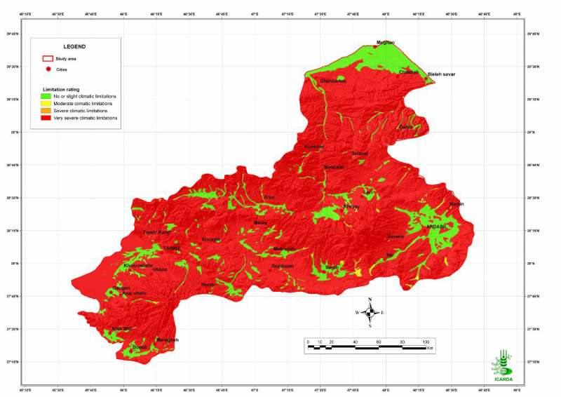
Pilot Area in NW Iran: Adequacy of Climate for Safflower
Suitability of climate conditions (temperature and precipitation) for safflower crops in the Aras and the Daryacheh-Uromieh basins, North-West Iran. Since the precipitation regime is insufficient in all the area, this map assumes an appropriate irrigation for the crops.
Metadataclose[x]
Pilot Area in NW Iran: Adequacy of Climate for Safflower
Determine the land suitability for safflower crops in the study area
Suitability of climate conditions (temperature and precipitation) for safflower crops in the Aras and the Daryacheh-Uromieh basins, North-West Iran. Since the precipitation regime is insufficient in all the area, this map assumes an appropriate irrigation for the crops.
International Center for Agricultural Research in the Dry Areas (ICARDA)
2008
safflower, climate, temperature, precipitation, sugarbeet
Iran, pilot area, Aras and Daryacheh-Uromieh basins
46.100529
49.162195
34.960947
30.953447
D_WGS_1984
WGS_1984
6378137.000000
298.257224

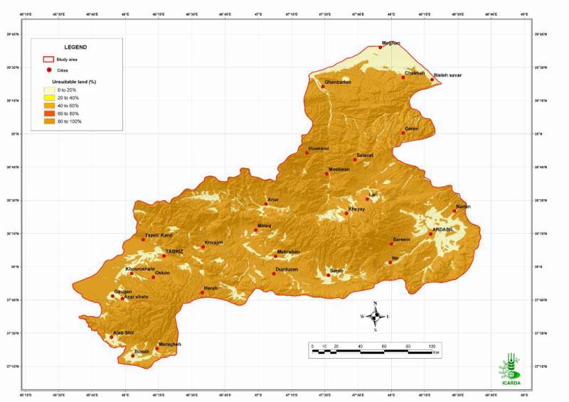
Pilot Area in NW Iran: Unsuitable Land for Safflower
Percentage of unsuitable land (all factors combined) for safflower crops in the Aras and the Daryacheh-Uromieh basins, North-West Iran. The factors, climate, soils and topography, are integrated by the method of the most limiting factor.
Metadataclose[x]
Pilot Area in NW Iran: Unsuitable Land for Safflower
Determine the land suitability for safflower crops in the study area
Percentage of unsuitable land (all factors combined) for safflower crops in the Aras and the Daryacheh-Uromieh basins, North-West Iran. The factors, climate, soils and topography, are integrated by the method of the most limiting factor.
International Center for Agricultural Research in the Dry Areas (ICARDA)
2008
suitability, climate, topography, soil, unsuitable land, safflower
Iran, pilot area, Aras and Daryacheh-Uromieh basins
46.100529
49.162195
34.960947
30.953447
D_WGS_1984
WGS_1984
6378137.000000
298.257224

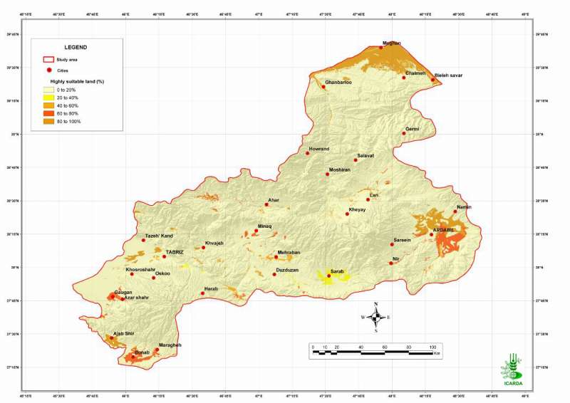
Pilot Area in NW Iran: Highly Suitable Land for Safflower
Percentage of highly suitable land (all factors combined) for safflower crops in the Aras and the Daryacheh-Uromieh basins, North-West Iran. The factors, climate, soils and topography, are integrated by the method of the most limiting factor. The map assumes that the crops are properly irrigated.
Metadataclose[x]
Pilot Area in NW Iran: Highly Suitable Land for Safflower
Determine the land suitability for safflower crops in the study area
Percentage of highly suitable land (all factors combined) for safflower crops in the Aras and the Daryacheh-Uromieh basins, North-West Iran. The factors, climate, soils and topography, are integrated by the method of the most limiting factor. The map assumes that the crops are properly irrigated.
International Center for Agricultural Research in the Dry Areas (ICARDA)
2008
suitability, climate, topography, soil, safflower
Iran, pilot area, Aras and Daryacheh-Uromieh basins
46.100529
49.162195
34.960947
30.953447
D_WGS_1984
WGS_1984
6378137.000000
298.257224

Pilot Area in NW Iran: Moderately Suitable Land for Safflower
Percentage of moderately suitable land (all factors combined) for safflower crops in the Aras and the Daryacheh-Uromieh basins, North-West Iran. The factors, climate, soils and topography, are integrated by the method of the most limiting factor. The map assumes that the crops are properly irrigated.
Metadataclose[x]
Pilot Area in NW Iran: Moderately Suitable Land for Safflower
Determine the land suitability for safflower crops in the study area
Percentage of moderately suitable land (all factors combined) for safflower crops in the Aras and the Daryacheh-Uromieh basins, North-West Iran. The factors, climate, soils and topography, are integrated by the method of the most limiting factor. The map assumes that the crops are properly irrigated.
International Center for Agricultural Research in the Dry Areas (ICARDA)
2008
suitability, climate, topography, soil, safflower
Iran, pilot area, Aras and Daryacheh-Uromieh basins
46.100529
49.162195
34.960947
30.953447
D_WGS_1984
WGS_1984
6378137.000000
298.257224

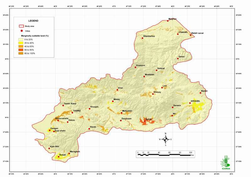
Pilot Area in NW Iran: Marginally Suitable Land for Safflower
Percentage of marginally suitable land (all factors combined) for safflower crops in the Aras and the Daryacheh-Uromieh basins, North-West Iran. The factors, climate, soils and topography, are integrated by the method of the most limiting factor. The map assumes that the crops are properly irrigated.
Metadataclose[x]
Pilot Area in NW Iran: Marginally Suitable Land for Safflower
Determine the land suitability for safflower crops in the study area
Percentage of marginally suitable land (all factors combined) for safflower crops in the Aras and the Daryacheh-Uromieh basins, North-West Iran. The factors, climate, soils and topography, are integrated by the method of the most limiting factor. The map assumes that the crops are properly irrigated.
International Center for Agricultural Research in the Dry Areas (ICARDA)
2008
suitability, climate, topography, soil, safflower
Iran, pilot area, Aras and Daryacheh-Uromieh basins
46.100529
49.162195
34.960947
30.953447
D_WGS_1984
WGS_1984
6378137.000000
298.257224

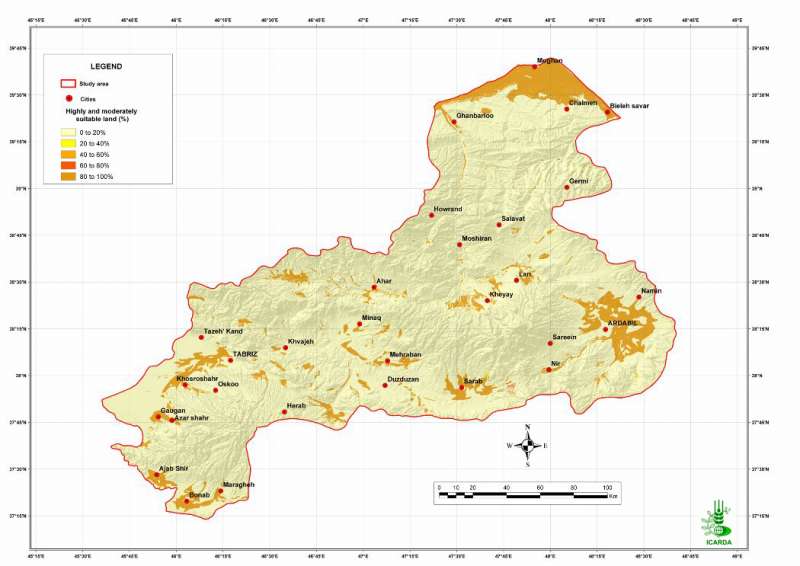
Pilot Area in NW Iran: Suitable Land for Safflower
Percentage of highly and moderately suitable land (all factors combined) for safflower crops in the Aras and the Daryacheh-Uromieh basins, North-West Iran. The factors, climate, soils and topography, are integrated by the method of the most limiting factor. The map assumes that the crops are properly irrigated.
Metadataclose[x]
Pilot Area in NW Iran: Suitable Land for Safflower
Determine the land suitability for safflower crops in the study area
Percentage of highly and moderately suitable land (all factors combined) for safflower crops in the Aras and the Daryacheh-Uromieh basins, North-West Iran. The factors, climate, soils and topography, are integrated by the method of the most limiting factor. The map assumes that the crops are properly irrigated.
International Center for Agricultural Research in the Dry Areas (ICARDA)
2008
suitability, climate, topography, soil, suitable land, safflower
Iran, pilot area, Aras and Daryacheh-Uromieh basins
46.100529
49.162195
34.960947
30.953447
D_WGS_1984
WGS_1984
6378137.000000
298.257224

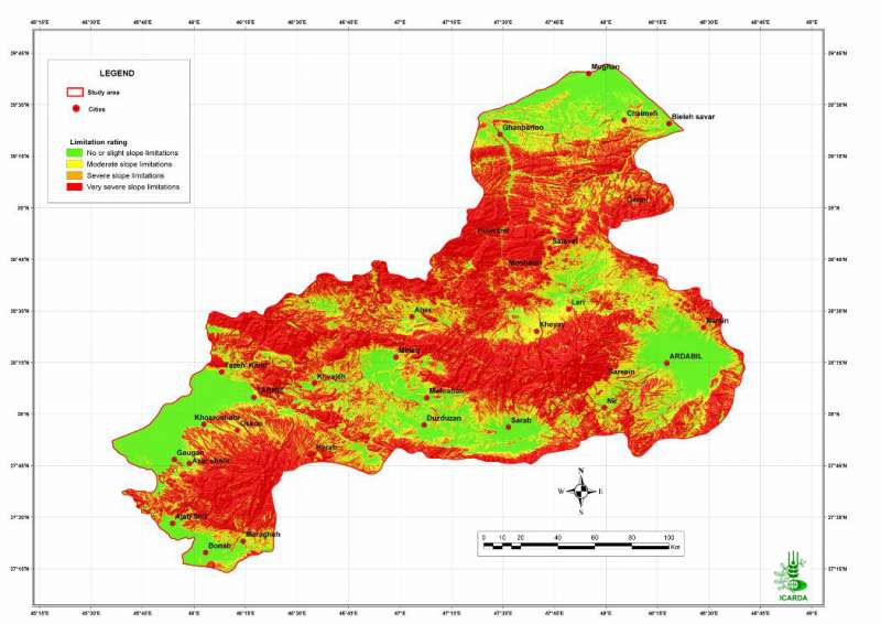
Pilot Area in NW Iran: Adequacy of Topography for Safflower
Suitability of topography for safflower crops in the Aras and the Daryacheh-Uromieh basins, North-West Iran
Metadataclose[x]
Pilot Area in NW Iran: Adequacy of Topography for Safflower
Determine the land suitability for safflower crops in the study area
Suitability of topography for safflower crops in the Aras and the Daryacheh-Uromieh basins, North-West Iran
International Center for Agricultural Research in the Dry Areas (ICARDA)
2008
suitability, topography, slope, safflower
Iran, pilot area, Aras and Daryacheh-Uromieh basins
46.100529
49.162195
34.960947
30.953447
D_WGS_1984
WGS_1984
6378137.000000
298.257224

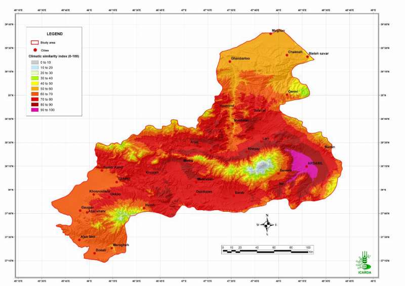
Pilot Area in NW Iran: Climatic Similarity with Arbadil
Relative climatic similarity (precipitation and temperature) with Ardabil in the Aras and the Daryacheh-Uromieh basins, North-West Iran
Metadataclose[x]
Pilot Area in NW Iran: Climatic Similarity with Arbadil
Evaluate the relative diversity in climate conditions within the study area. Characterization of the agro-ecological conditions in the pilot area of Aras and Daryacheh-Uromieh basins (North-West Iran), with the view to determine the land suitability for a range of crop groups in the area
Relative climatic similarity (precipitation and temperature) with Ardabil in the Aras and the Daryacheh-Uromieh basins, North-West Iran
International Center for Agricultural Research in the Dry Areas (ICARDA)
2008
agro-ecosystems, climate, similarity
Iran, pilot area, Aras and Daryacheh-Uromieh basins, Arbadil
46.100529
49.162195
34.960947
30.953447
D_WGS_1984
WGS_1984
6378137.000000
298.257224