


Geoinformatics Solutions for Integrated Agro-ecosystems Research
GIS Data
Global - Agriculture
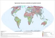
Agriculture resource constraints and global drylands
This map differentiates land according to the presence of key constraints of climate, topography and soils in the following classes:
- No major agricultural resource constraints
- Severe soil constraints: SRPI > 50
- Severe topographic constraints: TRPI > 50
- Severe topographic and soil constraints: TRPI > 50 and SRPI > 50
- Severe climatic constraints: CRPI > 75
- Severe climatic and soil constraints: CRPI >75 and SRPI > 50
- Severe climatic and topographic constraints: CRPI >75 and TRPI > 50
- Severe climatic, topographic and soil constraints: CRPI >75 and TRPI > 50 and SRPI > 50
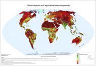
Global drylands and agriculture resource poverty
Agricultural resource poverty is a structural component of environmental poverty, which is principally determined by climatic, topographic and soil constraints, as well as lack of water resources for irrigation, where needed. This global map shows a quantified estimate of the constraints to agriculture as imposed by the biophysical environment, using an index approach, scaled to a range 0-100, with 100 expressing the highest degree of resource poverty. The map has been compiled as a synthesis of individual thematic resource poverty maps (climate, topography, soils and irrigation water resources).