


Geoinformatics Solutions for Integrated Agro-ecosystems Research
GIS Data
Maps in: CACILM

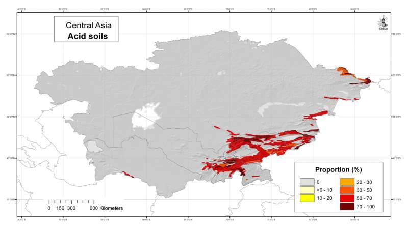
Central Asia: acid soils
Likelihood of the occurrence of acid soils in Central Asia at 30 arc-second ( about 1 km) resolution, derived from the FAO Soil Map of the World
Metadataclose[x]
Central Asia: acid soils
Derived soil properties give an indication of soil management properties and are useful for biodiversity assesment
Likelihood of the occurrence of acid soils in Central Asia at 30 arc-second ( about 1 km) resolution, derived from the FAO Soil Map of the World
International Center for Agricultural Research in the Dry Areas (ICARDA)
2008
soils, FAO, acid soils, soil pH
Central Asia, Tajikistan, Turkmenistan, Kazakhstan, Uzbekistan, Kyrgyzstan
46.491856
87.308524
55.432762
35.141094
D_WGS_1984
WGS_1984
6378137.000000
298.257224

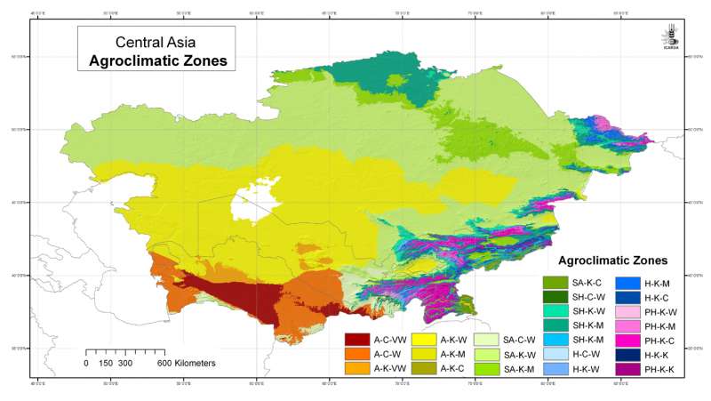
Central Asia: Agroclimatic Zones
Agroclimatic Zones for Central Asia at 30 arc-second ( about 1 km) resolution
Metadataclose[x]
Central Asia: Agroclimatic Zones
To provide a synthesis of location-specific climatic conditions using a climatic classification system
Agroclimatic Zones for Central Asia at 30 arc-second ( about 1 km) resolution
International Center for Agricultural Research in the Dry Areas (ICARDA)
2008
climate, climate classification, arid zones, UNESCO
Central Asia, Tajikistan, Turkmenistan, Kazakhstan, Uzbekistan, Kyrgyzstan
46.491856
87.315223
55.431949
35.141094
D_WGS_1984
WGS_1984
6378137.000000
298.257224

Central Asia: Annual Aridity Index
Annual Aridity Index for Central Asia at 30 arc-second ( about 1 km) resolution
Metadataclose[x]
Central Asia: Annual Aridity Index
To provide a measure of aridity for specific locations using an index
Annual Aridity Index for Central Asia at 30 arc-second ( about 1 km) resolution
International Center for Agricultural Research in the Dry Areas (ICARDA)
2008
climate, aridity index, arid zones, UNESCO
Central Asia, Tajikistan, Turkmenistan, Kazakhstan, Uzbekistan, Kyrgyzstan
46.491856
87.308524
55.424429
35.141094
D_WGS_1984
WGS_1984
6378137.000000
298.257224
")
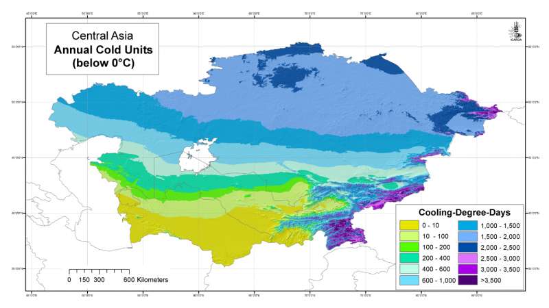
Central Asia: Annual Cold Units (below 0���������������°C)
Annual Cold Units grid for Central Asia at 30 arc-second ( about 1 km) resolution
Metadataclose[x]
Central Asia: Annual Cold Units (below 0���������������°C)
Developed for geospatial applications that require location-specific climatic information in places where no nearby climatic station exists
Annual Cold Units grid for Central Asia at 30 arc-second ( about 1 km) resolution
International Center for Agricultural Research in the Dry Areas (ICARDA)
2008
climate, temperature, cooling degree days
Central Asia, Tajikistan, Turkmenistan, Kazakhstan, Uzbekistan, Kyrgyzstan
46.491856
87.315223
55.431949
35.141094
D_WGS_1984
WGS_1984
6378137.000000
298.257224
")
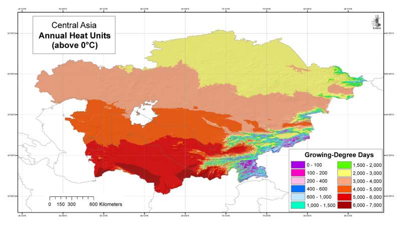
Central Asia: Annual Heat Units (above 0���������������°C)
Annual Heat Units grid for Central Asia at 30 arc-second ( about 1 km) resolution
Metadataclose[x]
Central Asia: Annual Heat Units (above 0���������������°C)
Developed for geospatial applications that require location-specific climatic information in places where no nearby climatic station exists
Annual Heat Units grid for Central Asia at 30 arc-second ( about 1 km) resolution
International Center for Agricultural Research in the Dry Areas (ICARDA)
2008
climate, temperature, heat units, growing degree days
Central Asia, Tajikistan, Turkmenistan, Kazakhstan, Uzbekistan, Kyrgyzstan
46.491856
87.315223
55.431949
35.141094
D_WGS_1984
WGS_1984
6378137.000000
298.257224

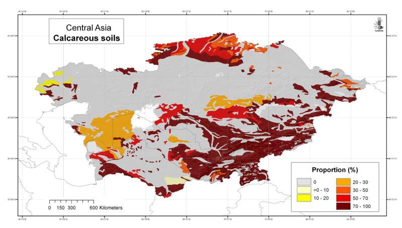
Central Asia: calcareous soils
Likelihood of the occurrence of calcareous (basic) soils in Central Asia at 30 arc-second ( about 1 km) resolution, derived from the FAO Soil Map of the World
Metadataclose[x]
Central Asia: calcareous soils
Derived soil properties give an indication of soil management properties and are useful for biodiversity assesment
Likelihood of the occurrence of calcareous (basic) soils in Central Asia at 30 arc-second ( about 1 km) resolution, derived from the FAO Soil Map of the World
International Center for Agricultural Research in the Dry Areas (ICARDA)
2008
soils, FAO, calcareous soils
Central Asia, Tajikistan, Turkmenistan, Kazakhstan, Uzbekistan, Kyrgyzstan
46.491856
87.308524
55.432762
35.141094
D_WGS_1984
WGS_1984
6378137.000000
298.257224
.")
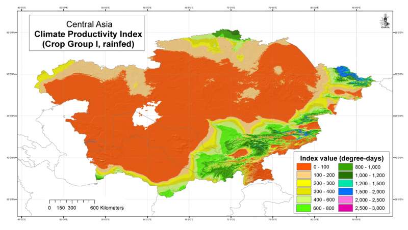
Central Asia: Climate Productivity Index (Crop Group I, rainfed).
Climate Productivity Index (Crop Group I, rainfed).
Metadataclose[x]
Central Asia: Climate Productivity Index (Crop Group I, rainfed).
REQUIRED: A summary of the intentions with which the data set was developed.
Climate Productivity Index (Crop Group I, rainfed).
International Center for Agricultural Research in the Dry Areas (ICARDA)
2008
climate
Central Asia
46.491856
87.308524
55.424429
35.141094
D_WGS_1984
WGS_1984
6378137.000000
298.257224
Central Asia: Climate Productivity Index (Crop Group II, rainfed).
Climate Productivity Index (Crop Group II, rainfed).
Metadataclose[x]
Central Asia: Climate Productivity Index (Crop Group II, rainfed).
REQUIRED: A summary of the intentions with which the data set was developed.
Climate Productivity Index (Crop Group II, rainfed).
International Center for Agricultural Research in the Dry Areas (ICARDA)
2008
climate
Central Asia
46.491856
87.308524
55.424429
35.141094
D_WGS_1984
WGS_1984
6378137.000000
298.257224
Central Asia: Climate Productivity Index (Crop Group III, rainfed).
Climate Productivity Index (Crop Group III, rainfed).
Metadataclose[x]
Central Asia: Climate Productivity Index (Crop Group III, rainfed).
REQUIRED: A summary of the intentions with which the data set was developed.
Climate Productivity Index (Crop Group III, rainfed).
International Center for Agricultural Research in the Dry Areas (ICARDA)
2008
climate
Central Asia
46.491856
87.308524
55.424429
35.141094
D_WGS_1984
WGS_1984
6378137.000000
298.257224
Central Asia: Climate Productivity Index (Crop Group IV, rainfed).
Climate Productivity Index (Crop Group IV, rainfed).
Metadataclose[x]
Central Asia: Climate Productivity Index (Crop Group IV, rainfed).
REQUIRED: A summary of the intentions with which the data set was developed.
Climate Productivity Index (Crop Group IV, rainfed).
International Center for Agricultural Research in the Dry Areas (ICARDA)
2008
climate
Central Asia
46.491856
87.308524
55.424429
35.141094
D_WGS_1984
WGS_1984
6378137.000000
298.257224