


Geoinformatics Solutions for Integrated Agro-ecosystems Research
GIS Data
Maps in: Agro-Ecological Zoning

Metadataclose[x]
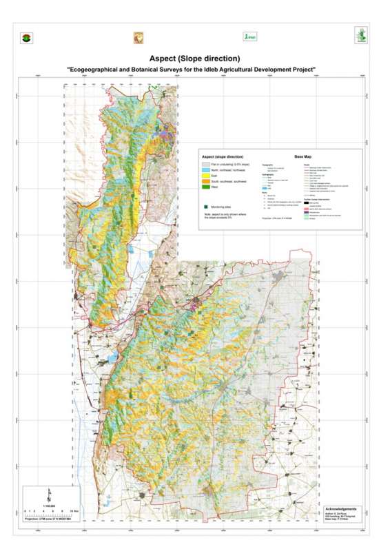
Jebel Zawia: Aspect
Characterisation of the agricultural environment in Jebel Zawia and in Jebel Wastani with a view to develop management plans for areas with valuable plant biodiversity (Idleb Rural Development Project)
Slope direction the Jebel Zawia area.
International Center for Agricultural Research in the Dry Areas (ICARDA)
2008
slope, aspect, direction
Syria, Idleb, Zawia
36.381926
36.900061
35.901056
35.377164
D_WGS_1984
WGS_1984
6378137.000000
298.257224

Metadataclose[x]
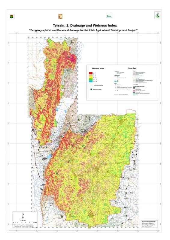
Jebel Zawia: Drainage
Characterisation of the agricultural environment in Jebel Zawia and in Jebel Wastani with a view to develop management plans for areas with valuable plant biodiversity (Idleb Rural Development Project)
Drainage network (streamlines) in the Jebel Zawia area
International Center for Agricultural Research in the Dry Areas (ICARDA)
2008
hydrology, drainage, streamlines
Syria, Idleb, Zawia
36.314106
36.928177
35.901522
35.378598
D_WGS_1984
WGS_1984
6378137.000000
298.257224

Metadataclose[x]
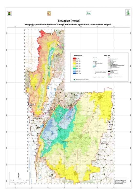
Jebel Zawia: Elevation
Characterisation of the agricultural environment in Jebel Zawia and in Jebel Wastani with a view to develop management plans for areas with valuable plant biodiversity (Idleb Rural Development Project)
Elevation map of the Jebel Zawia area.
International Center for Agricultural Research in the Dry Areas (ICARDA)
2008
elevation
Syria, Idleb, Zawia
36.381926
36.900061
35.901056
35.377164
D_WGS_1984
WGS_1984
6378137.000000
298.257224

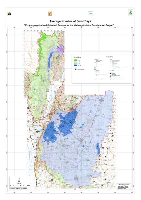
Jebel Zawia: Frost Days
Average number of frost days per year in the Jebel Zawia area.
Metadataclose[x]
Jebel Zawia: Frost Days
Characterisation of the agricultural environment in Jebel Zawia and in Jebel Wastani with a view to develop management plans for areas with valuable plant biodiversity (Idleb Rural Development Project)
Average number of frost days per year in the Jebel Zawia area.
International Center for Agricultural Research in the Dry Areas (ICARDA)
2008
climate, frost days
Syria, Idleb, Zawia
36.376094
36.902778
35.928907
35.372429
D_WGS_1984
WGS_1984
6378137.000000
298.257224

Jebel Zawia: Geology
Geological map the Jebel Zawia area extracted from the Technoexport geological map 1:200,000.
Metadataclose[x]
Jebel Zawia: Geology
Characterisation of the agricultural environment in Jebel Zawia and in Jebel Wastani with a view to develop management plans for areas with valuable plant biodiversity (Idleb Rural Development Project)
Geological map the Jebel Zawia area extracted from the Technoexport geological map 1:200,000.
International Center for Agricultural Research in the Dry Areas (ICARDA)
2008
geology, lithology
Syria, Idleb, Zawia
36.381351
36.900066
35.919029
35.377233
D_WGS_1984
WGS_1984
6378137.000000
298.257224

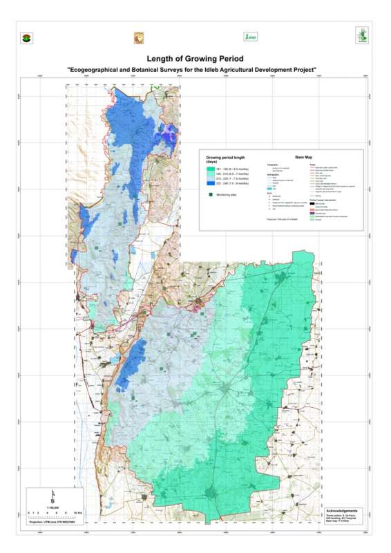
Jebel Zawia: Growing Period
Length of the growing perion in the Jebel Zawia area.
Metadataclose[x]
Jebel Zawia: Growing Period
Characterisation of the agricultural environment in Jebel Zawia and in Jebel Wastani with a view to develop management plans for areas with valuable plant biodiversity (Idleb Rural Development Project)
Length of the growing perion in the Jebel Zawia area.
International Center for Agricultural Research in the Dry Areas (ICARDA)
2008
climate, growing period
Syria, Idleb, Zawia
36.376094
36.902778
35.928907
35.372429
D_WGS_1984
WGS_1984
6378137.000000
298.257224

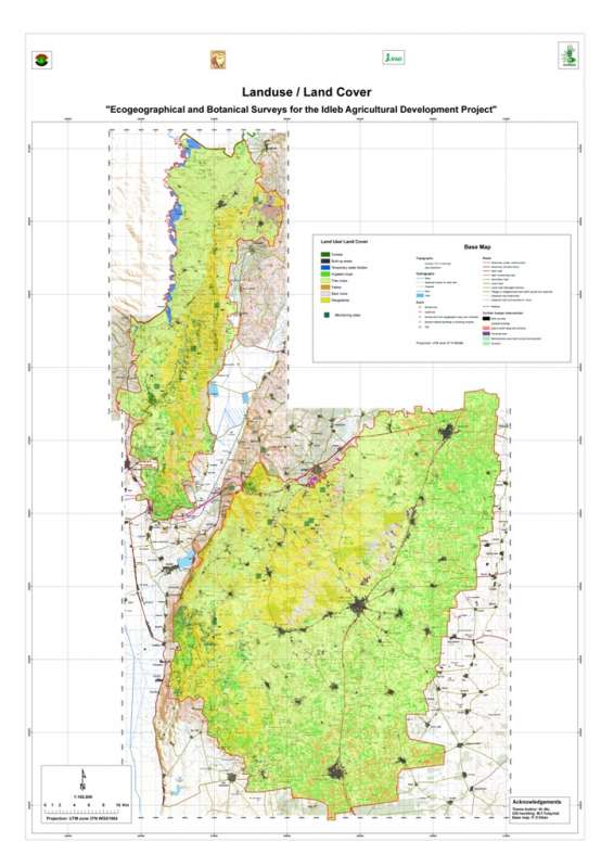
Jebel Zawia: Land Use/Land Cover
Land use/land cover map for the Jebel Zawia area. The survey was undertaken through image classification procedures using recent (2003) Landsat ETM+ imagery and ENVI software, and covered the entire Idleb Governorate.
Metadataclose[x]
Jebel Zawia: Land Use/Land Cover
Characterisation of the agricultural environment in Jebel Zawia and in Jebel Wastani with a view to develop management plans for areas with valuable plant biodiversity (Idleb Rural Development Project)
Land use/land cover map for the Jebel Zawia area. The survey was undertaken through image classification procedures using recent (2003) Landsat ETM+ imagery and ENVI software, and covered the entire Idleb Governorate.
International Center for Agricultural Research in the Dry Areas (ICARDA)
2008
land use, land cover
Syria, Idleb, Zawia
36.381329
36.899951
35.919164
35.377164
D_WGS_1984
WGS_1984
6378137.000000
298.257224

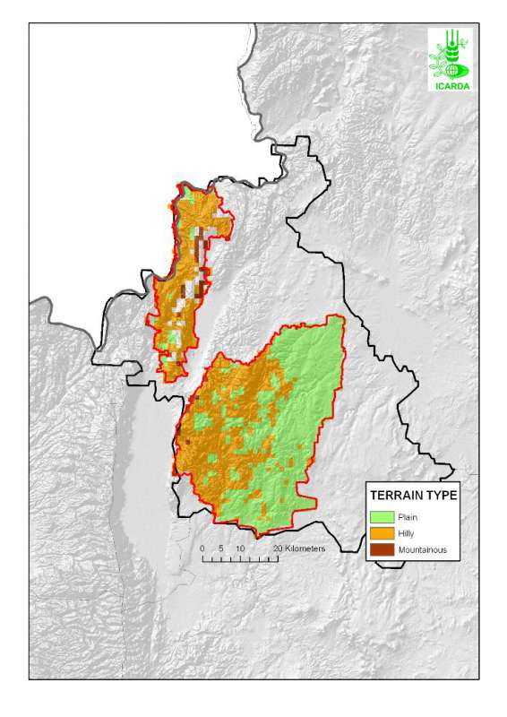
Jebel Zawia: Landfoms
Terrain classification (plain, hilly, mountainous) in the Jebel Zawia area.
Metadataclose[x]
Jebel Zawia: Landfoms
Characterisation of the agricultural environment in Jebel Zawia and in Jebel Wastani with a view to develop management plans for areas with valuable plant biodiversity (Idleb Rural Development Project)
Terrain classification (plain, hilly, mountainous) in the Jebel Zawia area.
International Center for Agricultural Research in the Dry Areas (ICARDA)
2008
terrain, landforms
Syria, Idleb, Zawia
36.376075
36.917746
35.929736
35.372488
D_WGS_1984
WGS_1984
6378137.000000
298.257224

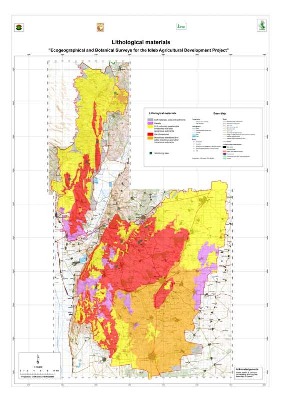
Jebel Zawia: Lithology
Lithology of the Jebel Zawia area based on a reclassification of the Technoexport geological map 1:200,000.
Metadataclose[x]
Jebel Zawia: Lithology
Characterisation of the agricultural environment in Jebel Zawia and in Jebel Wastani with a view to develop management plans for areas with valuable plant biodiversity (Idleb Rural Development Project)
Lithology of the Jebel Zawia area based on a reclassification of the Technoexport geological map 1:200,000.
International Center for Agricultural Research in the Dry Areas (ICARDA)
2008
geology, lithology
Syria, Idleb, Zawia
36.381333
36.900059
35.919054
35.377232
D_WGS_1984
WGS_1984
6378137.000000
298.257224

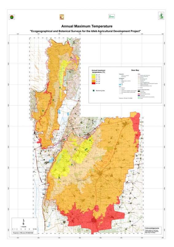
Jebel Zawia: Maximum Temperature
Average maximum temperature in the Jebel Zawia area
Metadataclose[x]
Jebel Zawia: Maximum Temperature
Characterisation of the agricultural environment in Jebel Zawia and in Jebel Wastani with a view to develop management plans for areas with valuable plant biodiversity (Idleb Rural Development Project)
Average maximum temperature in the Jebel Zawia area
International Center for Agricultural Research in the Dry Areas (ICARDA)
2008
climate, maximum temperature
Syria, Idleb, Zawia
36.376094
36.902778
35.928907
35.372429
D_WGS_1984
WGS_1984
6378137.000000
298.257224