


Geoinformatics Solutions for Integrated Agro-ecosystems Research
GIS Data
Maps in: Agro-Ecological Zoning

Metadataclose[x]
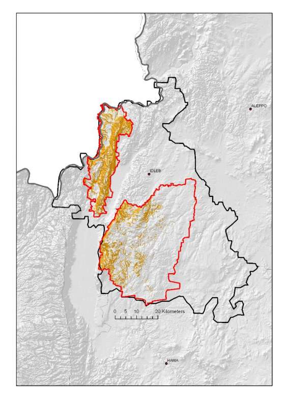
Jebel Zawia: Steepest Slopes
Characterisation of the agricultural environment in Jebel Zawia and in Jebel Wastani with a view to develop management plans for areas with valuable plant biodiversity (Idleb Rural Development Project)
Slopes higher than 12% in the Jebel Zawia area.
International Center for Agricultural Research in the Dry Areas (ICARDA)
2008
slope
Syria, Idleb, Zawia
36.381926
36.900061
35.901056
35.377164
D_WGS_1984
WGS_1984
6378137.000000
298.257224

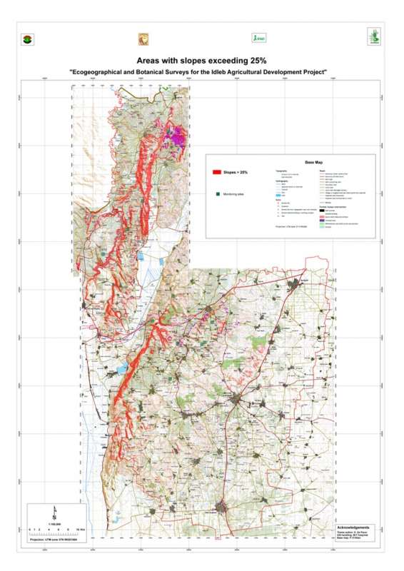
Jebel Wastani: Steep Slopes
Areas with slopes exceeding 25% in the Jebel Wastani area.
Metadataclose[x]
Jebel Wastani: Steep Slopes
Characterisation of the agricultural environment in Jebel Zawia and in Jebel Wastani with a view to develop management plans for areas with valuable plant biodiversity (Idleb Rural Development Project)
Areas with slopes exceeding 25% in the Jebel Wastani area.
International Center for Agricultural Research in the Dry Areas (ICARDA)
2008
slope
Syria, Idleb, Wastani
36.291735
36.563832
36.228515
35.744568
D_WGS_1984
WGS_1984
6378137.000000
298.257224
Jebel Zawia: Steep Slopes
Areas with slopes exceeding 25% in the Jebel Zawia area.
Metadataclose[x]
Jebel Zawia: Steep Slopes
Characterisation of the agricultural environment in Jebel Zawia and in Jebel Wastani with a view to develop management plans for areas with valuable plant biodiversity (Idleb Rural Development Project)
Areas with slopes exceeding 25% in the Jebel Zawia area.
International Center for Agricultural Research in the Dry Areas (ICARDA)
2008
slope
Syria, Idleb, Zawia
36.381926
36.900061
35.901056
35.377164
D_WGS_1984
WGS_1984
6378137.000000
298.257224

Metadataclose[x]
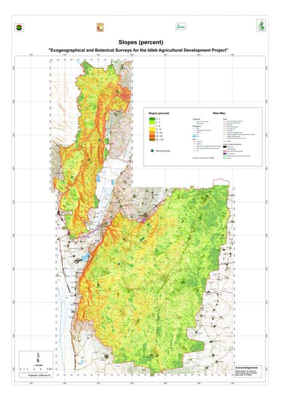
Jebel Wastani: Slopes
Characterisation of the agricultural environment in Jebel Zawia and in Jebel Wastani with a view to develop management plans for areas with valuable plant biodiversity (Idleb Rural Development Project)
Slopes in the Jebel Wastani area.
International Center for Agricultural Research in the Dry Areas (ICARDA)
2008
slope
Syria, Idleb, Wastani
36.291735
36.563832
36.228515
35.744568
D_WGS_1984
WGS_1984
6378137.000000
298.257224
Metadataclose[x]
Jebel Zawia: Slopes
Characterisation of the agricultural environment in Jebel Zawia and in Jebel Wastani with a view to develop management plans for areas with valuable plant biodiversity (Idleb Rural Development Project)
Slopes in the Jebel Zawia area.
International Center for Agricultural Research in the Dry Areas (ICARDA)
2008
slope
Syria, Idleb, Zawia
36.381926
36.900061
35.901056
35.377164
D_WGS_1984
WGS_1984
6378137.000000
298.257224

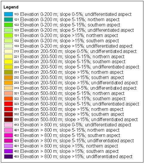
Jebel Wastani: Terrain
Terrain units the Jebel Wastani area. Terrain units are determined by combination of elevation, slope and aspect.
Metadataclose[x]
Jebel Wastani: Terrain
Characterisation of the agricultural environment in Jebel Zawia and in Jebel Wastani with a view to develop management plans for areas with valuable plant biodiversity (Idleb Rural Development Project)
Terrain units the Jebel Wastani area. Terrain units are determined by combination of elevation, slope and aspect.
International Center for Agricultural Research in the Dry Areas (ICARDA)
2008
slope, aspect, elevation, terrain
Syria, Idleb, Wastani
36.291735
36.563832
36.228515
35.744568
D_WGS_1984
WGS_1984
6378137.000000
298.257224
Jebel Zawia: Terrain
Terrain units the Jebel Zawia area. Terrain units are determined by combination of elevation, slope and aspect.
Metadataclose[x]
Jebel Zawia: Terrain
Characterisation of the agricultural environment in Jebel Zawia and in Jebel Wastani with a view to develop management plans for areas with valuable plant biodiversity (Idleb Rural Development Project)
Terrain units the Jebel Zawia area. Terrain units are determined by combination of elevation, slope and aspect.
International Center for Agricultural Research in the Dry Areas (ICARDA)
2008
slope, aspect, elevation, terrain
Syria, Idleb, Zawia
36.381926
36.900061
35.901056
35.377164
D_WGS_1984
WGS_1984
6378137.000000
298.257224

Jebel Wastani: Maximum Temperature
Average maximum temperature in the Jebel Wastani area
Metadataclose[x]
Jebel Wastani: Maximum Temperature
Characterisation of the agricultural environment in Jebel Zawia and in Jebel Wastani with a view to develop management plans for areas with valuable plant biodiversity (Idleb Rural Development Project)
Average maximum temperature in the Jebel Wastani area
International Center for Agricultural Research in the Dry Areas (ICARDA)
2008
climate, maximum temperature
Syria, Idleb, Wastani
36.286639
36.566675
36.230450
35.740842
D_WGS_1984
WGS_1984
6378137.000000
298.257224
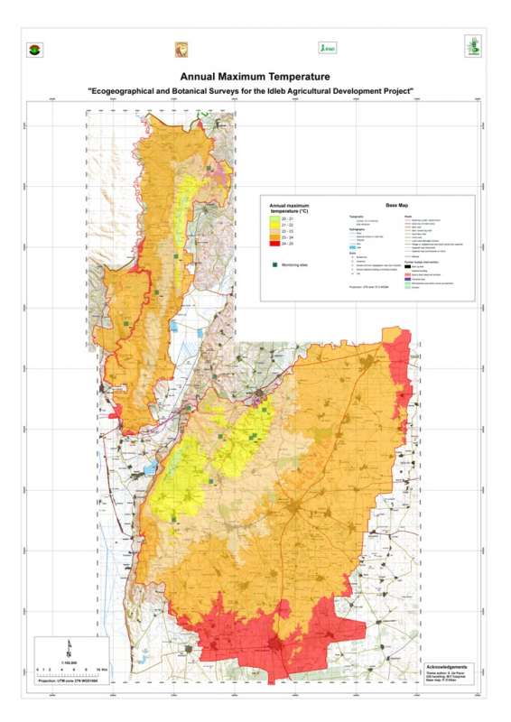
Jebel Zawia: Maximum Temperature
Average maximum temperature in the Jebel Zawia area
Metadataclose[x]
Jebel Zawia: Maximum Temperature
Characterisation of the agricultural environment in Jebel Zawia and in Jebel Wastani with a view to develop management plans for areas with valuable plant biodiversity (Idleb Rural Development Project)
Average maximum temperature in the Jebel Zawia area
International Center for Agricultural Research in the Dry Areas (ICARDA)
2008
climate, maximum temperature
Syria, Idleb, Zawia
36.376094
36.902778
35.928907
35.372429
D_WGS_1984
WGS_1984
6378137.000000
298.257224

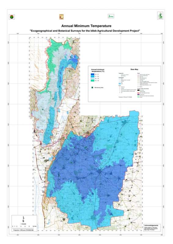
Jebel Wastani: Minimum Temperature
Average minimum temperature in the Jebel Wastani area
Metadataclose[x]
Jebel Wastani: Minimum Temperature
Characterisation of the agricultural environment in Jebel Zawia and in Jebel Wastani with a view to develop management plans for areas with valuable plant biodiversity (Idleb Rural Development Project)
Average minimum temperature in the Jebel Wastani area
International Center for Agricultural Research in the Dry Areas (ICARDA)
2008
climate, minimum temperature
Syria, Idleb, Wastani
36.286639
36.566675
36.230450
35.740842
D_WGS_1984
WGS_1984
6378137.000000
298.257224