


Geoinformatics Solutions for Integrated Agro-ecosystems Research
GIS Data
Maps in: Agro-Ecological Zoning

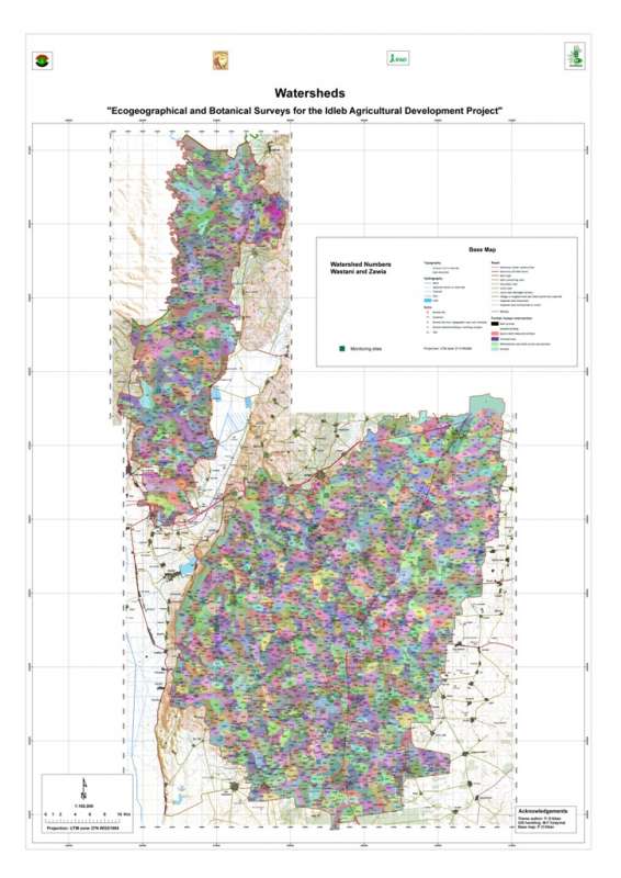
Jebel Zawia: Watersheds
Micro-watersheds (few square km) in the Jebel Zawia area
Metadataclose[x]
Jebel Zawia: Watersheds
Characterisation of the agricultural environment in Jebel Zawia and in Jebel Wastani with a view to develop management plans for areas with valuable plant biodiversity (Idleb Rural Development Project)
Micro-watersheds (few square km) in the Jebel Zawia area
International Center for Agricultural Research in the Dry Areas (ICARDA)
2008
hydrology, watersheds, catchment area
Syria, Idleb, Zawia
36.381332
36.900068
35.919074
35.377151
D_WGS_1984
WGS_1984
6378137.000000
298.257224

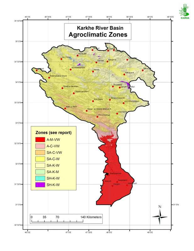
Agroclimatic Zones in Karkheh River Basin
Agroclimatic zones in Karkheh river basin
Metadataclose[x]
Agroclimatic Zones in Karkheh River Basin
Generate an agro-ecological zones map for the Karkheh River Basin along with land use/land cover and soil/landforms layers.
Agroclimatic zones in Karkheh river basin
International Center for Agricultural Research in the Dry Areas (ICARDA)
2008
agroclimatic zones
Iran, Karkheh river basin
46.100529
49.162195
34.960947
30.953447
D_WGS_1984
WGS_1984
6378137.000000
298.257224

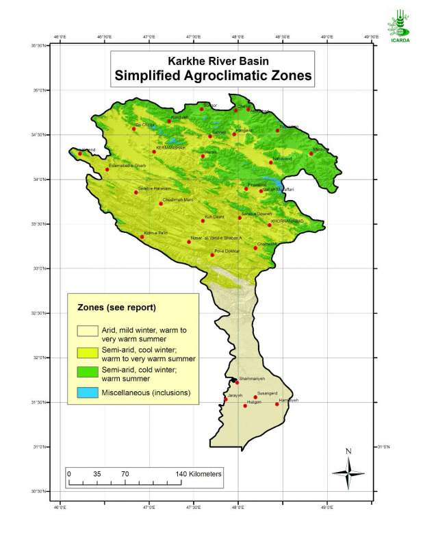
Simplified agroclimatic zones in Karkheh river basin
Simplified Agroclimatic Zones in Karkheh River Basin
Metadataclose[x]
Simplified agroclimatic zones in Karkheh river basin
Generate an agro-ecological zones map for the Karkheh river basin along with land use/land cover and soil/landforms layers.
Simplified Agroclimatic Zones in Karkheh River Basin
International Center for Agricultural Research in the Dry Areas (ICARDA)
2008
simplified agroclimatic zones
Iran, Karkheh river basin
46.100529
49.162195
34.960947
30.953447
D_WGS_1984
WGS_1984
6378137.000000
298.257224

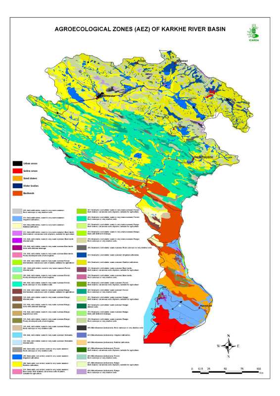
Agro-Ecological Zones in Karheh River Basin
Agro-ecological zones in Karkheh river basin
Metadataclose[x]
Agro-Ecological Zones in Karheh River Basin
Characterization of the agricultural environments in the Karkheh river basin based on water availability, climate, terrain and soil conditions.
Agro-ecological zones in Karkheh river basin
International Center for Agricultural Research in the Dry Areas (ICARDA)
2008
agro-ecological zones, agricultural environments
Iran, Karkheh river basin
46.104568
49.164568
34.953779
30.968779
D_WGS_1984
WGS_1984
6378137.000000
298.257224

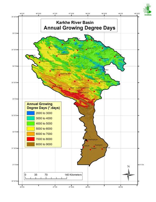
Annual Growing Degree Days in Karkheh River Basin
Annual growing degree-days in Karkheh river basin
Metadataclose[x]
Annual Growing Degree Days in Karkheh River Basin
Characterisation of agricultural climates of the Karkheh River Basin
Annual growing degree-days in Karkheh river basin
International Center for Agricultural Research in the Dry Areas (ICARDA)
2008
annual growing degree days, agricultural climates
Iran, Karkheh river basin
46.100529
49.162195
34.960947
30.953447
D_WGS_1984
WGS_1984
6378137.000000
298.257224

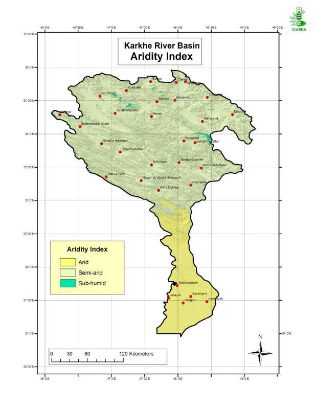
Aridity index in Karkheh river basin
Aridity Index in the Karkheh River Basin
Metadataclose[x]
Aridity index in Karkheh river basin
Determination of the moisture regime in the Karkheh river basin
Aridity Index in the Karkheh River Basin
International Center for Agricultural Research in the Dry Areas (ICARDA)
2008
aridity index, moisture regime, agroclimatic zones
Iran, Karkheh river basin
46.100529
49.162195
34.960947
30.953447
D_WGS_1984
WGS_1984
6378137.000000
298.257224

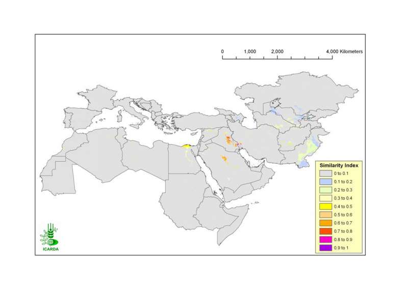
Similarity of CWANA and Northern Mediterranean in Climate, Land Use/Land Cover and Landforms to the Azadegan Benchmark Site
Similarity of CWANA (Central and West Asia and North Africa) and Northern Mediterranean in climate, land use/land cover and landform to the Azadegan benchmark site. The biophysical characterisation of benchmark sites is entirely derived from agro-ecological zones, landforms, land use/land cover and soils maps.
Metadataclose[x]
Similarity of CWANA and Northern Mediterranean in Climate, Land Use/Land Cover and Landforms to the Azadegan Benchmark Site
Assess the Azadegan benchmark site representativeness of the broader agro-ecological zones of CWANA and Northern Mediterranean
Similarity of CWANA (Central and West Asia and North Africa) and Northern Mediterranean in climate, land use/land cover and landform to the Azadegan benchmark site. The biophysical characterisation of benchmark sites is entirely derived from agro-ecological zones, landforms, land use/land cover and soils maps.
International Center for Agricultural Research in the Dry Areas (ICARDA)
2008
similarity index, climate, land use land cover, landforms, benchmark site
Iran, Karkheh river basin, Azadegan, CWANA
46.100529
49.162195
34.960947
30.953447
D_WGS_1984
WGS_1984
6378137.000000
298.257224

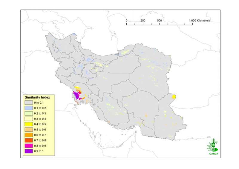
Similarity of Iran in Climate, Land Use/Land Cover and Landforms to the Azadegan Benchmark Site
Similarity of Iran in climate, land use/land cover and landform to the Azadegan benchmark site. The biophysical characterisation of benchmark sites is entirely derived from agro-ecological zones, landforms, land use/land cover and soils maps.
Metadataclose[x]
Similarity of Iran in Climate, Land Use/Land Cover and Landforms to the Azadegan Benchmark Site
Assess the Azadegan benchmark site representativeness of the broader agro-ecological zones of Iran
Similarity of Iran in climate, land use/land cover and landform to the Azadegan benchmark site. The biophysical characterisation of benchmark sites is entirely derived from agro-ecological zones, landforms, land use/land cover and soils maps.
International Center for Agricultural Research in the Dry Areas (ICARDA)
2008
similarity index, climate, land use land cover, landforms, benchmark site
Iran, Karkheh river basin, Azadegan
44.038776
63.313777
39.770641
25.070640
D_WGS_1984
WGS_1984
6378137.000000
298.257224

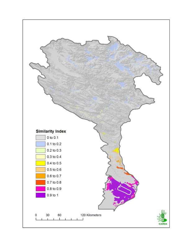
Similarity of KRB in Climate and Land Use/Land Cover to the Azadegan Benchmark Site
Similarity of KRB in climate and land use/land cover to the Azadegan benchmark site. The biophysical characterisation of benchmark sites is entirely derived from agro-ecological zones, landforms, land use/land cover and soils maps.
Metadataclose[x]
Similarity of KRB in Climate and Land Use/Land Cover to the Azadegan Benchmark Site
Assess the Azadegan benchmark site representativeness of the broader agro-ecological zones of Karkheh river basin
Similarity of KRB in climate and land use/land cover to the Azadegan benchmark site. The biophysical characterisation of benchmark sites is entirely derived from agro-ecological zones, landforms, land use/land cover and soils maps.
International Center for Agricultural Research in the Dry Areas (ICARDA)
2008
similarity index, climate, land use land cover, benchmark site
Iran, Karkheh river basin, Azadegan
46.100529
49.162195
34.960947
30.953447
D_WGS_1984
WGS_1984
6378137.000000
298.257224

Growing Period End in Karkheh River Basin
End month of the temperature- and moisture-limited growing period in Karkheh river basin
Metadataclose[x]
Growing Period End in Karkheh River Basin
Characterization of agricultural climates of the Karkheh River Basin
End month of the temperature- and moisture-limited growing period in Karkheh river basin
International Center for Agricultural Research in the Dry Areas (ICARDA)
2008
moisture- and temperature-limited growing period, growing period end month, agricultural climates
Iran, Karkheh river basin
46.100529
49.162195
34.960947
30.953447
D_WGS_1984
WGS_1984
6378137.000000
298.257224