


Geoinformatics Solutions for Integrated Agro-ecosystems Research
GIS Data
Maps in: Agro-Ecological Zoning

Jebel Wastani: Drainage
Drainage network (streamlines) in the Jebel Wastani area
Metadataclose[x]
Jebel Wastani: Drainage
Characterisation of the agricultural environment in Jebel Zawia and in Jebel Wastani with a view to develop management plans for areas with valuable plant biodiversity (Idleb Rural Development Project)
Drainage network (streamlines) in the Jebel Wastani area
International Center for Agricultural Research in the Dry Areas (ICARDA)
2008
hydrology, drainage, streamlines
Syria, Idleb, Wastani
36.289765
36.606037
36.243318
35.717470
D_WGS_1984
WGS_1984
6378137.000000
298.257224

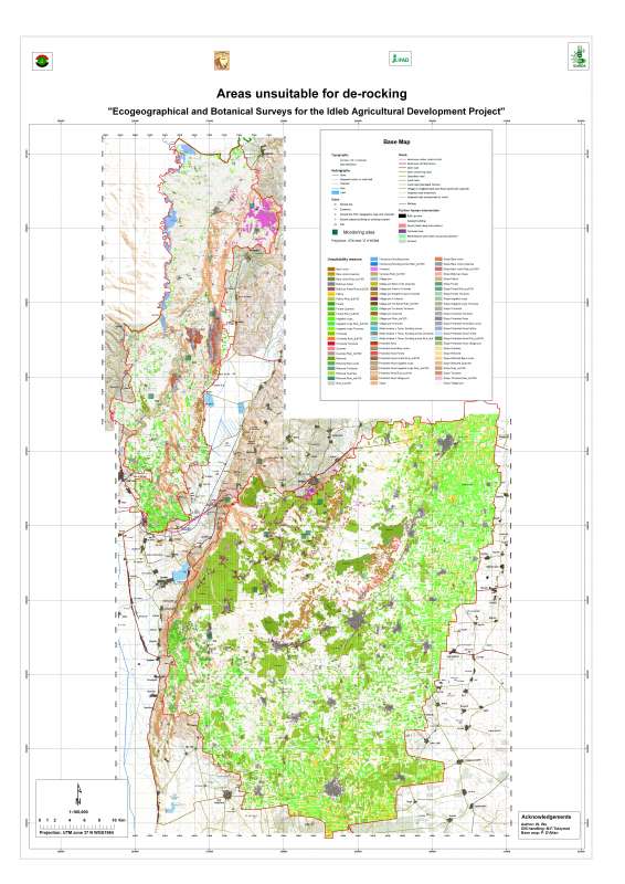
Jebel Wastani Area: Unsuitability for De-Rocking
Unsuitable zones for de-rocking farming system in Jebel Wastani area
Metadataclose[x]
Jebel Wastani Area: Unsuitability for De-Rocking
Characterisation of the agricultural environment in Jebel Zawia and in Jebel Wastani with a view to develop management plans for areas with valuable plant biodiversity (Idleb Rural Development Project)
Unsuitable zones for de-rocking farming system in Jebel Wastani area
International Center for Agricultural Research in the Dry Areas (ICARDA)
2008
de-rocking, land reclamation, rock removal
Syria, Idleb, Wastani
36.291599
36.563816
36.228634
35.744399
D_WGS_1984
WGS_1984
6378137.000000
298.257224
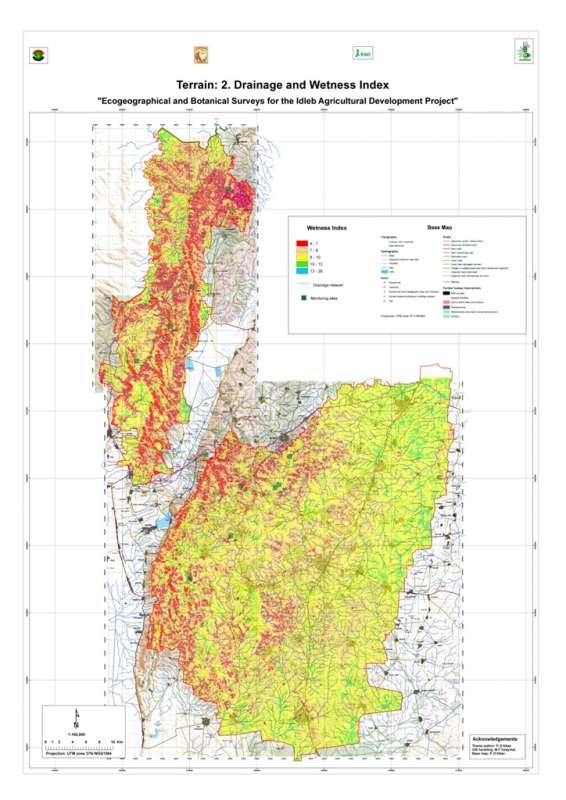
Jebel Wastani: Wetness Index
Wetness index (or compound topographic index) in the Jebel Wastani area. This index quantifies the position of a site in the local landscape, in terms of either run-on or run-off characteristics.
Metadataclose[x]
Jebel Wastani: Wetness Index
Characterisation of the agricultural environment in Jebel Zawia and in Jebel Wastani with a view to develop management plans for areas with valuable plant biodiversity (Idleb Rural Development Project)
Wetness index (or compound topographic index) in the Jebel Wastani area. This index quantifies the position of a site in the local landscape, in terms of either run-on or run-off characteristics.
International Center for Agricultural Research in the Dry Areas (ICARDA)
2008
Wetness index, topography, run-off
Syria, Idleb, Wastani
36.282496
36.606109
36.243322
35.717262
D_WGS_1984
WGS_1984
6378137.000000
298.257224

Jebel Zawia: Minimum Temperature
Average minimum temperature in the Jebel Zawia area
Metadataclose[x]
Jebel Zawia: Minimum Temperature
Characterisation of the agricultural environment in Jebel Zawia and in Jebel Wastani with a view to develop management plans for areas with valuable plant biodiversity (Idleb Rural Development Project)
Average minimum temperature in the Jebel Zawia area
International Center for Agricultural Research in the Dry Areas (ICARDA)
2008
climate, maximum temperature
Syria, Idleb, Zawia
36.376094
36.902778
35.928907
35.372429
D_WGS_1984
WGS_1984
6378137.000000
298.257224
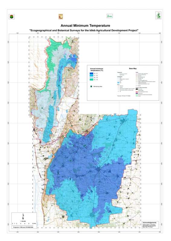
Jebel Wastani: Minimum Temperature
Average minimum temperature in the Jebel Wastani area
Metadataclose[x]
Jebel Wastani: Minimum Temperature
Characterisation of the agricultural environment in Jebel Zawia and in Jebel Wastani with a view to develop management plans for areas with valuable plant biodiversity (Idleb Rural Development Project)
Average minimum temperature in the Jebel Wastani area
International Center for Agricultural Research in the Dry Areas (ICARDA)
2008
climate, minimum temperature
Syria, Idleb, Wastani
36.286639
36.566675
36.230450
35.740842
D_WGS_1984
WGS_1984
6378137.000000
298.257224

Jebel Zawia: Maximum Temperature
Average maximum temperature in the Jebel Zawia area
Metadataclose[x]
Jebel Zawia: Maximum Temperature
Characterisation of the agricultural environment in Jebel Zawia and in Jebel Wastani with a view to develop management plans for areas with valuable plant biodiversity (Idleb Rural Development Project)
Average maximum temperature in the Jebel Zawia area
International Center for Agricultural Research in the Dry Areas (ICARDA)
2008
climate, maximum temperature
Syria, Idleb, Zawia
36.376094
36.902778
35.928907
35.372429
D_WGS_1984
WGS_1984
6378137.000000
298.257224
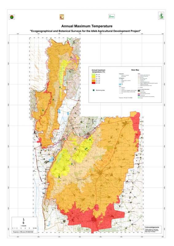
Jebel Wastani: Maximum Temperature
Average maximum temperature in the Jebel Wastani area
Metadataclose[x]
Jebel Wastani: Maximum Temperature
Characterisation of the agricultural environment in Jebel Zawia and in Jebel Wastani with a view to develop management plans for areas with valuable plant biodiversity (Idleb Rural Development Project)
Average maximum temperature in the Jebel Wastani area
International Center for Agricultural Research in the Dry Areas (ICARDA)
2008
climate, maximum temperature
Syria, Idleb, Wastani
36.286639
36.566675
36.230450
35.740842
D_WGS_1984
WGS_1984
6378137.000000
298.257224

Jebel Zawia: Terrain
Terrain units the Jebel Zawia area. Terrain units are determined by combination of elevation, slope and aspect.
Metadataclose[x]
Jebel Zawia: Terrain
Characterisation of the agricultural environment in Jebel Zawia and in Jebel Wastani with a view to develop management plans for areas with valuable plant biodiversity (Idleb Rural Development Project)
Terrain units the Jebel Zawia area. Terrain units are determined by combination of elevation, slope and aspect.
International Center for Agricultural Research in the Dry Areas (ICARDA)
2008
slope, aspect, elevation, terrain
Syria, Idleb, Zawia
36.381926
36.900061
35.901056
35.377164
D_WGS_1984
WGS_1984
6378137.000000
298.257224
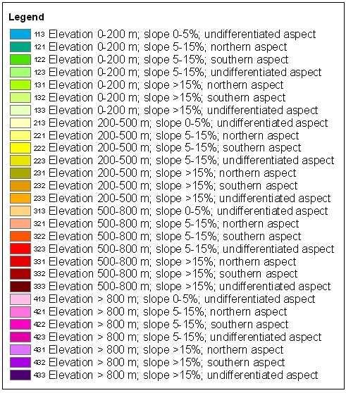
Jebel Wastani: Terrain
Terrain units the Jebel Wastani area. Terrain units are determined by combination of elevation, slope and aspect.
Metadataclose[x]
Jebel Wastani: Terrain
Characterisation of the agricultural environment in Jebel Zawia and in Jebel Wastani with a view to develop management plans for areas with valuable plant biodiversity (Idleb Rural Development Project)
Terrain units the Jebel Wastani area. Terrain units are determined by combination of elevation, slope and aspect.
International Center for Agricultural Research in the Dry Areas (ICARDA)
2008
slope, aspect, elevation, terrain
Syria, Idleb, Wastani
36.291735
36.563832
36.228515
35.744568
D_WGS_1984
WGS_1984
6378137.000000
298.257224

Metadataclose[x]
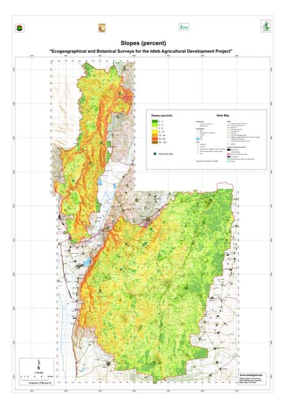
Jebel Zawia: Slopes
Characterisation of the agricultural environment in Jebel Zawia and in Jebel Wastani with a view to develop management plans for areas with valuable plant biodiversity (Idleb Rural Development Project)
Slopes in the Jebel Zawia area.
International Center for Agricultural Research in the Dry Areas (ICARDA)
2008
slope
Syria, Idleb, Zawia
36.381926
36.900061
35.901056
35.377164
D_WGS_1984
WGS_1984
6378137.000000
298.257224