


Geoinformatics Solutions for Integrated Agro-ecosystems Research
GIS Data
Maps in: Agro-Ecological Zoning

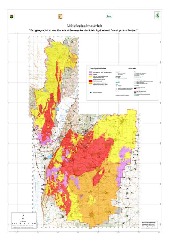
Jebel Wastani: Lithology
Lithology of the Jebel Wastani area based on a reclassification of the Technoexport geological map 1:200,000.
Metadataclose[x]
Jebel Wastani: Lithology
Characterisation of the agricultural environment in Jebel Zawia and in Jebel Wastani with a view to develop management plans for areas with valuable plant biodiversity (Idleb Rural Development Project)
Lithology of the Jebel Wastani area based on a reclassification of the Technoexport geological map 1:200,000.
International Center for Agricultural Research in the Dry Areas (ICARDA)
2008
geology, lithology
Syria, Idleb, Wastani
36.291735
36.563832
36.228515
35.744568
D_WGS_1984
WGS_1984
6378137.000000
298.257224

Jebel Zawia: Growing Period
Length of the growing perion in the Jebel Zawia area.
Metadataclose[x]
Jebel Zawia: Growing Period
Characterisation of the agricultural environment in Jebel Zawia and in Jebel Wastani with a view to develop management plans for areas with valuable plant biodiversity (Idleb Rural Development Project)
Length of the growing perion in the Jebel Zawia area.
International Center for Agricultural Research in the Dry Areas (ICARDA)
2008
climate, growing period
Syria, Idleb, Zawia
36.376094
36.902778
35.928907
35.372429
D_WGS_1984
WGS_1984
6378137.000000
298.257224
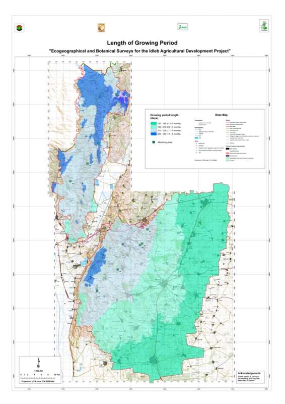
Jebel Wastani: Growing Period
Length of the growing perion in the Jebel Wastani area.
Metadataclose[x]
Jebel Wastani: Growing Period
Characterisation of the agricultural environment in Jebel Zawia and in Jebel Wastani with a view to develop management plans for areas with valuable plant biodiversity (Idleb Rural Development Project)
Length of the growing perion in the Jebel Wastani area.
International Center for Agricultural Research in the Dry Areas (ICARDA)
2008
climate, growing period
Syria, Idleb, Wastani
36.286639
36.566675
36.230450
35.740842
D_WGS_1984
WGS_1984
6378137.000000
298.257224

Jebel Zawia: Landfoms
Terrain classification (plain, hilly, mountainous) in the Jebel Zawia area.
Metadataclose[x]
Jebel Zawia: Landfoms
Characterisation of the agricultural environment in Jebel Zawia and in Jebel Wastani with a view to develop management plans for areas with valuable plant biodiversity (Idleb Rural Development Project)
Terrain classification (plain, hilly, mountainous) in the Jebel Zawia area.
International Center for Agricultural Research in the Dry Areas (ICARDA)
2008
terrain, landforms
Syria, Idleb, Zawia
36.376075
36.917746
35.929736
35.372488
D_WGS_1984
WGS_1984
6378137.000000
298.257224
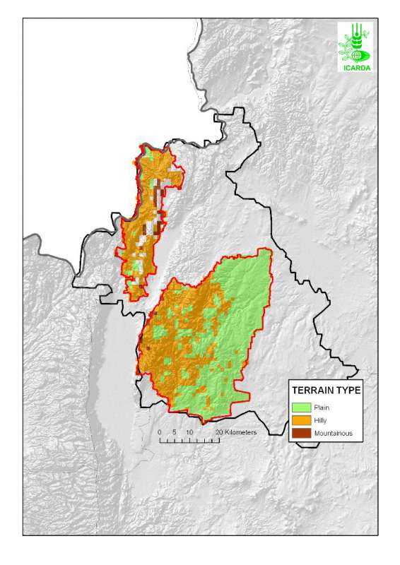
Jebel Wastani: Landfoms
Terrain classification (plain, hilly, mountainous) in the Jebel Wastani area.
Metadataclose[x]
Jebel Wastani: Landfoms
Characterisation of the agricultural environment in Jebel Zawia and in Jebel Wastani with a view to develop management plans for areas with valuable plant biodiversity (Idleb Rural Development Project)
Terrain classification (plain, hilly, mountainous) in the Jebel Wastani area.
International Center for Agricultural Research in the Dry Areas (ICARDA)
2008
terrain, landforms
Syria, Idleb, Wastani
36.286689
36.566237
36.229011
35.740825
D_WGS_1984
WGS_1984
6378137.000000
298.257224

Jebel Zawia: Frost Days
Average number of frost days per year in the Jebel Zawia area.
Metadataclose[x]
Jebel Zawia: Frost Days
Characterisation of the agricultural environment in Jebel Zawia and in Jebel Wastani with a view to develop management plans for areas with valuable plant biodiversity (Idleb Rural Development Project)
Average number of frost days per year in the Jebel Zawia area.
International Center for Agricultural Research in the Dry Areas (ICARDA)
2008
climate, frost days
Syria, Idleb, Zawia
36.376094
36.902778
35.928907
35.372429
D_WGS_1984
WGS_1984
6378137.000000
298.257224
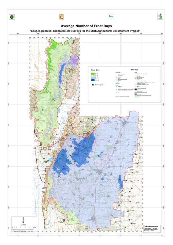
Jebel Wastani: Frost Days
Average number of frost days per year in the Jebel Wastani area.
Metadataclose[x]
Jebel Wastani: Frost Days
Characterisation of the agricultural environment in Jebel Zawia and in Jebel Wastani with a view to develop management plans for areas with valuable plant biodiversity (Idleb Rural Development Project)
Average number of frost days per year in the Jebel Wastani area.
International Center for Agricultural Research in the Dry Areas (ICARDA)
2008
climate, frost days
Syria, Idleb, Wastani
36.286639
36.566675
36.230450
35.740842
D_WGS_1984
WGS_1984
6378137.000000
298.257224

Metadataclose[x]
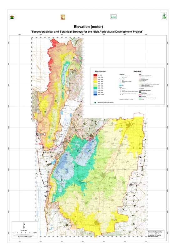
Jebel Zawia: Elevation
Characterisation of the agricultural environment in Jebel Zawia and in Jebel Wastani with a view to develop management plans for areas with valuable plant biodiversity (Idleb Rural Development Project)
Elevation map of the Jebel Zawia area.
International Center for Agricultural Research in the Dry Areas (ICARDA)
2008
elevation
Syria, Idleb, Zawia
36.381926
36.900061
35.901056
35.377164
D_WGS_1984
WGS_1984
6378137.000000
298.257224
Metadataclose[x]
Jebel Wastani: Elevation
Characterisation of the agricultural environment in Jebel Zawia and in Jebel Wastani with a view to develop management plans for areas with valuable plant biodiversity (Idleb Rural Development Project)
Elevation map of the Jebel Wastani area.
International Center for Agricultural Research in the Dry Areas (ICARDA)
2008
elevation
Syria, Idleb, Wastani
36.291735
36.563832
36.228515
35.744568
D_WGS_1984
WGS_1984
6378137.000000
298.257224

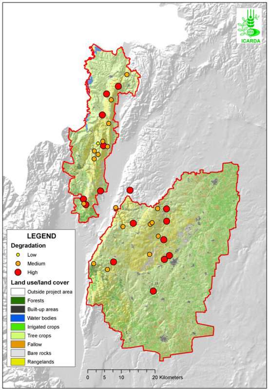
Idleb Rural Development Project Area: Vegetation Degradation
Level of vegetation degradation observed in Jebel Zawia and Jebel Wastani
Metadataclose[x]
Idleb Rural Development Project Area: Vegetation Degradation
Characterisation of the agricultural environment in Jebel Zawia and in Jebel Wastani with a view to develop management plans for areas with valuable plant biodiversity (Idleb Rural Development Project)
Level of vegetation degradation observed in Jebel Zawia and Jebel Wastani
International Center for Agricultural Research in the Dry Areas (ICARDA)
2008
vegetation, degradation
Syria, Idleb, Wastani, Zawia
36.364215
36.664777
36.148592
35.563753
D_WGS_1984
WGS_1984
6378137.000000
298.257224