


Geoinformatics Solutions for Integrated Agro-ecosystems Research
GIS Data
Maps in: Agro-Ecological Zoning

Agro-Ecological Zones in Karheh River Basin
Agro-ecological zones in Karkheh river basin
Metadataclose[x]
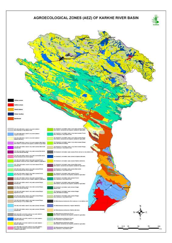
Agro-Ecological Zones in Karheh River Basin
Characterization of the agricultural environments in the Karkheh river basin based on water availability, climate, terrain and soil conditions.
Agro-ecological zones in Karkheh river basin
International Center for Agricultural Research in the Dry Areas (ICARDA)
2008
agro-ecological zones, agricultural environments
Iran, Karkheh river basin
46.104568
49.164568
34.953779
30.968779
D_WGS_1984
WGS_1984
6378137.000000
298.257224

Simplified agroclimatic zones in Karkheh river basin
Simplified Agroclimatic Zones in Karkheh River Basin
Metadataclose[x]
Simplified agroclimatic zones in Karkheh river basin
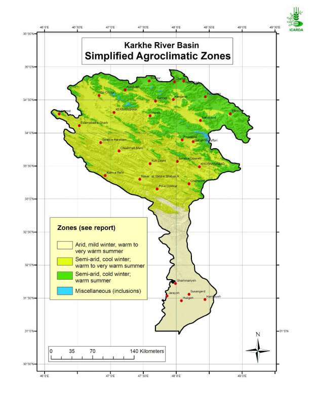
Generate an agro-ecological zones map for the Karkheh river basin along with land use/land cover and soil/landforms layers.
Simplified Agroclimatic Zones in Karkheh River Basin
International Center for Agricultural Research in the Dry Areas (ICARDA)
2008
simplified agroclimatic zones
Iran, Karkheh river basin
46.100529
49.162195
34.960947
30.953447
D_WGS_1984
WGS_1984
6378137.000000
298.257224

Agroclimatic Zones in Karkheh River Basin
Agroclimatic zones in Karkheh river basin
Metadataclose[x]
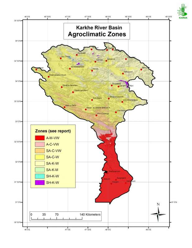
Agroclimatic Zones in Karkheh River Basin
Generate an agro-ecological zones map for the Karkheh River Basin along with land use/land cover and soil/landforms layers.
Agroclimatic zones in Karkheh river basin
International Center for Agricultural Research in the Dry Areas (ICARDA)
2008
agroclimatic zones
Iran, Karkheh river basin
46.100529
49.162195
34.960947
30.953447
D_WGS_1984
WGS_1984
6378137.000000
298.257224

Jebel Zawia: Watersheds
Micro-watersheds (few square km) in the Jebel Zawia area
Metadataclose[x]
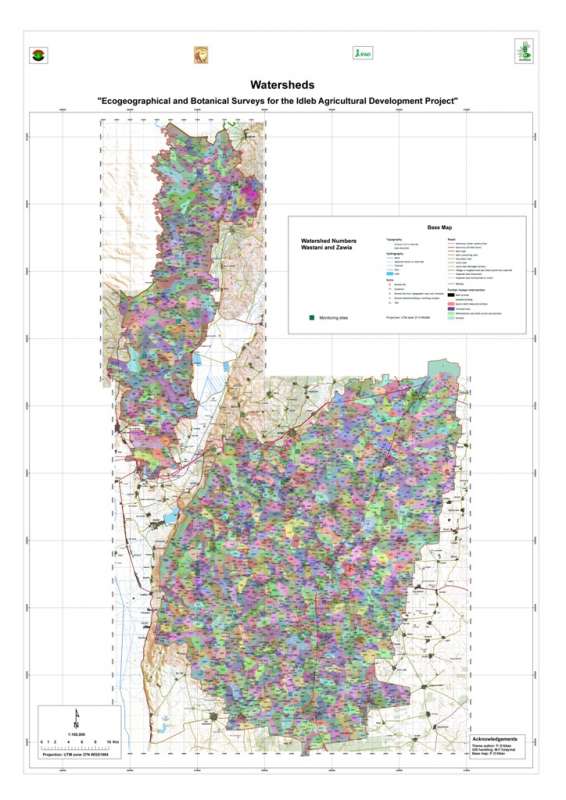
Jebel Zawia: Watersheds
Characterisation of the agricultural environment in Jebel Zawia and in Jebel Wastani with a view to develop management plans for areas with valuable plant biodiversity (Idleb Rural Development Project)
Micro-watersheds (few square km) in the Jebel Zawia area
International Center for Agricultural Research in the Dry Areas (ICARDA)
2008
hydrology, watersheds, catchment area
Syria, Idleb, Zawia
36.381332
36.900068
35.919074
35.377151
D_WGS_1984
WGS_1984
6378137.000000
298.257224

Jebel Zawia: Geology
Geological map the Jebel Zawia area extracted from the Technoexport geological map 1:200,000.
Metadataclose[x]
Jebel Zawia: Geology
Characterisation of the agricultural environment in Jebel Zawia and in Jebel Wastani with a view to develop management plans for areas with valuable plant biodiversity (Idleb Rural Development Project)
Geological map the Jebel Zawia area extracted from the Technoexport geological map 1:200,000.
International Center for Agricultural Research in the Dry Areas (ICARDA)
2008
geology, lithology
Syria, Idleb, Zawia
36.381351
36.900066
35.919029
35.377233
D_WGS_1984
WGS_1984
6378137.000000
298.257224

Metadataclose[x]
Jebel Zawia: Drainage
Characterisation of the agricultural environment in Jebel Zawia and in Jebel Wastani with a view to develop management plans for areas with valuable plant biodiversity (Idleb Rural Development Project)
Drainage network (streamlines) in the Jebel Zawia area
International Center for Agricultural Research in the Dry Areas (ICARDA)
2008
hydrology, drainage, streamlines
Syria, Idleb, Zawia
36.314106
36.928177
35.901522
35.378598
D_WGS_1984
WGS_1984
6378137.000000
298.257224

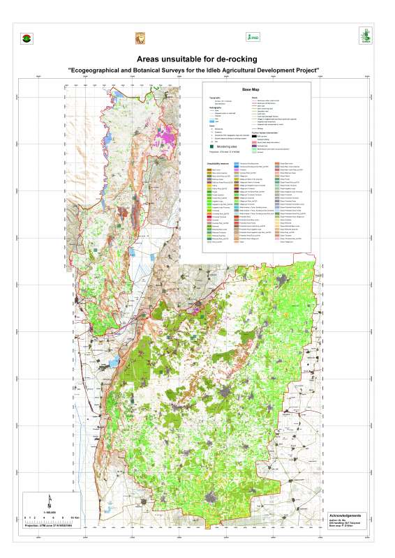
Jebel Zawia Area: Unsuitability for De-Rocking
Unsuitable zones for de-rocking farming system in Jebel Zawia areas
Metadataclose[x]
Jebel Zawia Area: Unsuitability for De-Rocking
Characterisation of the agricultural environment in Jebel Zawia and in Jebel Wastani with a view to develop management plans for areas with valuable plant biodiversity (Idleb Rural Development Project)
Unsuitable zones for de-rocking farming system in Jebel Zawia areas
International Center for Agricultural Research in the Dry Areas (ICARDA)
2008
de-rocking, land reclamation, rock removal
Syria, Idleb, Zawia
36.381890
36.900070
35.900989
35.377096
D_WGS_1984
WGS_1984
6378137.000000
298.257224
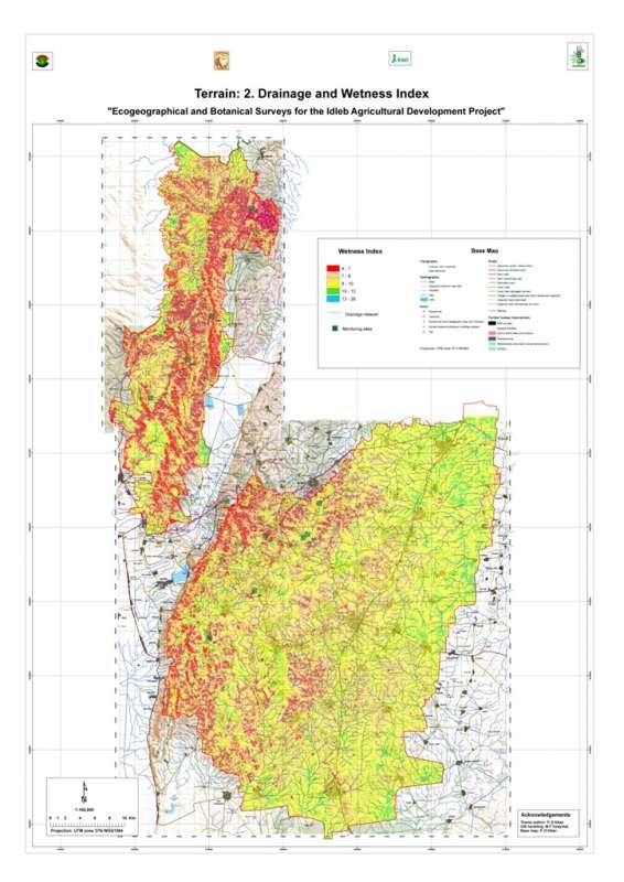
Jebel Zawia: Wetness Index
Wetness index (or compound topographic index) in the Jebel Zawia area. This index quantifies the position of a site in the local landscape, in terms of either run-on or run-off characteristics.
Metadataclose[x]
Jebel Zawia: Wetness Index
Characterisation of the agricultural environment in Jebel Zawia and in Jebel Wastani with a view to develop management plans for areas with valuable plant biodiversity (Idleb Rural Development Project)
Wetness index (or compound topographic index) in the Jebel Zawia area. This index quantifies the position of a site in the local landscape, in terms of either run-on or run-off characteristics.
International Center for Agricultural Research in the Dry Areas (ICARDA)
2008
Wetness index, topography, run-off
Syria, Idleb, Zawia
36.312311
36.928358
35.901540
35.375100
D_WGS_1984
WGS_1984
6378137.000000
298.257224
Jebel Wastani: Watersheds
Micro-watersheds (few square km) in the Jebel Wastani area
Metadataclose[x]
Jebel Wastani: Watersheds
Characterisation of the agricultural environment in Jebel Zawia and in Jebel Wastani with a view to develop management plans for areas with valuable plant biodiversity (Idleb Rural Development Project)
Micro-watersheds (few square km) in the Jebel Wastani area
International Center for Agricultural Research in the Dry Areas (ICARDA)
2008
hydrology, watersheds, catchment area
Syria, Idleb, Wastani
36.291734
36.563779
36.228547
35.744568
D_WGS_1984
WGS_1984
6378137.000000
298.257224
Jebel Wastani: Geology
Geological map the Jebel Wastani area extracted from the Technoexport geological map 1:200,000.
Metadataclose[x]
Jebel Wastani: Geology
Characterisation of the agricultural environment in Jebel Zawia and in Jebel Wastani with a view to develop management plans for areas with valuable plant biodiversity (Idleb Rural Development Project)
Geological map the Jebel Wastani area extracted from the Technoexport geological map 1:200,000.
International Center for Agricultural Research in the Dry Areas (ICARDA)
2008
geology, lithology
Syria, Idleb, Wastani
36.291734
36.563779
36.228547
35.744568
D_WGS_1984
WGS_1984
6378137.000000
298.257224