


Geoinformatics Solutions for Integrated Agro-ecosystems Research
GIS Data
Maps in: Agro-Ecological Zoning

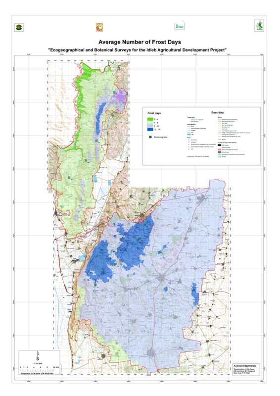
Jebel Wastani: Frost Days
Average number of frost days per year in the Jebel Wastani area.
Metadataclose[x]
Jebel Wastani: Frost Days
Characterisation of the agricultural environment in Jebel Zawia and in Jebel Wastani with a view to develop management plans for areas with valuable plant biodiversity (Idleb Rural Development Project)
Average number of frost days per year in the Jebel Wastani area.
International Center for Agricultural Research in the Dry Areas (ICARDA)
2008
climate, frost days
Syria, Idleb, Wastani
36.286639
36.566675
36.230450
35.740842
D_WGS_1984
WGS_1984
6378137.000000
298.257224

Metadataclose[x]
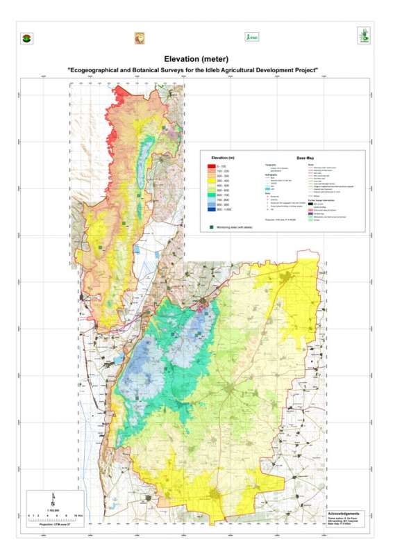
Jebel Wastani: Elevation
Characterisation of the agricultural environment in Jebel Zawia and in Jebel Wastani with a view to develop management plans for areas with valuable plant biodiversity (Idleb Rural Development Project)
Elevation map of the Jebel Wastani area.
International Center for Agricultural Research in the Dry Areas (ICARDA)
2008
elevation
Syria, Idleb, Wastani
36.291735
36.563832
36.228515
35.744568
D_WGS_1984
WGS_1984
6378137.000000
298.257224

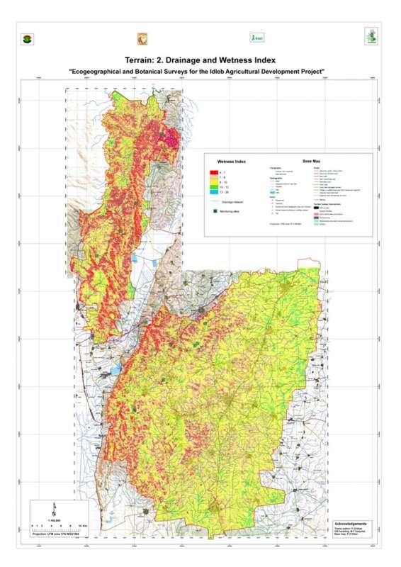
Jebel Wastani: Drainage
Drainage network (streamlines) in the Jebel Wastani area
Metadataclose[x]
Jebel Wastani: Drainage
Characterisation of the agricultural environment in Jebel Zawia and in Jebel Wastani with a view to develop management plans for areas with valuable plant biodiversity (Idleb Rural Development Project)
Drainage network (streamlines) in the Jebel Wastani area
International Center for Agricultural Research in the Dry Areas (ICARDA)
2008
hydrology, drainage, streamlines
Syria, Idleb, Wastani
36.289765
36.606037
36.243318
35.717470
D_WGS_1984
WGS_1984
6378137.000000
298.257224

Metadataclose[x]
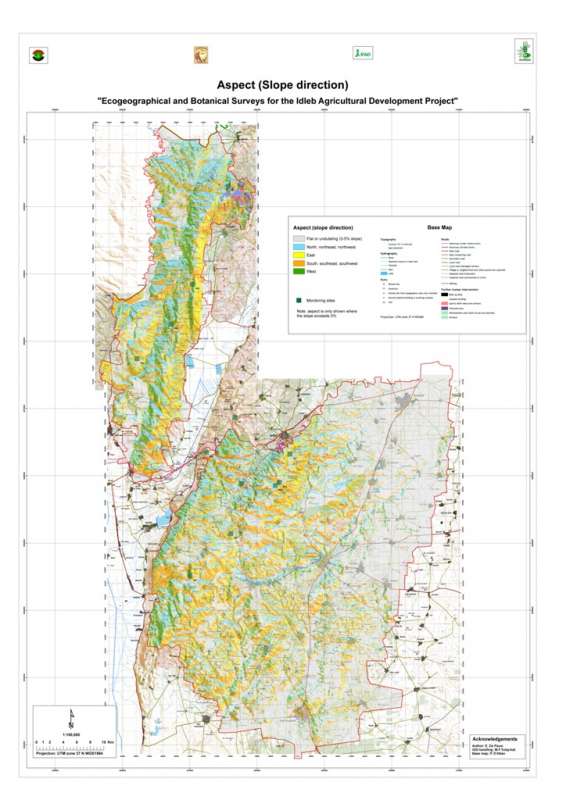
Jebel Wastani: Aspect
Characterisation of the agricultural environment in Jebel Zawia and in Jebel Wastani with a view to develop management plans for areas with valuable plant biodiversity (Idleb Rural Development Project)
Slope direction the Jebel Wastani area.
International Center for Agricultural Research in the Dry Areas (ICARDA)
2008
slope, aspect, direction
Syria, Idleb, Wastani
36.291735
36.563832
36.228515
35.744568
D_WGS_1984
WGS_1984
6378137.000000
298.257224

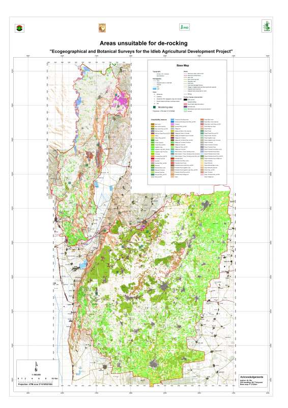
Jebel Wastani Area: Unsuitability for De-Rocking
Unsuitable zones for de-rocking farming system in Jebel Wastani area
Metadataclose[x]
Jebel Wastani Area: Unsuitability for De-Rocking
Characterisation of the agricultural environment in Jebel Zawia and in Jebel Wastani with a view to develop management plans for areas with valuable plant biodiversity (Idleb Rural Development Project)
Unsuitable zones for de-rocking farming system in Jebel Wastani area
International Center for Agricultural Research in the Dry Areas (ICARDA)
2008
de-rocking, land reclamation, rock removal
Syria, Idleb, Wastani
36.291599
36.563816
36.228634
35.744399
D_WGS_1984
WGS_1984
6378137.000000
298.257224

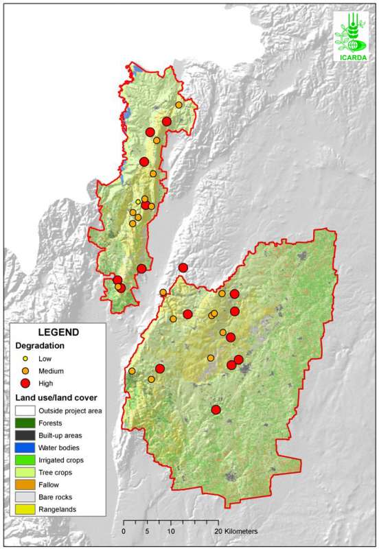
Idleb Rural Development Project Area: Vegetation Degradation
Level of vegetation degradation observed in Jebel Zawia and Jebel Wastani
Metadataclose[x]
Idleb Rural Development Project Area: Vegetation Degradation
Characterisation of the agricultural environment in Jebel Zawia and in Jebel Wastani with a view to develop management plans for areas with valuable plant biodiversity (Idleb Rural Development Project)
Level of vegetation degradation observed in Jebel Zawia and Jebel Wastani
International Center for Agricultural Research in the Dry Areas (ICARDA)
2008
vegetation, degradation
Syria, Idleb, Wastani, Zawia
36.364215
36.664777
36.148592
35.563753
D_WGS_1984
WGS_1984
6378137.000000
298.257224
Idleb Rural Development Project Area: Unsuitability for De-Rocking
Unsuitable zones for de-rocking farming system in Jebel Wastani and Jebel Zawia areas
Metadataclose[x]
Idleb Rural Development Project Area: Unsuitability for De-Rocking
Characterisation of the agricultural environment in Jebel Zawia and in Jebel Wastani with a view to develop management plans for areas with valuable plant biodiversity (Idleb Rural Development Project)
Unsuitable zones for de-rocking farming system in Jebel Wastani and Jebel Zawia areas
International Center for Agricultural Research in the Dry Areas (ICARDA)
2008
de-rocking, land reclamation, rock removal
Syria, Idleb, Wastani, Zawia
36.291599
36.900070
36.234916
35.375382
D_WGS_1984
WGS_1984
6378137.000000
298.257224

Growing Period End in Karkheh River Basin
End month of the temperature- and moisture-limited growing period in Karkheh river basin
Metadataclose[x]
Growing Period End in Karkheh River Basin
Characterization of agricultural climates of the Karkheh River Basin
End month of the temperature- and moisture-limited growing period in Karkheh river basin
International Center for Agricultural Research in the Dry Areas (ICARDA)
2008
moisture- and temperature-limited growing period, growing period end month, agricultural climates
Iran, Karkheh river basin
46.100529
49.162195
34.960947
30.953447
D_WGS_1984
WGS_1984
6378137.000000
298.257224

Metadataclose[x]
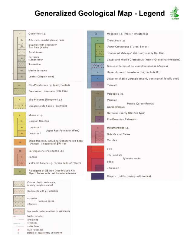
Geology of the Karkheh River Basin
Support the agro-ecosystems characterisation in the Karkheh river basin
Geology of the Karkheh river basin
International Center for Agricultural Research in the Dry Areas (ICARDA)
2008
geology
Iran, Karkheh river basin
46.099693
49.162126
34.961690
30.953412
D_WGS_1984
WGS_1984
6378137.000000
298.257224

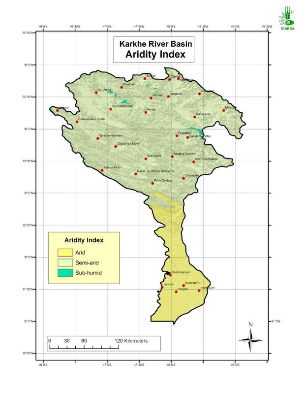
Aridity index in Karkheh river basin
Aridity Index in the Karkheh River Basin
Metadataclose[x]
Aridity index in Karkheh river basin
Determination of the moisture regime in the Karkheh river basin
Aridity Index in the Karkheh River Basin
International Center for Agricultural Research in the Dry Areas (ICARDA)
2008
aridity index, moisture regime, agroclimatic zones
Iran, Karkheh river basin
46.100529
49.162195
34.960947
30.953447
D_WGS_1984
WGS_1984
6378137.000000
298.257224