


Geoinformatics Solutions for Integrated Agro-ecosystems Research
GIS Data
Maps in: CACILM

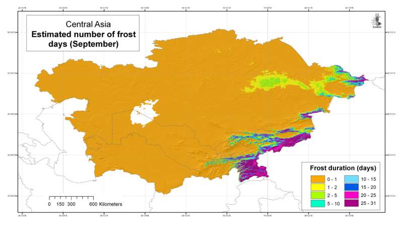
Estimated number of frost days: September
Estimated number of frost days in Central Asia at 30 arc-second ( about 1 km) resolution: September
Metadataclose[x]
Estimated number of frost days: September
Developed for geospatial applications that require location-specific climatic information in places where no nearby climatic station exists
Estimated number of frost days in Central Asia at 30 arc-second ( about 1 km) resolution: September
International Center for Agricultural Research in the Dry Areas (ICARDA)
2008
climate, temperature, frost
Central Asia, Tajikistan, Turkmenistan, Kazakhstan, Uzbekistan, Kyrgyzstan
46.491856
87.308524
55.424429
35.141094
D_WGS_1984
WGS_1984
6378137.000000
298.257224

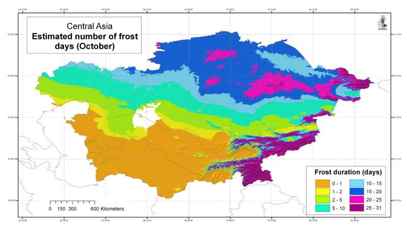
Estimated number of frost days: October
Estimated number of frost days in Central Asia at 30 arc-second ( about 1 km) resolution: October
Metadataclose[x]
Estimated number of frost days: October
Developed for geospatial applications that require location-specific climatic information in places where no nearby climatic station exists
Estimated number of frost days in Central Asia at 30 arc-second ( about 1 km) resolution: October
International Center for Agricultural Research in the Dry Areas (ICARDA)
2008
climate, temperature, frost
Central Asia, Tajikistan, Turkmenistan, Kazakhstan, Uzbekistan, Kyrgyzstan
46.491856
87.308524
55.424429
35.141094
D_WGS_1984
WGS_1984
6378137.000000
298.257224

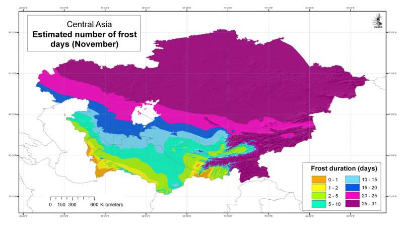
Estimated number of frost days: November
Estimated number of frost days in Central Asia at 30 arc-second ( about 1 km) resolution: November
Metadataclose[x]
Estimated number of frost days: November
Developed for geospatial applications that require location-specific climatic information in places where no nearby climatic station exists
Estimated number of frost days in Central Asia at 30 arc-second ( about 1 km) resolution: November
International Center for Agricultural Research in the Dry Areas (ICARDA)
2008
climate, temperature, frost
Central Asia, Tajikistan, Turkmenistan, Kazakhstan, Uzbekistan, Kyrgyzstan
46.491856
87.308524
55.424429
35.141094
D_WGS_1984
WGS_1984
6378137.000000
298.257224

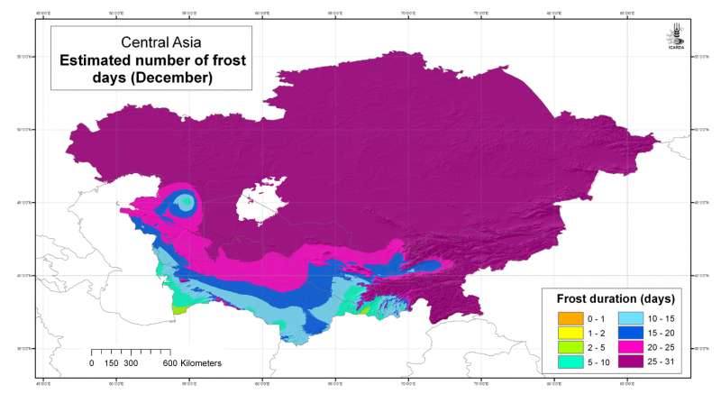
Estimated number of frost days: December
Estimated number of frost days in Central Asia at 30 arc-second ( about 1 km) resolution: December
Metadataclose[x]
Estimated number of frost days: December
Developed for geospatial applications that require location-specific climatic information in places where no nearby climatic station exists
Estimated number of frost days in Central Asia at 30 arc-second ( about 1 km) resolution: December
International Center for Agricultural Research in the Dry Areas (ICARDA)
2008
climate, temperature, frost
Central Asia, Tajikistan, Turkmenistan, Kazakhstan, Uzbekistan, Kyrgyzstan
46.491856
87.308524
55.424429
35.141094
D_WGS_1984
WGS_1984
6378137.000000
298.257224

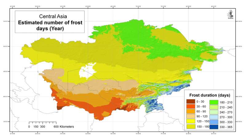
Estimated number of frost days: Year
Estimated number of frost days in Central Asia at 30 arc-second ( about 1 km) resolution: Year
Metadataclose[x]
Estimated number of frost days: Year
Developed for geospatial applications that require location-specific climatic information in places where no nearby climatic station exists
Estimated number of frost days in Central Asia at 30 arc-second ( about 1 km) resolution: Year
International Center for Agricultural Research in the Dry Areas (ICARDA)
2008
climate, temperature, frost
Central Asia, Tajikistan, Turkmenistan, Kazakhstan, Uzbekistan, Kyrgyzstan
46.491856
87.308524
55.424429
35.141094
D_WGS_1984
WGS_1984
6378137.000000
298.257224

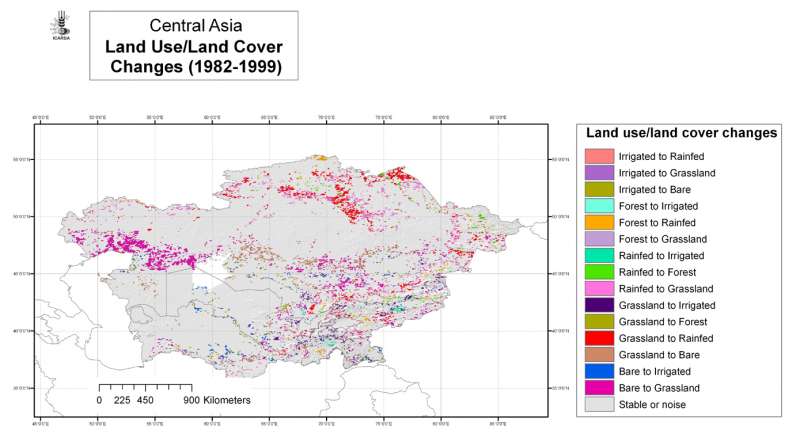
Central Asia: land use/land cover changes 1982-1999
Land use/land cover change classes for Central Asia at 4 arc-minute ( about 8 km) resolution
Metadataclose[x]
Central Asia: land use/land cover changes 1982-1999
To map areas of land use/land cover change and stability in the period 1982-1999
Land use/land cover change classes for Central Asia at 4 arc-minute ( about 8 km) resolution
International Center for Agricultural Research in the Dry Areas (ICARDA)
2008
land use, land cover, AVHRR, remote sensing, land degradation
Central Asia, Tajikistan, Turkmenistan, Kazakhstan, Uzbekistan, Kyrgyzstan
46.491856
87.292060
55.407862
35.141094
D_WGS_1984
WGS_1984
6378137.000000
298.257224
")
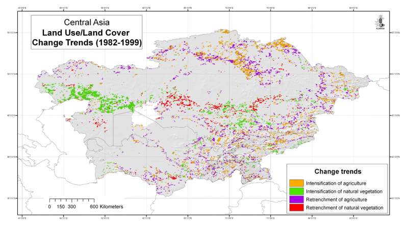
Central Asia: land use/land cover change trends (1982-1999)
Land use/land cover change trends for Central Asia at 4 arc-minute ( about 8 km) resolution
Metadataclose[x]
Central Asia: land use/land cover change trends (1982-1999)
To map areas of land use/land cover change and stability in the period 1982-1999
Land use/land cover change trends for Central Asia at 4 arc-minute ( about 8 km) resolution
International Center for Agricultural Research in the Dry Areas (ICARDA)
2008
land use change, land cover change, AVHRR, remote sensing, land degradation
Central Asia, Tajikistan, Turkmenistan, Kazakhstan, Uzbekistan, Kyrgyzstan
46.491856
87.292060
55.407862
35.141094
D_WGS_1984
WGS_1984
6378137.000000
298.257224

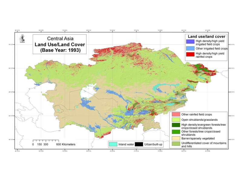
Central Asia: land use/land cover base year 1993
Land use/land cover classes for Central Asia at 30 arc-second ( about 1 km) resolution, base year 1993
Metadataclose[x]
Central Asia: land use/land cover base year 1993
To map land use/land cover using a simple but reliable classification system
Land use/land cover classes for Central Asia at 30 arc-second ( about 1 km) resolution, base year 1993
International Center for Agricultural Research in the Dry Areas (ICARDA)
2008
land use, land cover, AVHRR, remote sensing
Central Asia, Tajikistan, Turkmenistan, Kazakhstan, Uzbekistan, Kyrgyzstan
46.491856
87.308524
55.424429
35.141094
D_WGS_1984
WGS_1984
6378137.000000
298.257224

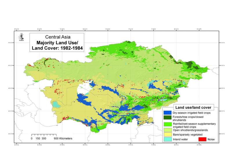
Central Asia: Majority land use/land cover during the period 1982-84
Majority land use/land cover in Central Asia during the period 1982-84 at 4 arc-minute ( about 8 km) resolution.
Metadataclose[x]
Central Asia: Majority land use/land cover during the period 1982-84
To map areas of land use/land cover change and stability in the period 1982-1999
Majority land use/land cover in Central Asia during the period 1982-84 at 4 arc-minute ( about 8 km) resolution.
International Center for Agricultural Research in the Dry Areas (ICARDA)
2008
land use, land cover, AVHRR, remote sensing, land degradation
Central Asia, Tajikistan, Turkmenistan, Kazakhstan, Uzbekistan, Kyrgyzstan
46.491856
87.292060
55.407862
35.141094
D_WGS_1984
WGS_1984
6378137.000000
298.257224

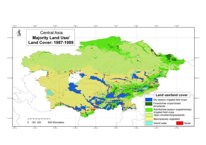
Central Asia: Majority land use/land cover during the period 1987-89
Majority land use/land cover in Central Asia during the period 1987-89 at 4 arc-minute ( about 8 km) resolution.
Metadataclose[x]
Central Asia: Majority land use/land cover during the period 1987-89
To map areas of land use/land cover change and stability in the period 1982-1999
Majority land use/land cover in Central Asia during the period 1987-89 at 4 arc-minute ( about 8 km) resolution.
International Center for Agricultural Research in the Dry Areas (ICARDA)
2008
land use, land cover, AVHRR, remote sensing, land degradation
Central Asia, Tajikistan, Turkmenistan, Kazakhstan, Uzbekistan, Kyrgyzstan
46.491856
87.292060
55.407862
35.141094
D_WGS_1984
WGS_1984
6378137.000000
298.257224