


Geoinformatics Solutions for Integrated Agro-ecosystems Research
GIS Data
Maps in: Climate

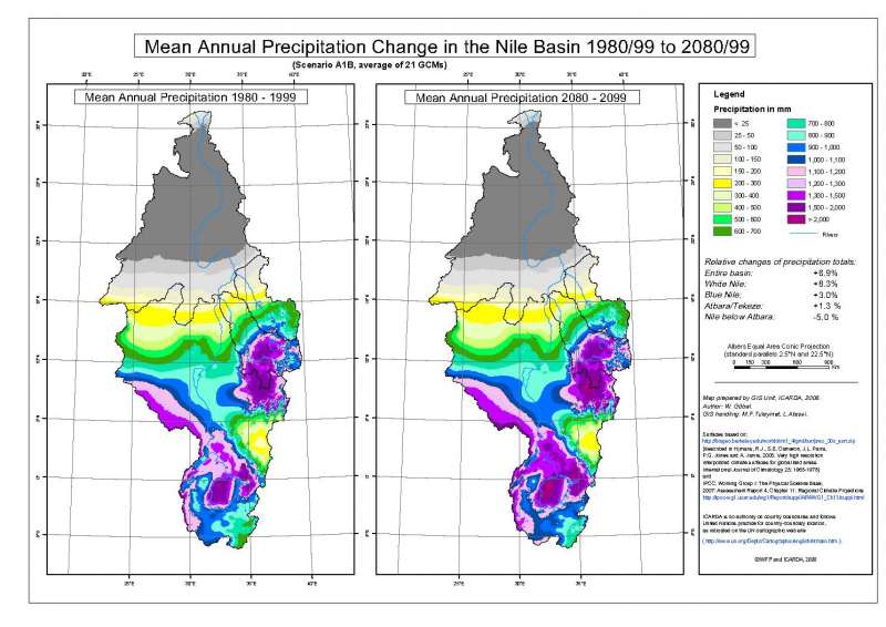
Nile Basin: Annual Precipitation 1980-1999
Mean annual precipitation 1980-1999 in the entire Nile drainage basin.
Metadataclose[x]
Nile Basin: Annual Precipitation 1980-1999
WFP Workshop on "Climate Change and Food Security", Cairo, Egypt, 3-4 November 2008
Mean annual precipitation 1980-1999 in the entire Nile drainage basin.
International Center for Agricultural Research in the Dry Areas (ICARDA)
2008
Future climate, temperature
CWANA, Egypt, Nile basin
21.294803
40.663201
31.590093
-6.201949
D_WGS_1984
WGS_1984
6378137.000000
298.257224
Blue Nile Basin: Annual Precipitation 1980-1999
Mean annual precipitation 1980-1999 in the Blue Nile drainage basin.
Metadataclose[x]
Blue Nile Basin: Annual Precipitation 1980-1999
WFP Workshop on "Climate Change and Food Security", Cairo, Egypt, 3-4 November 2008
Mean annual precipitation 1980-1999 in the Blue Nile drainage basin.
International Center for Agricultural Research in the Dry Areas (ICARDA)
2008
Future climate, temperature
CWANA, Egypt, Nile basin
32.406404
40.021245
16.013213
7.158201
D_WGS_1984
WGS_1984
6378137.000000
298.257224
Atbara/Tekeze Basin: Annual Temperature 1980-1999
Mean annual precipitation 1980-1999 in the Atbara/Tekeze drainage basin.
Metadataclose[x]
Atbara/Tekeze Basin: Annual Temperature 1980-1999
WFP Workshop on "Climate Change and Food Security", Cairo, Egypt, 3-4 November 2008
Mean annual precipitation 1980-1999 in the Atbara/Tekeze drainage basin.
International Center for Agricultural Research in the Dry Areas (ICARDA)
2008
Future climate, temperature
CWANA, Egypt, Nile basin
33.839945
39.996773
19.127797
11.636838
D_WGS_1984
WGS_1984
6378137.000000
298.257224
Nile Basin: Annual Precipitation 2080-2099
Mean annual precipitation 2080-2099 in the entire Nile drainage basin.
Metadataclose[x]
Nile Basin: Annual Precipitation 2080-2099
WFP Workshop on "Climate Change and Food Security", Cairo, Egypt, 3-4 November 2008
Mean annual precipitation 2080-2099 in the entire Nile drainage basin.
International Center for Agricultural Research in the Dry Areas (ICARDA)
2008
Future climate, temperature
CWANA, Egypt, Nile basin
21.294803
40.663201
31.590093
-6.201949
D_WGS_1984
WGS_1984
6378137.000000
298.257224
White Nile Basin: Annual Precipitation 2080-2099
Mean annual precipitation 2080-2099 in the White Nile drainage basin.
Metadataclose[x]
White Nile Basin: Annual Precipitation 2080-2099
WFP Workshop on "Climate Change and Food Security", Cairo, Egypt, 3-4 November 2008
Mean annual precipitation 2080-2099 in the White Nile drainage basin.
International Center for Agricultural Research in the Dry Areas (ICARDA)
2008
Future climate, temperature
CWANA, Egypt, Nile basin
23.245776
38.970423
16.698629
-6.167352
D_WGS_1984
WGS_1984
6378137.000000
298.257224

Agroclimatic Zones in CWANA and Eurasia
Agroclimatic Zones in the Central and West Asia - North Africa and Eurasia regions
Metadataclose[x]
Agroclimatic Zones in CWANA and Eurasia
Building a new eco-climatic database was established consisting of GIS layers of soil and climatic parameters at 1 km resolution, covering the entire CWANA and Eurasia region.
Agroclimatic Zones in the Central and West Asia - North Africa and Eurasia regions
International Center for Agricultural Research in the Dry Areas (ICARDA)
2008
climate, agroclimatic zones
CWANA, Eurasia
45.602975
48.672963
39.698607
37.231951
D_WGS_1984
WGS_1984
6378137.000000
298.257224

Aridity in CWANA and Eurasia
Aridity Index in the Central and West Asia - North Africa and Eurasia regions
Metadataclose[x]
Aridity in CWANA and Eurasia
Building a new eco-climatic database was established consisting of GIS layers of soil and climatic parameters at 1 km resolution, covering the entire CWANA and Eurasia region.
Aridity Index in the Central and West Asia - North Africa and Eurasia regions
International Center for Agricultural Research in the Dry Areas (ICARDA)
2008
climate, aridity index
CWANA, Eurasia
45.602975
48.672963
39.698607
37.231951
D_WGS_1984
WGS_1984
6378137.000000
298.257224

Potential Evapotranspiration in CWANA and Eurasia
Potential evapotranspiration in the Central and West Asia - North Africa and Eurasia regions
Metadataclose[x]
Potential Evapotranspiration in CWANA and Eurasia
Building a new eco-climatic database was established consisting of GIS layers of soil and climatic parameters at 1 km resolution, covering the entire CWANA and Eurasia region.
Potential evapotranspiration in the Central and West Asia - North Africa and Eurasia regions
International Center for Agricultural Research in the Dry Areas (ICARDA)
2008
climate, potential evapotranspiration, Penman-Monteith, Hargreaves
CWANA, Eurasia
-0.000181
0.001907
0.000728
-0.000016
D_WGS_1984
WGS_1984
6378137.000000
298.257224

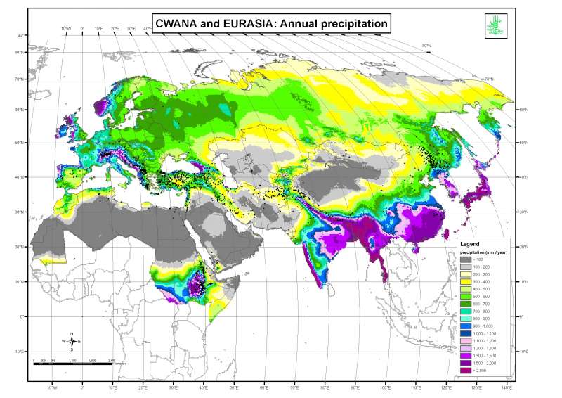
Precipitation in CWANA and Eurasia
Annual rainfall in the Central and West Asia - North Africa and Eurasia regions
Metadataclose[x]
Precipitation in CWANA and Eurasia
Building a new eco-climatic database was established consisting of GIS layers of soil and climatic parameters at 1 km resolution, covering the entire CWANA and Eurasia region.
Annual rainfall in the Central and West Asia - North Africa and Eurasia regions
International Center for Agricultural Research in the Dry Areas (ICARDA)
2008
climate, annual precipitation
CWANA, Eurasia
45.602975
48.672963
39.698607
37.231951
D_WGS_1984
WGS_1984
6378137.000000
298.257224

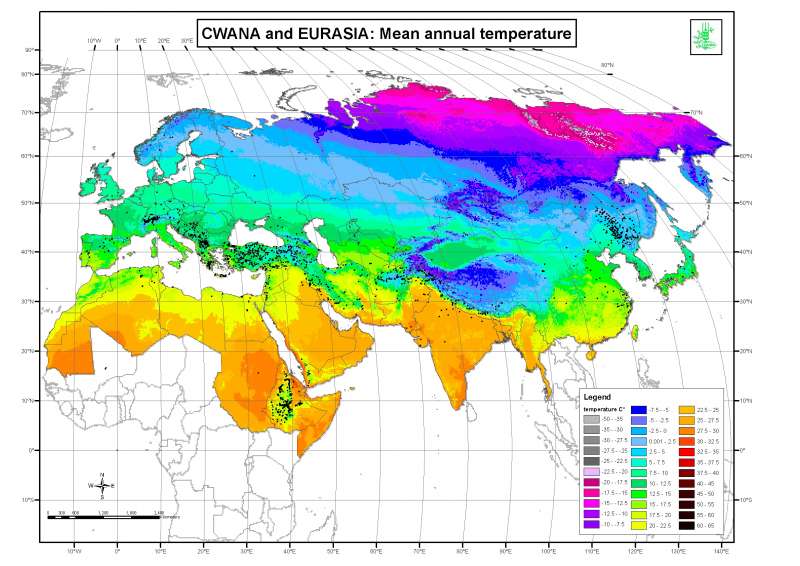
Average Temperature in CWANA and Eurasia
Annual mean temperature in the Central and West Asia - North Africa and Eurasia regions
Metadataclose[x]
Average Temperature in CWANA and Eurasia
Building a new eco-climatic database was established consisting of GIS layers of soil and climatic parameters at 1 km resolution, covering the entire CWANA and Eurasia region.
Annual mean temperature in the Central and West Asia - North Africa and Eurasia regions
International Center for Agricultural Research in the Dry Areas (ICARDA)
2008
climate, average temperature
CWANA, Eurasia
-17.103181
180.005152
77.734305
-1.657362
D_WGS_1984
WGS_1984
6378137.000000
298.257224