


Geoinformatics Solutions for Integrated Agro-ecosystems Research
GIS Data
Maps in: Suitability

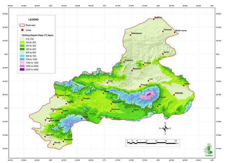
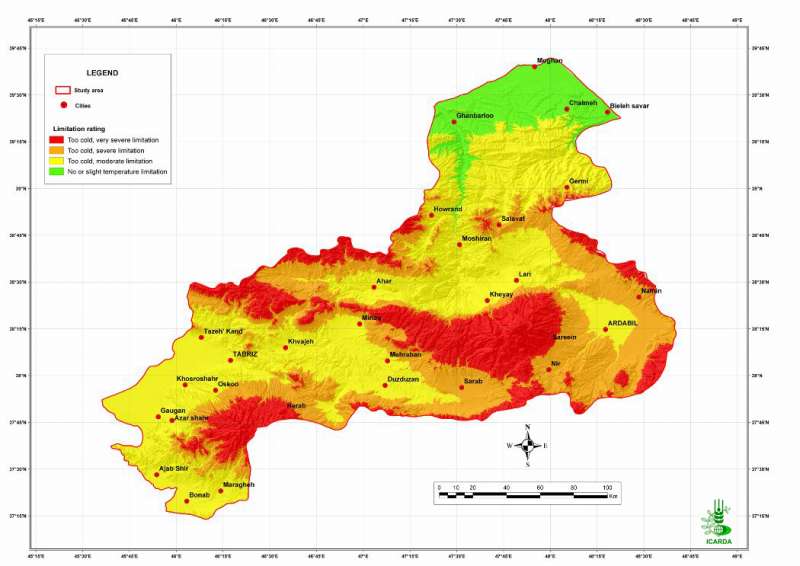
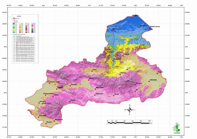
Pilot Area in NW Iran: Annual Chilling Degree Days
Annual chilling degree days in the Aras and the Daryacheh-Uromieh basins, North-West Iran (days below 0�������°C)
Metadataclose[x]
Pilot Area in NW Iran: Annual Chilling Degree Days
Characterization of the agro-ecological conditions in the pilot area of Aras and Daryacheh-Uromieh basins (North-West Iran), with the view to determine the land suitability for a range of crop groups in the area
Annual chilling degree days in the Aras and the Daryacheh-Uromieh basins, North-West Iran (days below 0�������°C)
International Center for Agricultural Research in the Dry Areas (ICARDA)
2008
agro-ecosystems, climate, chilling degree days
Iran, pilot area, Aras, Daryacheh-Uromieh
46.100529
49.162195
34.960947
30.953447
D_WGS_1984
WGS_1984
6378137.000000
298.257224

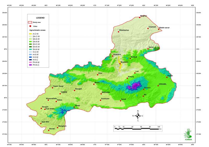
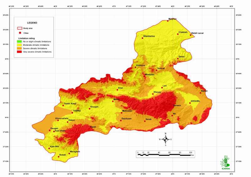
Pilot Area in NW Iran: Agroclimatic Zones
Agroclimatic zones in the Aras and the Daryacheh-Uromieh basins, North-West Iran
Metadataclose[x]
Pilot Area in NW Iran: Agroclimatic Zones
Characterization of the agro-ecological conditions in the pilot area of Aras and Daryacheh-Uromieh basins (North-West Iran), with the view to determine the land suitability for a range of crop groups in the area
Agroclimatic zones in the Aras and the Daryacheh-Uromieh basins, North-West Iran
International Center for Agricultural Research in the Dry Areas (ICARDA)
2008
agro-ecosystems, climate, agroclimatic zones
Iran, pilot area, Aras, Daryacheh-Uromieh
46.100529
49.162195
34.960947
30.953447
D_WGS_1984
WGS_1984
6378137.000000
298.257224

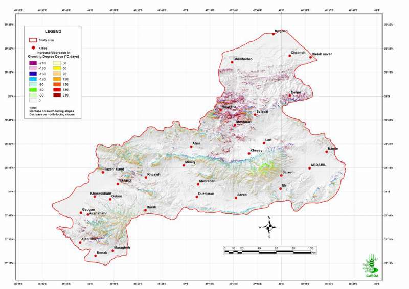
Pilot Area in NW Iran: Aspect Adjusted Growing Degree Days
Variation in Growing degree days due to slope direction in the Aras and the Daryacheh-Uromieh basins, North-West Iran
Metadataclose[x]
Pilot Area in NW Iran: Aspect Adjusted Growing Degree Days
Characterization of the agro-ecological conditions in the pilot area of Aras and Daryacheh-Uromieh basins (North-West Iran), with the view to determine the land suitability for a range of crop groups in the area
Variation in Growing degree days due to slope direction in the Aras and the Daryacheh-Uromieh basins, North-West Iran
International Center for Agricultural Research in the Dry Areas (ICARDA)
2008
agro-ecosystems, climate, degree days
Iran, pilot area, Aras, Daryacheh-Uromieh
46.100529
49.162195
34.960947
30.953447
D_WGS_1984
WGS_1984
6378137.000000
298.257224

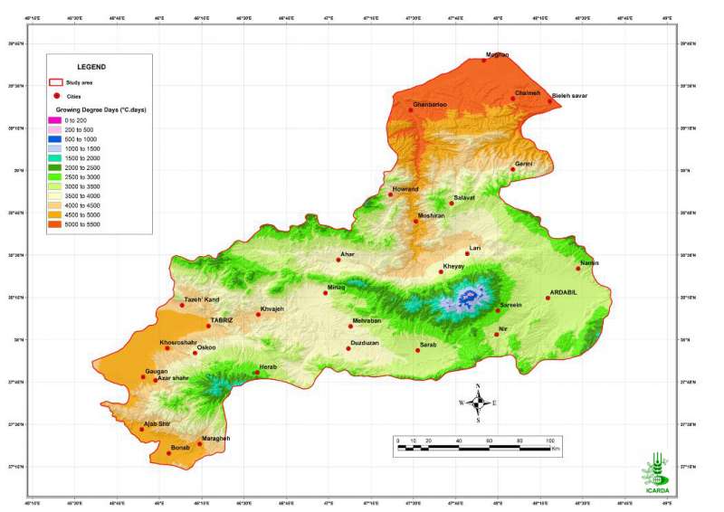
Pilot Area in NW Iran: Growing Degree Days
Annual growing degree days in the Aras and the Daryacheh-Uromieh basins, North-West Iran
Metadataclose[x]
Pilot Area in NW Iran: Growing Degree Days
Characterization of the agro-ecological conditions in the pilot area of Aras and Daryacheh-Uromieh basins (North-West Iran), with the view to determine the land suitability for a range of crop groups in the area
Annual growing degree days in the Aras and the Daryacheh-Uromieh basins, North-West Iran
International Center for Agricultural Research in the Dry Areas (ICARDA)
2008
agro-ecosystems, climate, degree days
Iran, pilot area, Aras, Daryacheh-Uromieh
46.100529
49.162195
34.960947
30.953447
D_WGS_1984
WGS_1984
6378137.000000
298.257224
Pilot Area in NW Iran: Aridity Index
Aridity index in the Aras and the Daryacheh-Uromieh basins, North-West Iran (ratio of precipitation over reference evapotranspiration)
Metadataclose[x]
Pilot Area in NW Iran: Aridity Index
Characterization of the agro-ecological conditions in the pilot area of Aras and Daryacheh-Uromieh basins (North-West Iran), with the view to determine the land suitability for a range of crop groups in the area
Aridity index in the Aras and the Daryacheh-Uromieh basins, North-West Iran (ratio of precipitation over reference evapotranspiration)
International Center for Agricultural Research in the Dry Areas (ICARDA)
2008
agro-ecosystems, climate, aridity index
Iran, pilot area, Aras, Daryacheh-Uromieh
46.100529
49.162195
34.960947
30.953447
D_WGS_1984
WGS_1984
6378137.000000
298.257224

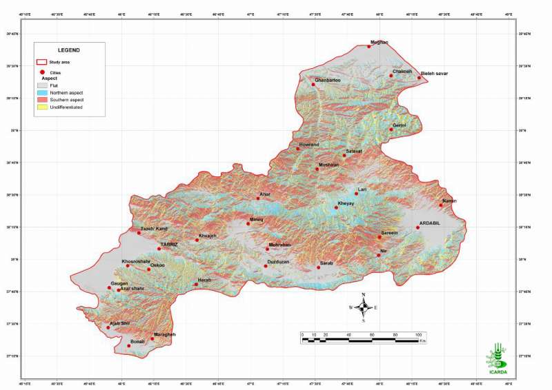
Pilot Area in NW Iran: Slope Aspect
Slope direction in the Aras and the Daryacheh-Uromieh basins, North-West Iran
Metadataclose[x]
Pilot Area in NW Iran: Slope Aspect
Characterization of the agro-ecological conditions in the pilot area of Aras and Daryacheh-Uromieh basins (North-West Iran), with the view to determine the land suitability for a range of crop groups in the area
Slope direction in the Aras and the Daryacheh-Uromieh basins, North-West Iran
International Center for Agricultural Research in the Dry Areas (ICARDA)
2008
agro-ecosystems, slope, aspect
Iran, pilot area, Aras and Daryacheh-Uromieh basins
46.100529
49.162195
34.960947
30.953447
D_WGS_1984
WGS_1984
6378137.000000
298.257224

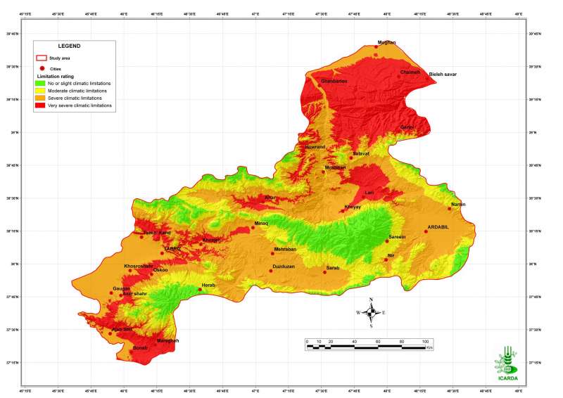
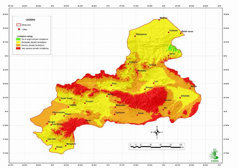
Pilot Area in NW Iran: Adequacy of Temperature for Barley
Suitability of temperature for barley crops in the Aras and the Daryacheh-Uromieh basins, North-West Iran. The suitability is determined by crop-specific thresholds defined on a degree.days scale.
Metadataclose[x]
Pilot Area in NW Iran: Adequacy of Temperature for Barley
Determine the climate and the land suitability for barley crops in the study area
Suitability of temperature for barley crops in the Aras and the Daryacheh-Uromieh basins, North-West Iran. The suitability is determined by crop-specific thresholds defined on a degree.days scale.
International Center for Agricultural Research in the Dry Areas (ICARDA)
2008
suitability, climate, temperature, barley
Iran, pilot area, Aras and Daryacheh-Uromieh basins
46.100529
49.162195
34.960947
30.953447
D_WGS_1984
WGS_1984
6378137.000000
298.257224

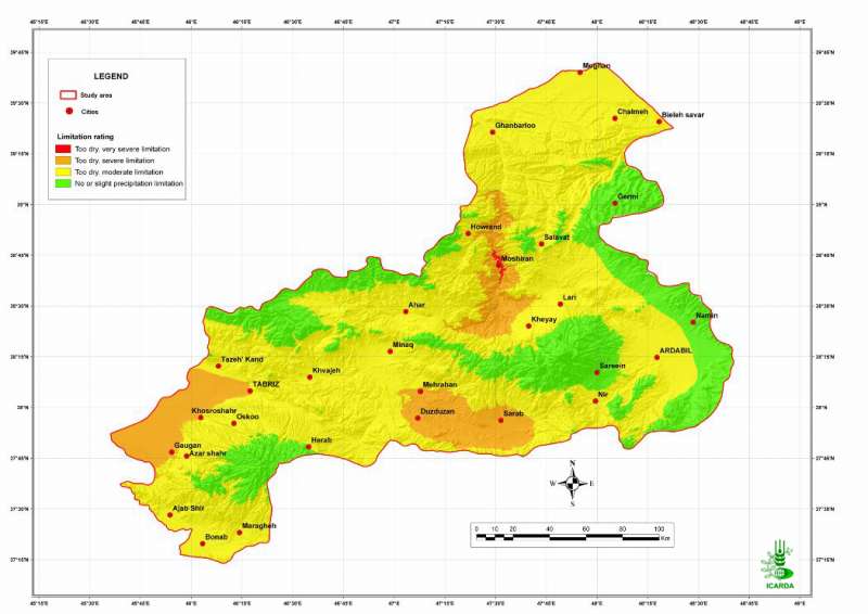
Pilot Area in NW Iran: Adequacy of Climate for Barley
Suitability of climate conditions (temperature and precipitation) for barley crops in the Aras and the Daryacheh-Uromieh basins, North-West Iran
Metadataclose[x]
Pilot Area in NW Iran: Adequacy of Climate for Barley
Determine the land suitability for barley crops in the study area
Suitability of climate conditions (temperature and precipitation) for barley crops in the Aras and the Daryacheh-Uromieh basins, North-West Iran
International Center for Agricultural Research in the Dry Areas (ICARDA)
2008
suitability, climate, temperature, precipitation, barley
Iran, pilot area, Aras and Daryacheh-Uromieh basins
46.100529
49.162195
34.960947
30.953447
D_WGS_1984
WGS_1984
6378137.000000
298.257224

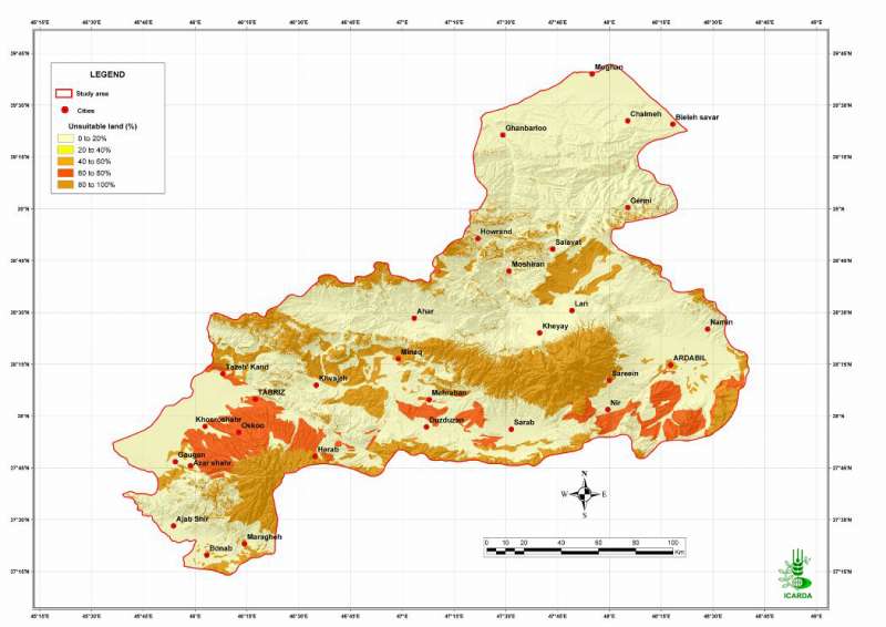
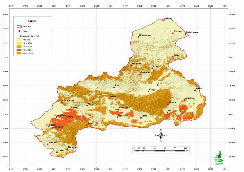
Pilot Area in NW Iran: Unsuitable Land for Barley
Percentage of unsuitable land (all factors combined) for barley crops in the Aras and the Daryacheh-Uromieh basins, North-West Iran. The factors, climate, soils and topography, are integrated by the method of the most limiting factor.
Metadataclose[x]
Pilot Area in NW Iran: Unsuitable Land for Barley
Determine the land suitability for barley crops in the study area
Percentage of unsuitable land (all factors combined) for barley crops in the Aras and the Daryacheh-Uromieh basins, North-West Iran. The factors, climate, soils and topography, are integrated by the method of the most limiting factor.
International Center for Agricultural Research in the Dry Areas (ICARDA)
2008
suitability, climate, topography, soil, unsuitable land, barley
Iran, pilot area, Aras and Daryacheh-Uromieh basins
46.100529
49.162195
34.960947
30.953447
D_WGS_1984
WGS_1984
6378137.000000
298.257224

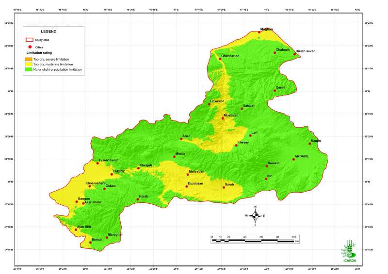
Pilot Area in NW Iran: Adequacy of Precipitation for Barley
Suitability of precipitation for barley crops in the Aras and the Daryacheh-Uromieh basins, North-West Iran
Metadataclose[x]
Pilot Area in NW Iran: Adequacy of Precipitation for Barley
Determine the climate and the land suitability for barley crops in the study area
Suitability of precipitation for barley crops in the Aras and the Daryacheh-Uromieh basins, North-West Iran
International Center for Agricultural Research in the Dry Areas (ICARDA)
2008
suitability, climate, precipitation, barley
Iran, pilot area, Aras and Daryacheh-Uromieh basins
46.100529
49.162195
34.960947
30.953447
D_WGS_1984
WGS_1984
6378137.000000
298.257224

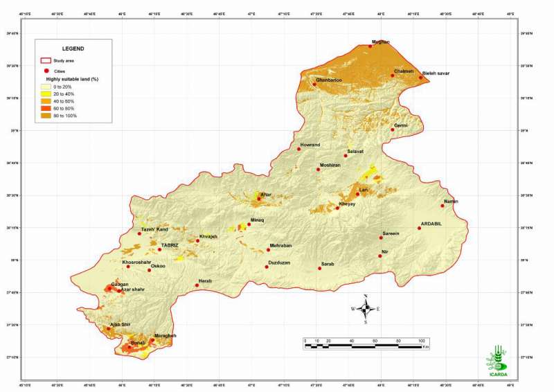
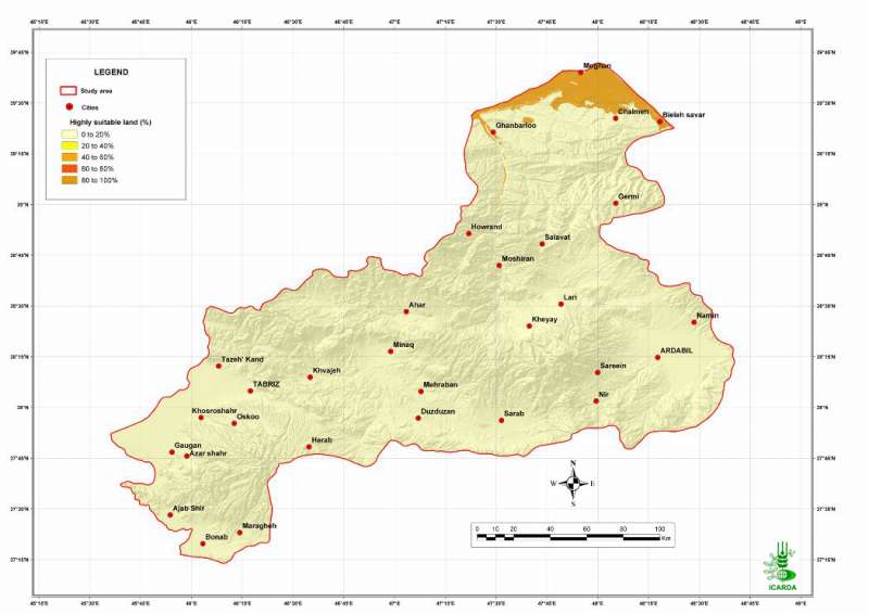
Pilot Area in NW Iran: Highly Suitable Land for Barley
Percentage of highly suitable land (all factors combined) for barley crops in the Aras and the Daryacheh-Uromieh basins, North-West Iran. The factors, climate, soils and topography, are integrated by the method of the most limiting factor.
Metadataclose[x]
Pilot Area in NW Iran: Highly Suitable Land for Barley
Determine the land suitability for barley crops in the study area
Percentage of highly suitable land (all factors combined) for barley crops in the Aras and the Daryacheh-Uromieh basins, North-West Iran. The factors, climate, soils and topography, are integrated by the method of the most limiting factor.
International Center for Agricultural Research in the Dry Areas (ICARDA)
2008
suitability, climate, topography, soil, barley
Iran, pilot area, Aras and Daryacheh-Uromieh basins
46.100529
49.162195
34.960947
30.953447
D_WGS_1984
WGS_1984
6378137.000000
298.257224

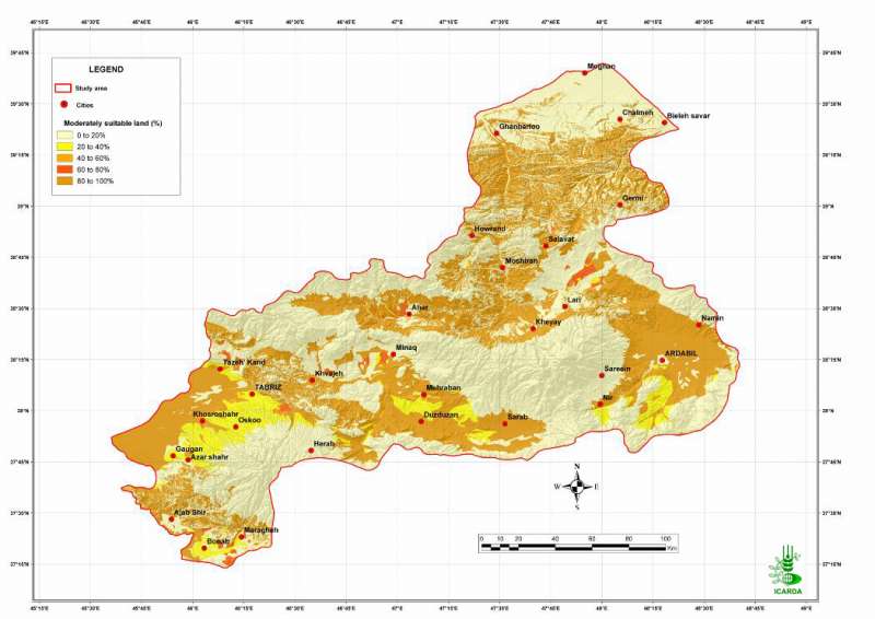
Pilot Area in NW Iran: Moderately Suitable Land for Barley
Percentage of moderately suitable land (all factors combined) for barley crops in the Aras and the Daryacheh-Uromieh basins, North-West Iran. The factors, climate, soils and topography, are integrated by the method of the most limiting factor.
Metadataclose[x]
Pilot Area in NW Iran: Moderately Suitable Land for Barley
Determine the land suitability for barley crops in the study area
Percentage of moderately suitable land (all factors combined) for barley crops in the Aras and the Daryacheh-Uromieh basins, North-West Iran. The factors, climate, soils and topography, are integrated by the method of the most limiting factor.
International Center for Agricultural Research in the Dry Areas (ICARDA)
2008
suitability, climate, topography, soil, barley
Iran, pilot area, Aras and Daryacheh-Uromieh basins
46.100529
49.162195
34.960947
30.953447
D_WGS_1984
WGS_1984
6378137.000000
298.257224

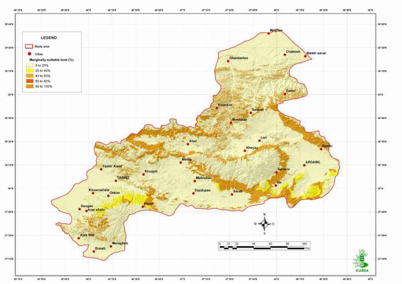
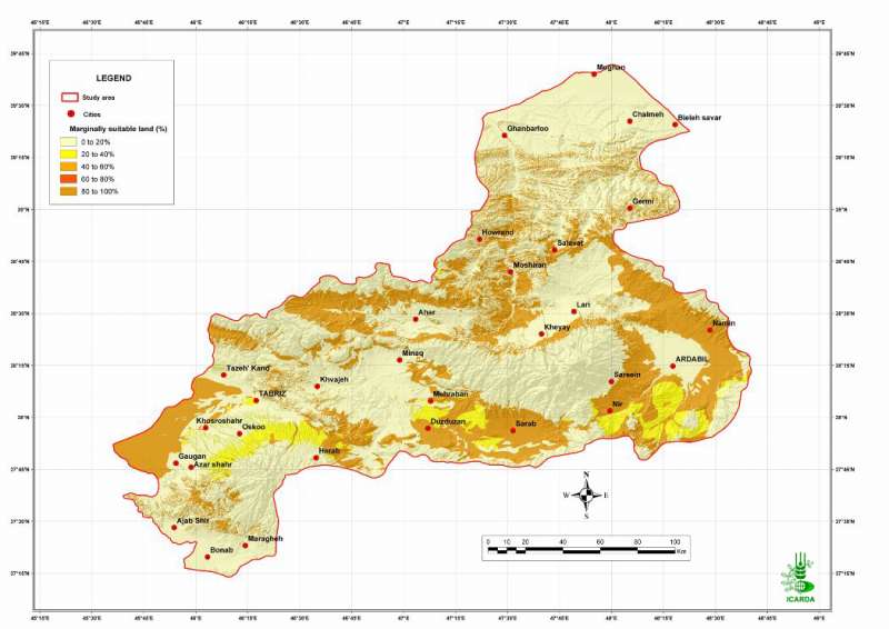
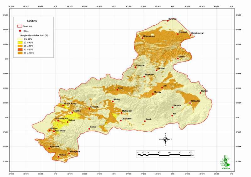
Pilot Area in NW Iran: Marginally Suitable Land for Barley
Percentage of marginally suitable land (all factors combined) for barley crops in the Aras and the Daryacheh-Uromieh basins, North-West Iran. The factors, climate, soils and topography, are integrated by the method of the most limiting factor.
Metadataclose[x]
Pilot Area in NW Iran: Marginally Suitable Land for Barley
Determine the land suitability for barley crops in the study area
Percentage of marginally suitable land (all factors combined) for barley crops in the Aras and the Daryacheh-Uromieh basins, North-West Iran. The factors, climate, soils and topography, are integrated by the method of the most limiting factor.
International Center for Agricultural Research in the Dry Areas (ICARDA)
2008
suitability, climate, topography, soil, barley
Iran, pilot area, Aras and Daryacheh-Uromieh basins
46.100529
49.162195
34.960947
30.953447
D_WGS_1984
WGS_1984
6378137.000000
298.257224

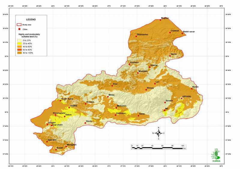
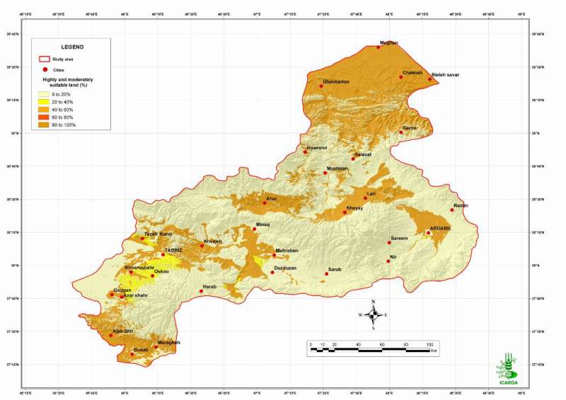
Pilot Area in NW Iran: Suitable Land for Barley
Percentage of highly and moderately suitable land (all factors combined) for barley crops in the Aras and the Daryacheh-Uromieh basins, North-West Iran. The factors, climate, soils and topography, are integrated by the method of the most limiting factor.
Metadataclose[x]
Pilot Area in NW Iran: Suitable Land for Barley
Determine the land suitability for barley crops in the study area
Percentage of highly and moderately suitable land (all factors combined) for barley crops in the Aras and the Daryacheh-Uromieh basins, North-West Iran. The factors, climate, soils and topography, are integrated by the method of the most limiting factor.
International Center for Agricultural Research in the Dry Areas (ICARDA)
2008
suitability, climate, topography, soil, suitable land, barley
Iran, pilot area, Aras and Daryacheh-Uromieh basins
46.100529
49.162195
34.960947
30.953447
D_WGS_1984
WGS_1984
6378137.000000
298.257224

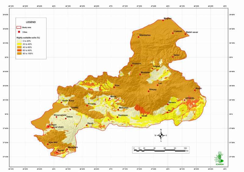
Pilot Area in NW Iran: Highly Suitable Soils for Crops
Percentage of highly suitable soils for crops in the Aras and the Daryacheh-Uromieh basins, North-West Iran. The same ratings were used for the all range of crops (barley, wheat, chickpea, olive, lentil, potato/sugarbeet, and safflower).
Metadataclose[x]
Pilot Area in NW Iran: Highly Suitable Soils for Crops
Determine the land suitability for crops in the study area
Percentage of highly suitable soils for crops in the Aras and the Daryacheh-Uromieh basins, North-West Iran. The same ratings were used for the all range of crops (barley, wheat, chickpea, olive, lentil, potato/sugarbeet, and safflower).
International Center for Agricultural Research in the Dry Areas (ICARDA)
2008
suitability, soil, barley, wheat, chickpea, lentil, olive, safflower, sugarbeet, potato
Iran, pilot area, Aras and Daryacheh-Uromieh basins
46.100529
49.162195
34.960947
30.953447
D_WGS_1984
WGS_1984
6378137.000000
298.257224

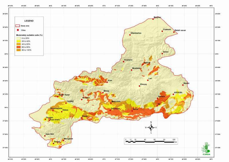
Pilot Area in NW Iran: Moderately Suitable Soils for Crops
Percentage of moderately suitable soils for barley crops in the Aras and the Daryacheh-Uromieh basins, North-West Iran. The same ratings were used for the all range of crops (barley, wheat, chickpea, olive, lentil, potato/sugarbeet, and safflower).
Metadataclose[x]
Pilot Area in NW Iran: Moderately Suitable Soils for Crops
Determine the land suitability for barley crops in the study area
Percentage of moderately suitable soils for barley crops in the Aras and the Daryacheh-Uromieh basins, North-West Iran. The same ratings were used for the all range of crops (barley, wheat, chickpea, olive, lentil, potato/sugarbeet, and safflower).
International Center for Agricultural Research in the Dry Areas (ICARDA)
2008
suitability, soil, barley, wheat, chickpea, lentil, safflower, sugarbeet, olive, potato
Iran, pilot area, Aras and Daryacheh-Uromieh basins
46.100529
49.162195
34.960947
30.953447
D_WGS_1984
WGS_1984
6378137.000000
298.257224

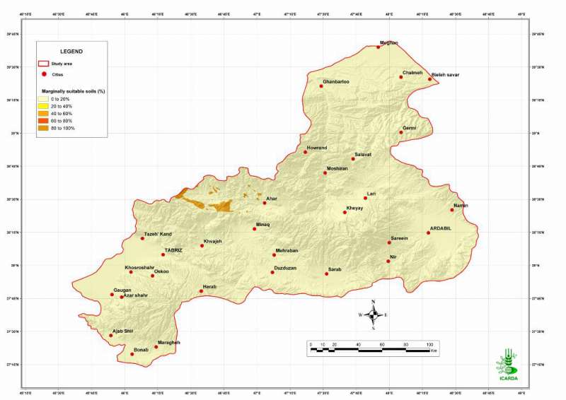
Pilot Area in NW Iran: Marginally Suitable Soils for Crops
Percentage of marginally suitable soils for barley crops in the Aras and the Daryacheh-Uromieh basins, North-West Iran. The same ratings were used for the all range of crops (barley, wheat, chickpea, olive, lentil, potato/sugarbeet, and safflower).
Metadataclose[x]
Pilot Area in NW Iran: Marginally Suitable Soils for Crops
Determine the land suitability for barley crops in the study area
Percentage of marginally suitable soils for barley crops in the Aras and the Daryacheh-Uromieh basins, North-West Iran. The same ratings were used for the all range of crops (barley, wheat, chickpea, olive, lentil, potato/sugarbeet, and safflower).
International Center for Agricultural Research in the Dry Areas (ICARDA)
2008
suitability, soil, barley, wheat, lentil, olive, chickpea, sugarbeet, safflower, potato
Iran, pilot area, Aras and Daryacheh-Uromieh basins
46.100529
49.162195
34.960947
30.953447
D_WGS_1984
WGS_1984
6378137.000000
298.257224

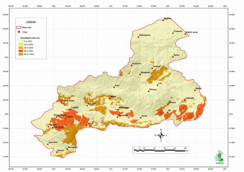
Pilot Area in NW Iran: Unsuitable Soils for Crops
Percentage of unsuitable soils for crops in the Aras and the Daryacheh-Uromieh basins, North-West Iran. The same ratings were used for the all range of crops (barley, wheat, chickpea, olive, lentil, potato/sugarbeet, and safflower).
Metadataclose[x]
Pilot Area in NW Iran: Unsuitable Soils for Crops
Determine the land suitability for crops in the study area
Percentage of unsuitable soils for crops in the Aras and the Daryacheh-Uromieh basins, North-West Iran. The same ratings were used for the all range of crops (barley, wheat, chickpea, olive, lentil, potato/sugarbeet, and safflower).
International Center for Agricultural Research in the Dry Areas (ICARDA)
2008
suitability, soil, barley, wheat, lentil, chickpea, safflower, sugarbeet, potato, olive
Iran, pilot area, Aras and Daryacheh-Uromieh basins
46.100529
49.162195
34.960947
30.953447
D_WGS_1984
WGS_1984
6378137.000000
298.257224

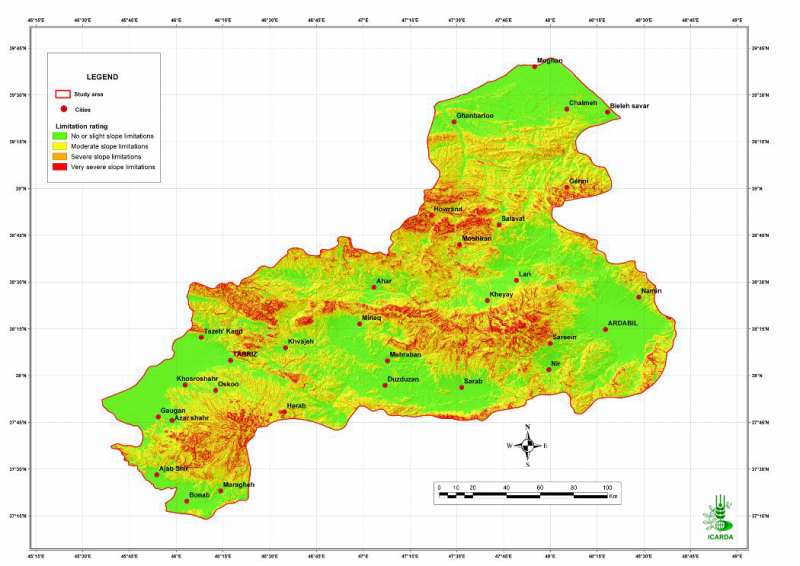
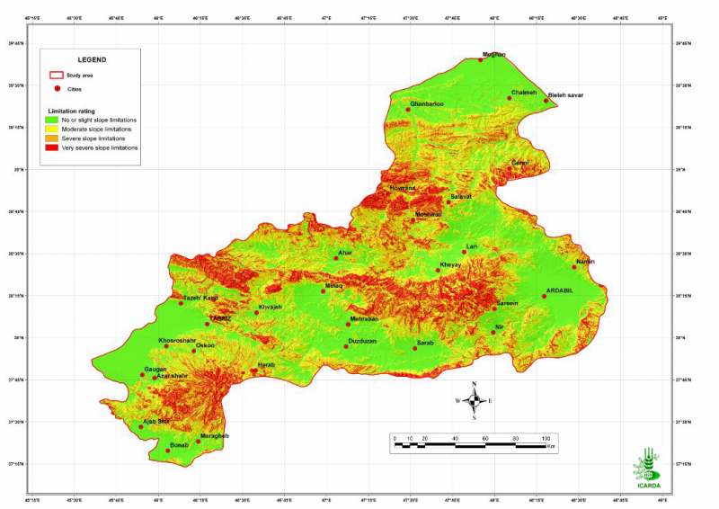
Pilot Area in NW Iran: Adequacy of Topography for Barley
Suitability of topography for barley crops in the Aras and the Daryacheh-Uromieh basins, North-West Iran
Metadataclose[x]
Pilot Area in NW Iran: Adequacy of Topography for Barley
Determine the land suitability for barley crops in the study area
Suitability of topography for barley crops in the Aras and the Daryacheh-Uromieh basins, North-West Iran
International Center for Agricultural Research in the Dry Areas (ICARDA)
2008
suitability, topography, slope, barley
Iran, pilot area, Aras and Daryacheh-Uromieh basins
46.100529
49.162195
34.960947
30.953447
D_WGS_1984
WGS_1984
6378137.000000
298.257224
")
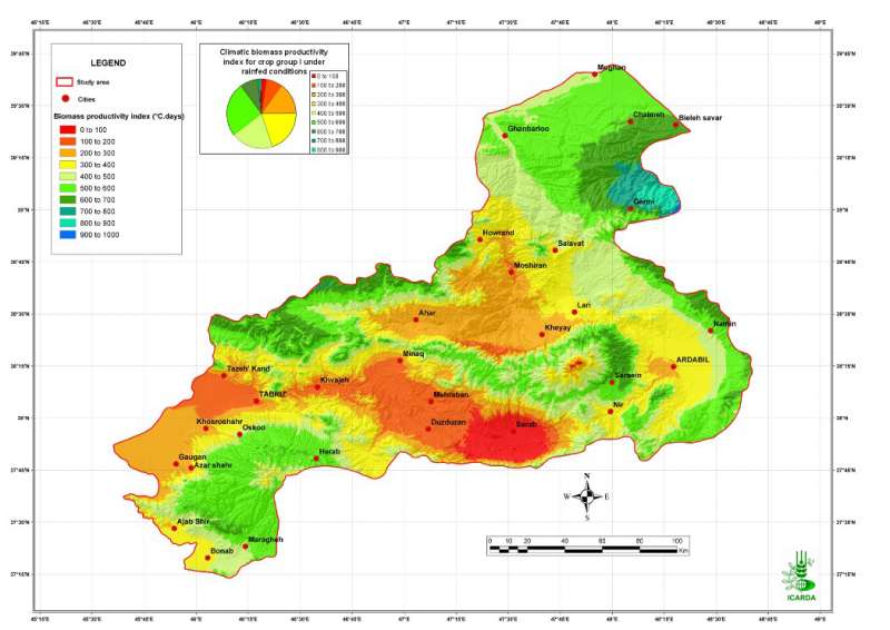
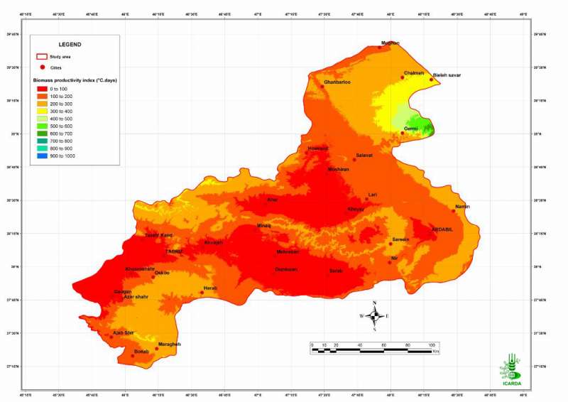
Pilot Area in NW Iran: Biomass Productivity Index (Group I - Rainfed)
Biomass productivity index for crop group I under rainfed conditions in the Aras and the Daryacheh-Uromieh basins, North-West Iran
Metadataclose[x]
Pilot Area in NW Iran: Biomass Productivity Index (Group I - Rainfed)
Characterization of the agro-ecological conditions in the pilot area of Aras and Daryacheh-Uromieh basins (North-West Iran), with the view to determine the land suitability for a range of crop groups in the area
Biomass productivity index for crop group I under rainfed conditions in the Aras and the Daryacheh-Uromieh basins, North-West Iran
International Center for Agricultural Research in the Dry Areas (ICARDA)
2008
agro-ecosystems, climate, biomass productivity index, crop group 1, rainfed
Iran, pilot area, Aras and Daryacheh-Uromieh basins
46.100529
49.162195
34.960947
30.953447
D_WGS_1984
WGS_1984
6378137.000000
298.257224
")
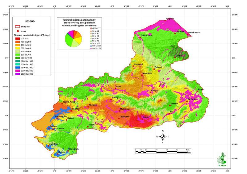
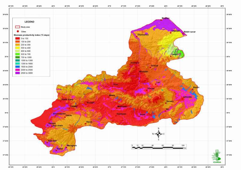
Pilot Area in NW Iran: Biomass Productivity Index (Group I - Irrigated)
Biomass productivity index for crop group I under rainfed and irrigated conditions in the Aras and the Daryacheh-Uromieh basins, North-West Iran
Metadataclose[x]
Pilot Area in NW Iran: Biomass Productivity Index (Group I - Irrigated)
Characterization of the agro-ecological conditions in the pilot area of Aras and Daryacheh-Uromieh basins (North-West Iran), with the view to determine the land suitability for a range of crop groups in the area
Biomass productivity index for crop group I under rainfed and irrigated conditions in the Aras and the Daryacheh-Uromieh basins, North-West Iran
International Center for Agricultural Research in the Dry Areas (ICARDA)
2008
agro-ecosystems, climate, biomass productivity index, crop group 1, irrigated
Iran, pilot area, Aras and Daryacheh-Uromieh basins
46.100529
49.162195
34.960947
30.953447
D_WGS_1984
WGS_1984
6378137.000000
298.257224
")
Pilot Area in NW Iran: Biomass Productivity Index (Group II - Irrigated)
Biomass productivity index for crop group II under rainfed and irrigated conditions in the Aras and the Daryacheh-Uromieh basins, North-West Iran
Metadataclose[x]
Pilot Area in NW Iran: Biomass Productivity Index (Group II - Irrigated)
Characterization of the agro-ecological conditions in the pilot area of Aras and Daryacheh-Uromieh basins (North-West Iran), with the view to determine the land suitability for a range of crop groups in the area
Biomass productivity index for crop group II under rainfed and irrigated conditions in the Aras and the Daryacheh-Uromieh basins, North-West Iran
International Center for Agricultural Research in the Dry Areas (ICARDA)
2008
agro-ecosystems, climate, biomass productivity index, crop group 2, irrigated
Iran, pilot area, Aras and Daryacheh-Uromieh basins
46.100529
49.162195
34.960947
30.953447
D_WGS_1984
WGS_1984
6378137.000000
298.257224
")
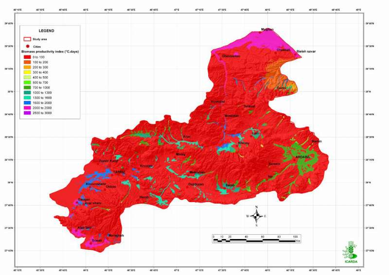
Pilot Area in NW Iran: Biomass Productivity Index (Group III - Rainfed)
Biomass productivity index for crop group III under rainfed conditions in the Aras and the Daryacheh-Uromieh basins, North-West Iran
Metadataclose[x]
Pilot Area in NW Iran: Biomass Productivity Index (Group III - Rainfed)
Characterization of the agro-ecological conditions in the pilot area of Aras and Daryacheh-Uromieh basins (North-West Iran), with the view to determine the land suitability for a range of crop groups in the area
Biomass productivity index for crop group III under rainfed conditions in the Aras and the Daryacheh-Uromieh basins, North-West Iran
International Center for Agricultural Research in the Dry Areas (ICARDA)
2008
agro-ecosystems, climate, biomass productivity index, crop group 3, rainfed
Iran, pilot area, Aras and Daryacheh-Uromieh basins
46.100529
49.162195
34.960947
30.953447
D_WGS_1984
WGS_1984
6378137.000000
298.257224
")
Pilot Area in NW Iran: Biomass Productivity Index (Group III - Irrigated)
Biomass productivity index for crop group III under rainfed and irrigated conditions in the Aras and the Daryacheh-Uromieh basins, North-West Iran
Metadataclose[x]
Pilot Area in NW Iran: Biomass Productivity Index (Group III - Irrigated)
Characterization of the agro-ecological conditions in the pilot area of Aras and Daryacheh-Uromieh basins (North-West Iran), with the view to determine the land suitability for a range of crop groups in the area
Biomass productivity index for crop group III under rainfed and irrigated conditions in the Aras and the Daryacheh-Uromieh basins, North-West Iran
International Center for Agricultural Research in the Dry Areas (ICARDA)
2008
agro-ecosystems, climate, biomass productivity index, crop group 3, irrigated
Iran, pilot area, Aras and Daryacheh-Uromieh basins
46.100529
49.162195
34.960947
30.953447
D_WGS_1984
WGS_1984
6378137.000000
298.257224
")
Pilot Area in NW Iran: Biomass Productivity Index (Group IV - Rainfed)
Biomass productivity index for crop group IV under rainfed conditions in the Aras and the Daryacheh-Uromieh basins, North-West Iran
Metadataclose[x]
Pilot Area in NW Iran: Biomass Productivity Index (Group IV - Rainfed)
Characterization of the agro-ecological conditions in the pilot area of Aras and Daryacheh-Uromieh basins (North-West Iran), with the view to determine the land suitability for a range of crop groups in the area
Biomass productivity index for crop group IV under rainfed conditions in the Aras and the Daryacheh-Uromieh basins, North-West Iran
International Center for Agricultural Research in the Dry Areas (ICARDA)
2008
agro-ecosystems, climate, biomass productivity index, crop group 4, rainfed
Iran, pilot area, Aras and Daryacheh-Uromieh basins
46.100529
49.162195
34.960947
30.953447
D_WGS_1984
WGS_1984
6378137.000000
298.257224
")
Pilot Area in NW Iran: Biomass Productivity Index (Group IV - Irrigated)
Biomass productivity index for crop group IV under rainfed and irrigated conditions in the Aras and the Daryacheh-Uromieh basins, North-West Iran
Metadataclose[x]
Pilot Area in NW Iran: Biomass Productivity Index (Group IV - Irrigated)
Characterization of the agro-ecological conditions in the pilot area of Aras and Daryacheh-Uromieh basins (North-West Iran), with the view to determine the land suitability for a range of crop groups in the area
Biomass productivity index for crop group IV under rainfed and irrigated conditions in the Aras and the Daryacheh-Uromieh basins, North-West Iran
International Center for Agricultural Research in the Dry Areas (ICARDA)
2008
agro-ecosystems, climate, biomass productivity index, crop group 4, irrigated
Iran, pilot area, Aras and Daryacheh-Uromieh basins
46.100529
49.162195
34.960947
30.953447
D_WGS_1984
WGS_1984
6378137.000000
298.257224

Pilot Area in NW Iran: Adequacy of Temperature for Chickpea
Suitability of temperature for chickpea crops in the Aras and the Daryacheh-Uromieh basins, North-West Iran. The suitability is determined by crop-specific thresholds defined on a degree.days scale.
Metadataclose[x]
Pilot Area in NW Iran: Adequacy of Temperature for Chickpea
Determine the climate and the land suitability for chickpea crops in the study area
Suitability of temperature for chickpea crops in the Aras and the Daryacheh-Uromieh basins, North-West Iran. The suitability is determined by crop-specific thresholds defined on a degree.days scale.
International Center for Agricultural Research in the Dry Areas (ICARDA)
2008
suitability, climate, temperature, chickpea
Iran, pilot area, Aras and Daryacheh-Uromieh basins
46.100529
49.162195
34.960947
30.953447
D_WGS_1984
WGS_1984
6378137.000000
298.257224

Pilot Area in NW Iran: Adequacy of Climate for Chickpea
Suitability of climate conditions (temperature and precipitation) for chickpea crops in the Aras and the Daryacheh-Uromieh basins, North-West Iran
Metadataclose[x]
Pilot Area in NW Iran: Adequacy of Climate for Chickpea
Determine the land suitability for chickpea crops in the study area
Suitability of climate conditions (temperature and precipitation) for chickpea crops in the Aras and the Daryacheh-Uromieh basins, North-West Iran
International Center for Agricultural Research in the Dry Areas (ICARDA)
2008
suitability, climate, temperature, precipitation, chickpea
Iran, pilot area, Aras and Daryacheh-Uromieh basins
46.100529
49.162195
34.960947
30.953447
D_WGS_1984
WGS_1984
6378137.000000
298.257224

Pilot Area in NW Iran: Unsuitable Land for Chickpea
Percentage of unsuitable land (all factors combined) for chickpea crops in the Aras and the Daryacheh-Uromieh basins, North-West Iran. The factors, climate, soils and topography, are integrated by the method of the most limiting factor.
Metadataclose[x]
Pilot Area in NW Iran: Unsuitable Land for Chickpea
Determine the land suitability for chickpea crops in the study area
Percentage of unsuitable land (all factors combined) for chickpea crops in the Aras and the Daryacheh-Uromieh basins, North-West Iran. The factors, climate, soils and topography, are integrated by the method of the most limiting factor.
International Center for Agricultural Research in the Dry Areas (ICARDA)
2008
suitability, climate, topography, soil, unsuitable land, chickpea
Iran, pilot area, Aras and Daryacheh-Uromieh basins
46.100529
49.162195
34.960947
30.953447
D_WGS_1984
WGS_1984
6378137.000000
298.257224

Pilot Area in NW Iran: Adequacy of Precipitation for Chickpea
Suitability of precipitation for chickpea crops in the Aras and the Daryacheh-Uromieh basins, North-West Iran
Metadataclose[x]
Pilot Area in NW Iran: Adequacy of Precipitation for Chickpea
Determine the climate and the land suitability for chickpea crops in the study area
Suitability of precipitation for chickpea crops in the Aras and the Daryacheh-Uromieh basins, North-West Iran
International Center for Agricultural Research in the Dry Areas (ICARDA)
2008
suitability, climate, precipitation, chickpea
Iran, pilot area, Aras and Daryacheh-Uromieh basins
46.100529
49.162195
34.960947
30.953447
D_WGS_1984
WGS_1984
6378137.000000
298.257224

Pilot Area in NW Iran: Highly Suitable Land for Chickpea
Percentage of highly suitable land (all factors combined) for chickpea crops in the Aras and the Daryacheh-Uromieh basins, North-West Iran. The factors, climate, soils and topography, are integrated by the method of the most limiting factor.
Metadataclose[x]
Pilot Area in NW Iran: Highly Suitable Land for Chickpea
Determine the land suitability for chickpea crops in the study area
Percentage of highly suitable land (all factors combined) for chickpea crops in the Aras and the Daryacheh-Uromieh basins, North-West Iran. The factors, climate, soils and topography, are integrated by the method of the most limiting factor.
International Center for Agricultural Research in the Dry Areas (ICARDA)
2008
suitability, climate, topography, soil, chickpea
Iran, pilot area, Aras and Daryacheh-Uromieh basins
46.100529
49.162195
34.960947
30.953447
D_WGS_1984
WGS_1984
6378137.000000
298.257224

Pilot Area in NW Iran: Moderately Suitable Land for Chickpea
Percentage of moderately suitable land (all factors combined) for chickpea crops in the Aras and the Daryacheh-Uromieh basins, North-West Iran. The factors, climate, soils and topography, are integrated by the method of the most limiting factor.
Metadataclose[x]
Pilot Area in NW Iran: Moderately Suitable Land for Chickpea
Determine the land suitability for chickpea crops in the study area
Percentage of moderately suitable land (all factors combined) for chickpea crops in the Aras and the Daryacheh-Uromieh basins, North-West Iran. The factors, climate, soils and topography, are integrated by the method of the most limiting factor.
International Center for Agricultural Research in the Dry Areas (ICARDA)
2008
suitability, climate, topography, soil, chickpea
Iran, pilot area, Aras and Daryacheh-Uromieh basins
46.100529
49.162195
34.960947
30.953447
D_WGS_1984
WGS_1984
6378137.000000
298.257224

Pilot Area in NW Iran: Marginally Suitable Land for Chickpea
Percentage of marginally suitable land (all factors combined) for chickpea crops in the Aras and the Daryacheh-Uromieh basins, North-West Iran. The factors, climate, soils and topography, are integrated by the method of the most limiting factor.
Metadataclose[x]
Pilot Area in NW Iran: Marginally Suitable Land for Chickpea
Determine the land suitability for chickpea crops in the study area
Percentage of marginally suitable land (all factors combined) for chickpea crops in the Aras and the Daryacheh-Uromieh basins, North-West Iran. The factors, climate, soils and topography, are integrated by the method of the most limiting factor.
International Center for Agricultural Research in the Dry Areas (ICARDA)
2008
suitability, climate, topography, soil, chickpea
Iran, pilot area, Aras and Daryacheh-Uromieh basins
46.100529
49.162195
34.960947
30.953447
D_WGS_1984
WGS_1984
6378137.000000
298.257224

Pilot Area in NW Iran: Suitable Land for Chickpea
Percentage of highly and moderately suitable land (all factors combined) for chickpea crops in the Aras and the Daryacheh-Uromieh basins, North-West Iran. The factors, climate, soils and topography, are integrated by the method of the most limiting factor.
Metadataclose[x]
Pilot Area in NW Iran: Suitable Land for Chickpea
Determine the land suitability for chickpea crops in the study area
Percentage of highly and moderately suitable land (all factors combined) for chickpea crops in the Aras and the Daryacheh-Uromieh basins, North-West Iran. The factors, climate, soils and topography, are integrated by the method of the most limiting factor.
International Center for Agricultural Research in the Dry Areas (ICARDA)
2008
suitability, climate, topography, soil, suitable land, chickpea
Iran, pilot area, Aras and Daryacheh-Uromieh basins
46.100529
49.162195
34.960947
30.953447
D_WGS_1984
WGS_1984
6378137.000000
298.257224

Pilot Area in NW Iran: Adequacy of Topography for Chickpea
Suitability of topography for chickpea crops in the Aras and the Daryacheh-Uromieh basins, North-West Iran
Metadataclose[x]
Pilot Area in NW Iran: Adequacy of Topography for Chickpea
Determine the land suitability for chickpea crops in the study area
Suitability of topography for chickpea crops in the Aras and the Daryacheh-Uromieh basins, North-West Iran
International Center for Agricultural Research in the Dry Areas (ICARDA)
2008
suitability, topography, slope, chickpea
Iran, pilot area, Aras and Daryacheh-Uromieh basins
46.100529
49.162195
34.960947
30.953447
D_WGS_1984
WGS_1984
6378137.000000
298.257224

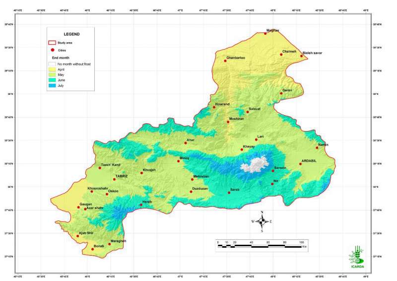
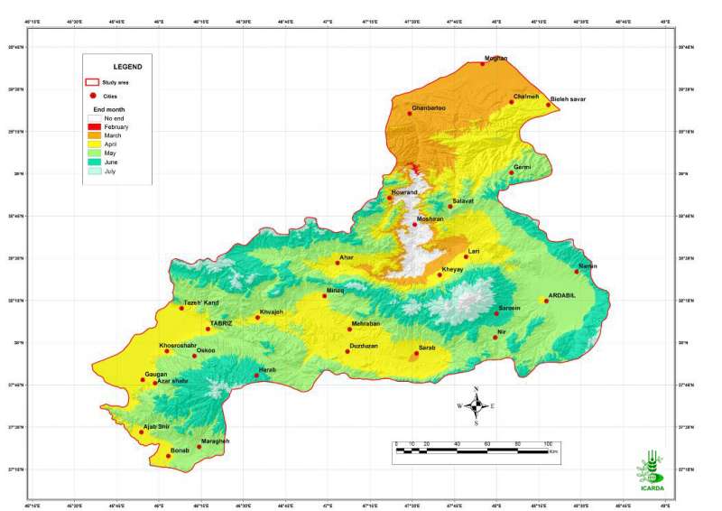
Pilot Area in NW Iran: Frost End Month
Average end month of frost in the Aras and the Daryacheh-Uromieh basins, North-West Iran
Metadataclose[x]
Pilot Area in NW Iran: Frost End Month
Characterization of the agro-ecological conditions in the pilot area of Aras and Daryacheh-Uromieh basins (North-West Iran), with the view to determine the land suitability for a range of crop groups in the area
Average end month of frost in the Aras and the Daryacheh-Uromieh basins, North-West Iran
International Center for Agricultural Research in the Dry Areas (ICARDA)
2008
agro-ecosystems, climate, frost
Iran, pilot area, Aras and Daryacheh-Uromieh basins
46.100529
49.162195
34.960947
30.953447
D_WGS_1984
WGS_1984
6378137.000000
298.257224

Pilot Area in NW Iran: Frost Duration
Annual number of frost days in the Aras and the Daryacheh-Uromieh basins, North-West Iran
Metadataclose[x]
Pilot Area in NW Iran: Frost Duration
Characterization of the agro-ecological conditions in the pilot area of Aras and Daryacheh-Uromieh basins (North-West Iran), with the view to determine the land suitability for a range of crop groups in the area
Annual number of frost days in the Aras and the Daryacheh-Uromieh basins, North-West Iran
International Center for Agricultural Research in the Dry Areas (ICARDA)
2008
agro-ecosystems, climate, frost
Iran, pilot area, Aras and Daryacheh-Uromieh basins
46.100529
49.162195
34.960947
30.953447
D_WGS_1984
WGS_1984
6378137.000000
298.257224

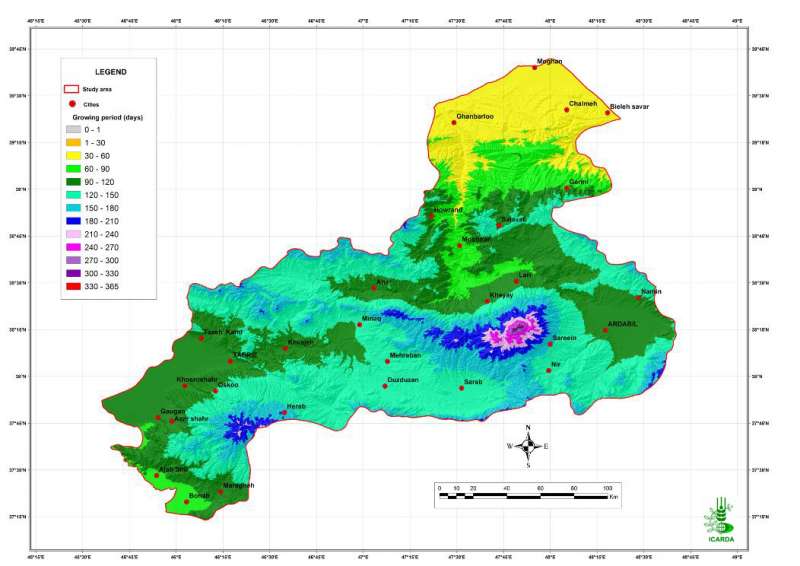
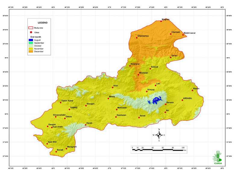
Pilot Area in NW Iran: End of Moisture-Limited Growing Period
End month of the moisture-limited growing period in the Aras and the Daryacheh-Uromieh basins, North-West Iran
Metadataclose[x]
Pilot Area in NW Iran: End of Moisture-Limited Growing Period
Characterization of the agro-ecological conditions in the pilot area of Aras and Daryacheh-Uromieh basins (North-West Iran), with the view to determine the land suitability for a range of crop groups in the area
End month of the moisture-limited growing period in the Aras and the Daryacheh-Uromieh basins, North-West Iran
International Center for Agricultural Research in the Dry Areas (ICARDA)
2008
agro-ecosystems, climate, moisture, growing period
Iran, pilot area, Aras and Daryacheh-Uromieh basins
46.100529
49.162195
34.960947
30.953447
D_WGS_1984
WGS_1984
6378137.000000
298.257224
")
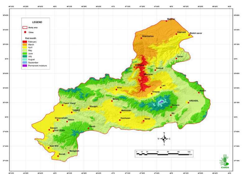
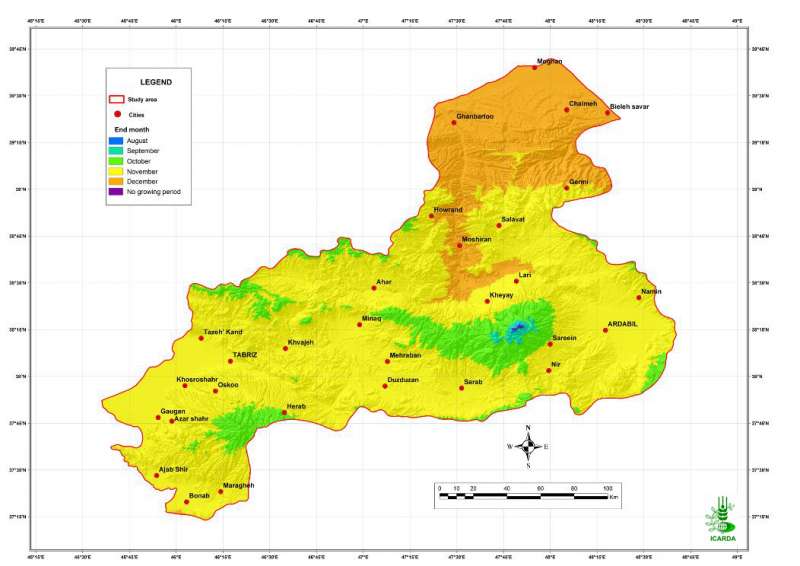
Pilot Area in NW Iran: End of Moisture- and Temperature-Limited Growing Period (1)
End month of the moisture- and temperature-limited growing period in the Aras and the Daryacheh-Uromieh basins, North-West Iran (January to July)
Metadataclose[x]
Pilot Area in NW Iran: End of Moisture- and Temperature-Limited Growing Period (1)
Characterization of the agro-ecological conditions in the pilot area of Aras and Daryacheh-Uromieh basins (North-West Iran), with the view to determine the land suitability for a range of crop groups in the area
End month of the moisture- and temperature-limited growing period in the Aras and the Daryacheh-Uromieh basins, North-West Iran (January to July)
International Center for Agricultural Research in the Dry Areas (ICARDA)
2008
agro-ecosystems, climate, moisture, temperature, growing period
Iran, pilot area, Aras and Daryacheh-Uromieh basins
46.100529
49.162195
34.960947
30.953447
D_WGS_1984
WGS_1984
6378137.000000
298.257224
")
Pilot Area in NW Iran: End of Moisture- and Temperature-Limited Growing Period (2)
End month of the moisture- and temperature-limited growing period in the Aras and the Daryacheh-Uromieh basins, North-West Iran (August to December)
Metadataclose[x]
Pilot Area in NW Iran: End of Moisture- and Temperature-Limited Growing Period (2)
Characterization of the agro-ecological conditions in the pilot area of Aras and Daryacheh-Uromieh basins (North-West Iran), with the view to determine the land suitability for a range of crop groups in the area
End month of the moisture- and temperature-limited growing period in the Aras and the Daryacheh-Uromieh basins, North-West Iran (August to December)
International Center for Agricultural Research in the Dry Areas (ICARDA)
2008
agro-ecosystems, climate, moisture, temperature, growing period
Iran, pilot area, Aras and Daryacheh-Uromieh basins
46.100529
49.162195
34.960947
30.953447
D_WGS_1984
WGS_1984
6378137.000000
298.257224

Pilot Area in NW Iran: End of Temperature-Limited Growing Period
End month of the temperature-limited growing period in the Aras and the Daryacheh-Uromieh basins, North-West Iran
Metadataclose[x]
Pilot Area in NW Iran: End of Temperature-Limited Growing Period
Characterization of the agro-ecological conditions in the pilot area of Aras and Daryacheh-Uromieh basins (North-West Iran), with the view to determine the land suitability for a range of crop groups in the area
End month of the temperature-limited growing period in the Aras and the Daryacheh-Uromieh basins, North-West Iran
International Center for Agricultural Research in the Dry Areas (ICARDA)
2008
agro-ecosystems, climate, temperature, growing period
Iran, pilot area, Aras and Daryacheh-Uromieh basins
46.100529
49.162195
34.960947
30.953447
D_WGS_1984
WGS_1984
6378137.000000
298.257224

Pilot Area in NW Iran: Landforms
Landforms in the Aras and the Daryacheh-Uromieh basins, North-West Iran
Metadataclose[x]
Pilot Area in NW Iran: Landforms
Characterization of the agro-ecological conditions in the pilot area of Aras and Daryacheh-Uromieh basins (North-West Iran), with the view to determine the land suitability for a range of crop groups in the area
Landforms in the Aras and the Daryacheh-Uromieh basins, North-West Iran
International Center for Agricultural Research in the Dry Areas (ICARDA)
2008
agro-ecosystems, landforms
Iran, pilot area, Aras and Daryacheh-Uromieh basins
46.100529
49.162195
34.960947
30.953447
D_WGS_1984
WGS_1984
6378137.000000
298.257224

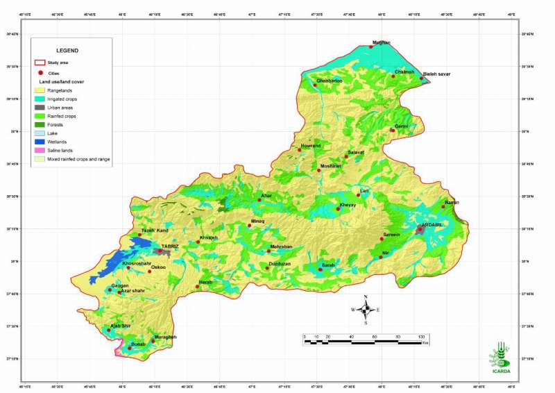
Pilot Area in NW Iran: Land Use/Land Cover
Land use/Land cover in the Aras and the Daryacheh-Uromieh basins, North-West Iran
Metadataclose[x]
Pilot Area in NW Iran: Land Use/Land Cover
Characterization of the agro-ecological conditions in the pilot area of Aras and Daryacheh-Uromieh basins (North-West Iran), with the view to determine the land suitability for a range of crop groups in the area
Land use/Land cover in the Aras and the Daryacheh-Uromieh basins, North-West Iran
International Center for Agricultural Research in the Dry Areas (ICARDA)
2008
agro-ecosystems, land use, land cover
Iran, pilot area, Aras and Daryacheh-Uromieh basins
45.602974
48.672974
39.699621
37.233788
D_WGS_1984
WGS_1984
6378137.000000
298.257224

Pilot Area in NW Iran: Adequacy of Temperature for Lentil
Suitability of temperature for lentil crops in the Aras and the Daryacheh-Uromieh basins, North-West Iran. The suitability is determined by crop-specific thresholds defined on a degree.days scale.
Metadataclose[x]
Pilot Area in NW Iran: Adequacy of Temperature for Lentil
Determine the climate and the land suitability for lentil crops in the study area
Suitability of temperature for lentil crops in the Aras and the Daryacheh-Uromieh basins, North-West Iran. The suitability is determined by crop-specific thresholds defined on a degree.days scale.
International Center for Agricultural Research in the Dry Areas (ICARDA)
2008
suitability, climate, temperature, lentil
Iran, pilot area, Aras and Daryacheh-Uromieh basins
46.100529
49.162195
34.960947
30.953447
D_WGS_1984
WGS_1984
6378137.000000
298.257224

Pilot Area in NW Iran: Adequacy of Climate for Lentil
Suitability of climate conditions (temperature and precipitation) for lentil crops in the Aras and the Daryacheh-Uromieh basins, North-West Iran
Metadataclose[x]
Pilot Area in NW Iran: Adequacy of Climate for Lentil
Determine the land suitability for lentil crops in the study area
Suitability of climate conditions (temperature and precipitation) for lentil crops in the Aras and the Daryacheh-Uromieh basins, North-West Iran
International Center for Agricultural Research in the Dry Areas (ICARDA)
2008
suitability, climate, temperature, precipitation, lentil
Iran, pilot area, Aras and Daryacheh-Uromieh basins
46.100529
49.162195
34.960947
30.953447
D_WGS_1984
WGS_1984
6378137.000000
298.257224

Pilot Area in NW Iran: Unsuitable Land for Lentil
Percentage of unsuitable land (all factors combined) for lentil crops in the Aras and the Daryacheh-Uromieh basins, North-West Iran. The factors, climate, soils and topography, are integrated by the method of the most limiting factor.
Metadataclose[x]
Pilot Area in NW Iran: Unsuitable Land for Lentil
Determine the land suitability for lentil crops in the study area
Percentage of unsuitable land (all factors combined) for lentil crops in the Aras and the Daryacheh-Uromieh basins, North-West Iran. The factors, climate, soils and topography, are integrated by the method of the most limiting factor.
International Center for Agricultural Research in the Dry Areas (ICARDA)
2008
suitability, climate, topography, soil, unsuitable land, lentil
Iran, pilot area, Aras and Daryacheh-Uromieh basins
46.100529
49.162195
34.960947
30.953447
D_WGS_1984
WGS_1984
6378137.000000
298.257224

Pilot Area in NW Iran: Adequacy of Precipitation for Lentil
Suitability of precipitation for lentil crops in the Aras and the Daryacheh-Uromieh basins, North-West Iran
Metadataclose[x]
Pilot Area in NW Iran: Adequacy of Precipitation for Lentil
Determine the climate and the land suitability for lentil crops in the study area
Suitability of precipitation for lentil crops in the Aras and the Daryacheh-Uromieh basins, North-West Iran
International Center for Agricultural Research in the Dry Areas (ICARDA)
2008
suitability, climate, precipitation, lentil
Iran, pilot area, Aras and Daryacheh-Uromieh basins
46.100529
49.162195
34.960947
30.953447
D_WGS_1984
WGS_1984
6378137.000000
298.257224

Pilot Area in NW Iran: Highly Suitable Land for Lentil
Percentage of highly suitable land (all factors combined) for lentil crops in the Aras and the Daryacheh-Uromieh basins, North-West Iran. The factors, climate, soils and topography, are integrated by the method of the most limiting factor.
Metadataclose[x]
Pilot Area in NW Iran: Highly Suitable Land for Lentil
Determine the land suitability for lentil crops in the study area
Percentage of highly suitable land (all factors combined) for lentil crops in the Aras and the Daryacheh-Uromieh basins, North-West Iran. The factors, climate, soils and topography, are integrated by the method of the most limiting factor.
International Center for Agricultural Research in the Dry Areas (ICARDA)
2008
suitability, climate, topography, soil, lentil
Iran, pilot area, Aras and Daryacheh-Uromieh basins
46.100529
49.162195
34.960947
30.953447
D_WGS_1984
WGS_1984
6378137.000000
298.257224

Pilot Area in NW Iran: Moderately Suitable Land for Lentil
Percentage of moderately suitable land (all factors combined) for lentil crops in the Aras and the Daryacheh-Uromieh basins, North-West Iran. The factors, climate, soils and topography, are integrated by the method of the most limiting factor.
Metadataclose[x]
Pilot Area in NW Iran: Moderately Suitable Land for Lentil
Determine the land suitability for lentil crops in the study area
Percentage of moderately suitable land (all factors combined) for lentil crops in the Aras and the Daryacheh-Uromieh basins, North-West Iran. The factors, climate, soils and topography, are integrated by the method of the most limiting factor.
International Center for Agricultural Research in the Dry Areas (ICARDA)
2008
suitability, climate, topography, soil, lentil
Iran, pilot area, Aras and Daryacheh-Uromieh basins
46.100529
49.162195
34.960947
30.953447
D_WGS_1984
WGS_1984
6378137.000000
298.257224

Pilot Area in NW Iran: Marginally Suitable Land for Lentil
Percentage of marginally suitable land (all factors combined) for lentil crops in the Aras and the Daryacheh-Uromieh basins, North-West Iran. The factors, climate, soils and topography, are integrated by the method of the most limiting factor.
Metadataclose[x]
Pilot Area in NW Iran: Marginally Suitable Land for Lentil
Determine the land suitability for lentil crops in the study area
Percentage of marginally suitable land (all factors combined) for lentil crops in the Aras and the Daryacheh-Uromieh basins, North-West Iran. The factors, climate, soils and topography, are integrated by the method of the most limiting factor.
International Center for Agricultural Research in the Dry Areas (ICARDA)
2008
suitability, climate, topography, soil, lentil
Iran, pilot area, Aras and Daryacheh-Uromieh basins
46.100529
49.162195
34.960947
30.953447
D_WGS_1984
WGS_1984
6378137.000000
298.257224