


Geoinformatics Solutions for Integrated Agro-ecosystems Research
GIS Data
Maps in: Agro-Ecological Zoning

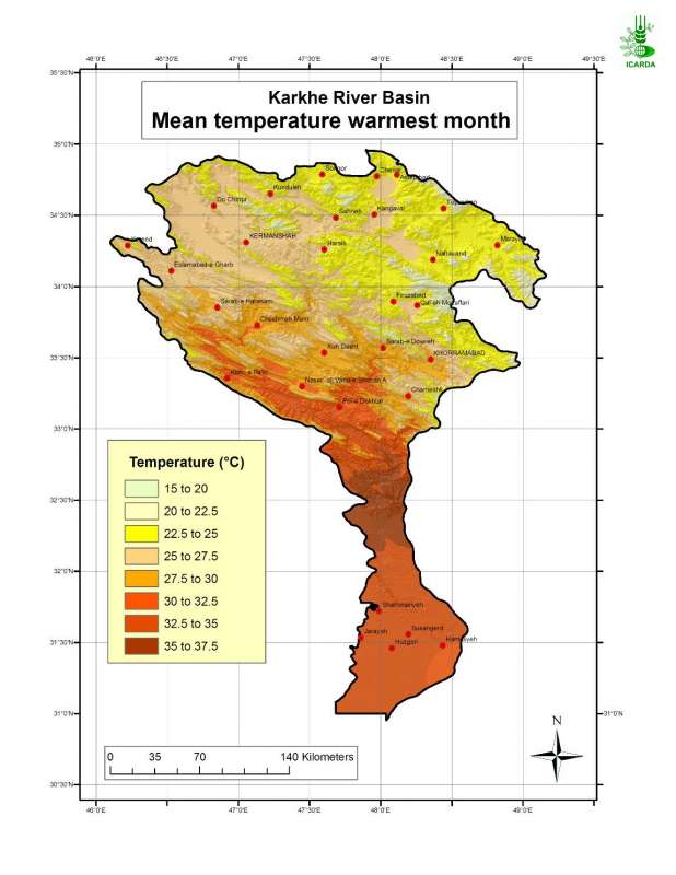
Mean Temperature during the Warmest Month in Karkheh River Basin
Mean temperature during the warmest month in Karkheh river basin
Metadataclose[x]
Mean Temperature during the Warmest Month in Karkheh River Basin
Determine the summer type in the Karkheh river basin. Generate an agroclimatic zones map and an agro-ecological zones map for the area.
Mean temperature during the warmest month in Karkheh river basin
International Center for Agricultural Research in the Dry Areas (ICARDA)
2008
agroclimatic zones, summer type, warmest month
Iran, Karkheh river basin
46.100529
49.162195
34.960947
30.953447
D_WGS_1984
WGS_1984
6378137.000000
298.257224

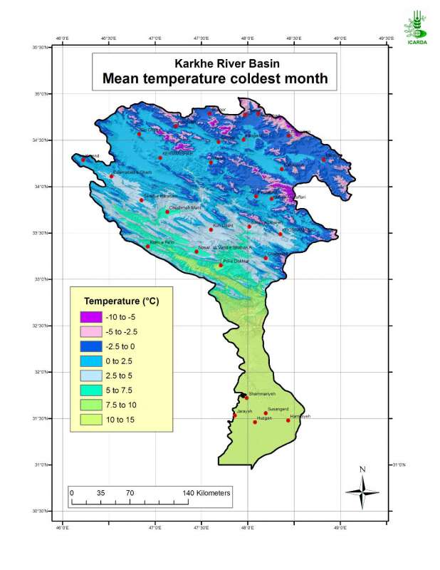
Mean Temperature during the Coldest Month in Karkheh River Basin
Mean temperature during the coldest month in Karkheh river basin
Metadataclose[x]
Mean Temperature during the Coldest Month in Karkheh River Basin
Determine the winter type in the Karkheh river basin. Generate an agroclimatic zones map and an agro-ecological zones map for the area.
Mean temperature during the coldest month in Karkheh river basin
International Center for Agricultural Research in the Dry Areas (ICARDA)
2008
agroclimatic zones, winter type, coldest month
Iran, Karkheh river basin
46.100529
49.162195
34.960947
30.953447
D_WGS_1984
WGS_1984
6378137.000000
298.257224

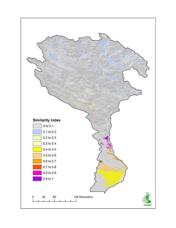
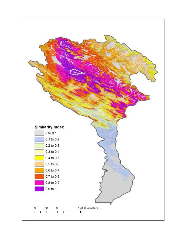
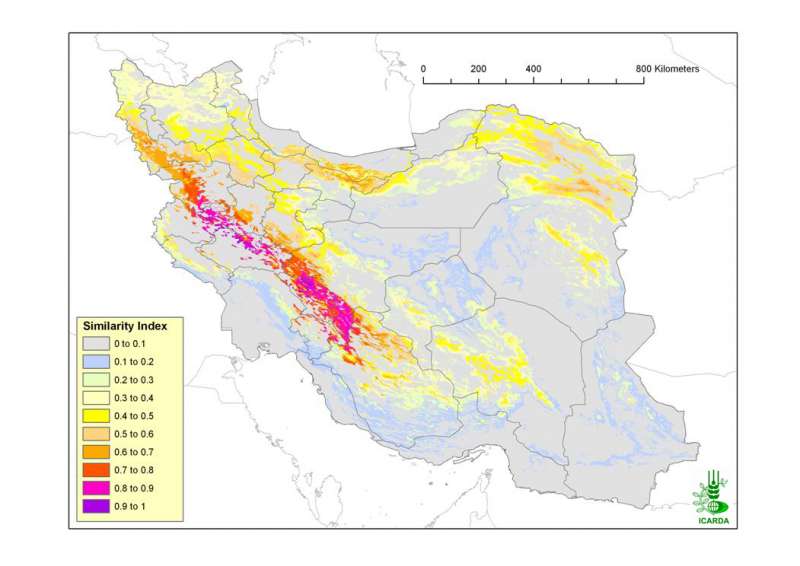
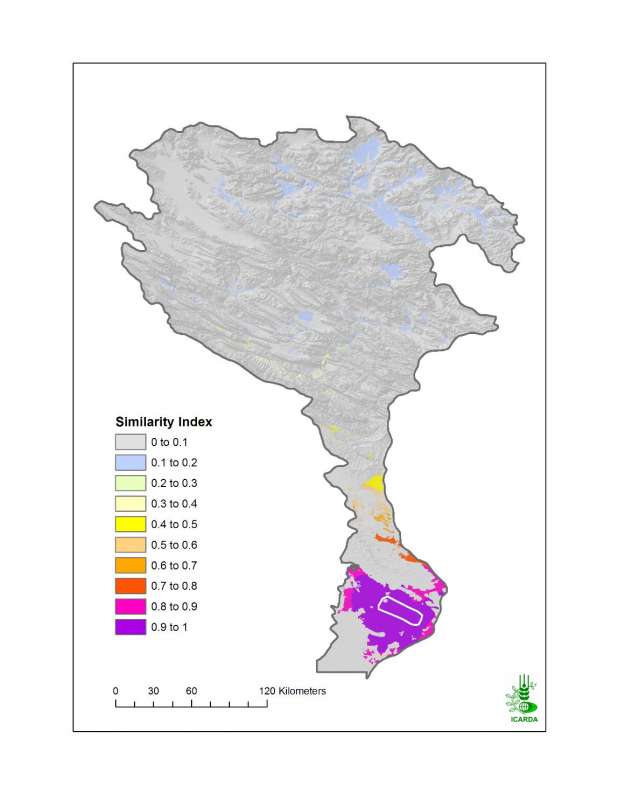
Similarity of KRB in Climate and Land Use/Land Cover to the Sorkhe Benchmark Site
Similarity of KRB in climate and land use/land cover to the Sorkhe benchmark site. The biophysical characterisation of benchmark sites is entirely derived from agro-ecological zones, landforms, land use/land cover and soils maps.
Metadataclose[x]
Similarity of KRB in Climate and Land Use/Land Cover to the Sorkhe Benchmark Site
Assess the Sorkhe benchmark site representativeness of the broader agro-ecological zones of Karkheh river basin
Similarity of KRB in climate and land use/land cover to the Sorkhe benchmark site. The biophysical characterisation of benchmark sites is entirely derived from agro-ecological zones, landforms, land use/land cover and soils maps.
International Center for Agricultural Research in the Dry Areas (ICARDA)
2008
similarity index, climate, land use land cover, benchmark site
Iran, Karkheh river basin, Sorkhe
46.100529
49.162195
34.960947
30.953447
D_WGS_1984
WGS_1984
6378137.000000
298.257224

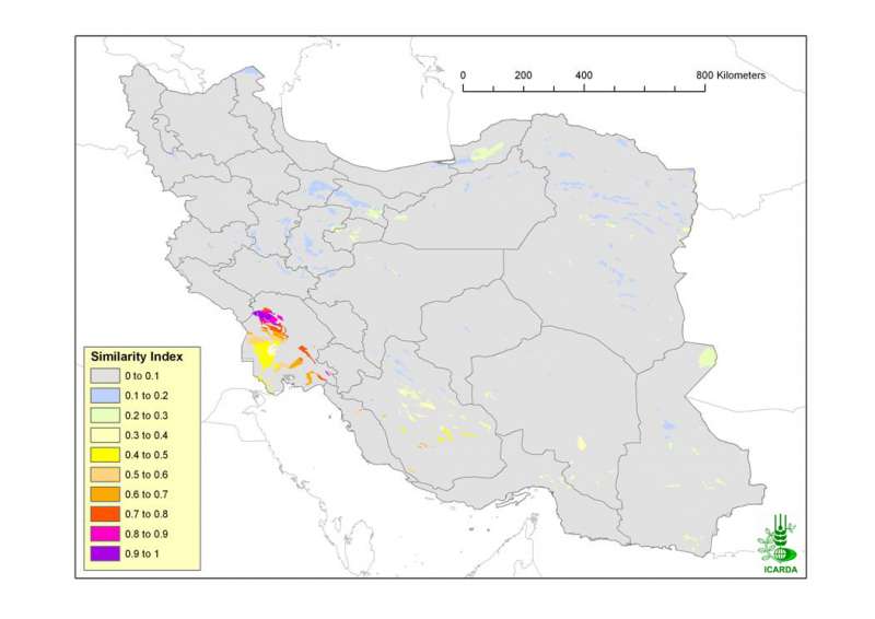
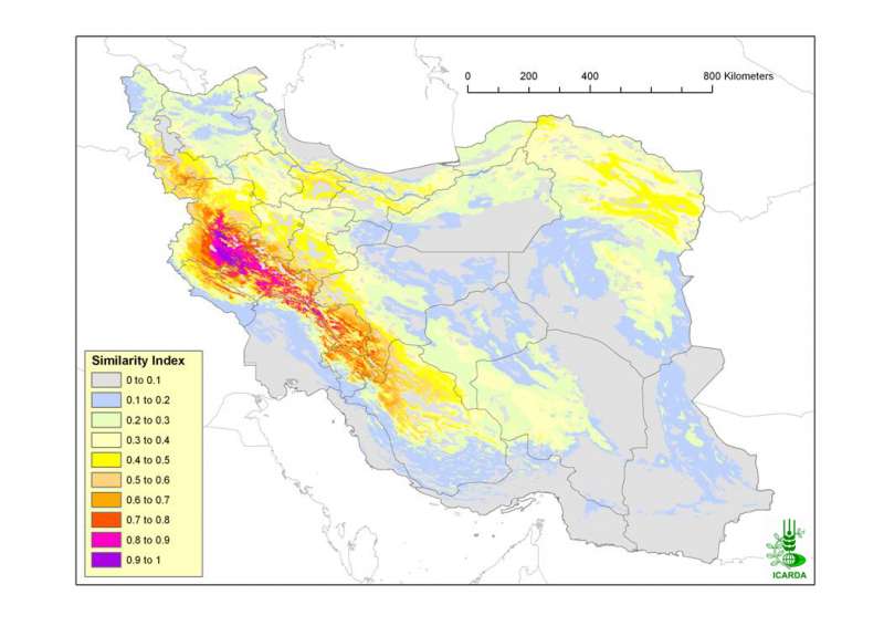
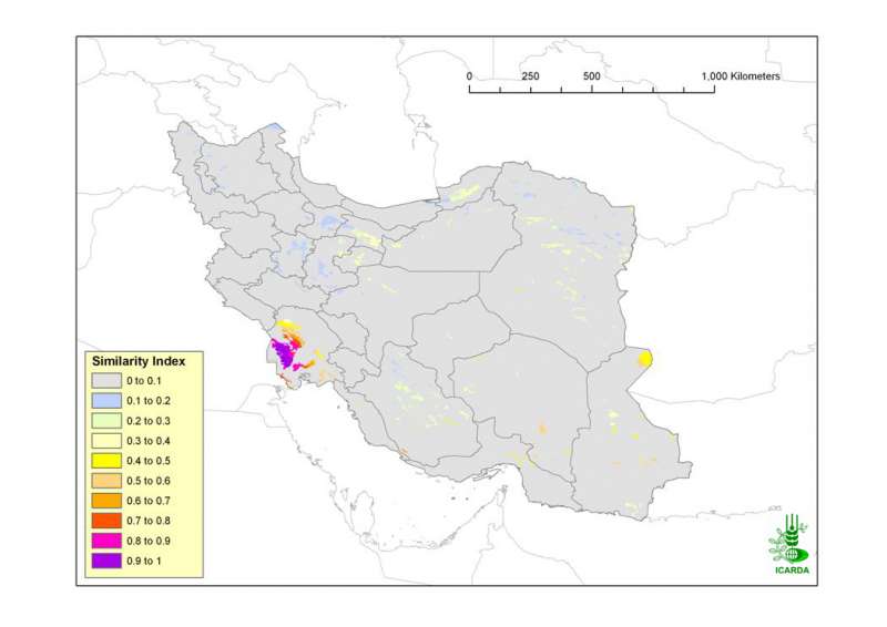
Similarity of Iran in Climate, Land Use/Land Cover and Landforms to the Sorkhe Benchmark Site
Similarity of Iran in climate, land use/land cover and landform to the Sorkhe benchmark site. The biophysical characterisation of benchmark sites is entirely derived from agro-ecological zones, landforms, land use/land cover and soils maps.
Metadataclose[x]
Similarity of Iran in Climate, Land Use/Land Cover and Landforms to the Sorkhe Benchmark Site
Assess the Sorkhe benchmark site representativeness of the broader agro-ecological zones of Iran
Similarity of Iran in climate, land use/land cover and landform to the Sorkhe benchmark site. The biophysical characterisation of benchmark sites is entirely derived from agro-ecological zones, landforms, land use/land cover and soils maps.
International Center for Agricultural Research in the Dry Areas (ICARDA)
2008
similarity index, climate, land use land cover, landforms, benchmark site
Iran, Karkheh river basin, Sorkhe
44.038776
63.313777
39.770641
25.070640
D_WGS_1984
WGS_1984
6378137.000000
298.257224

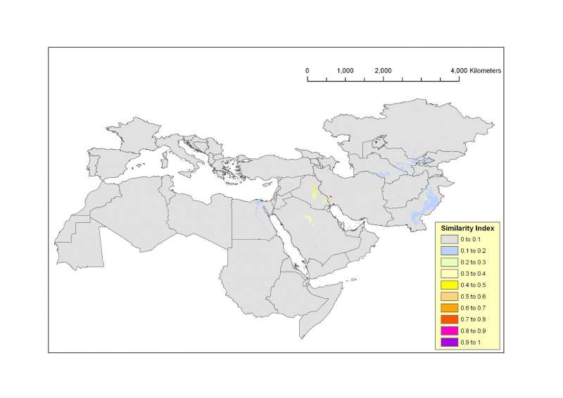
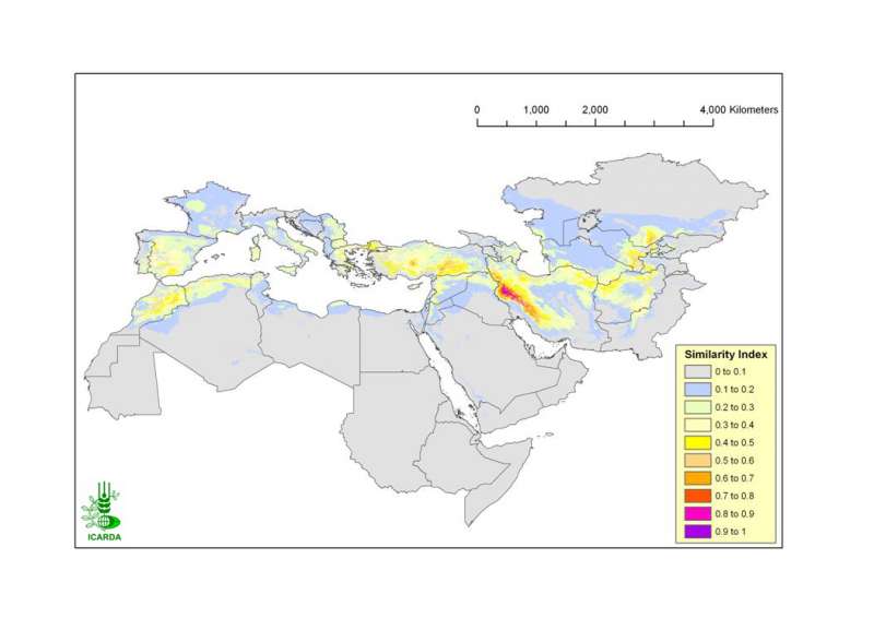
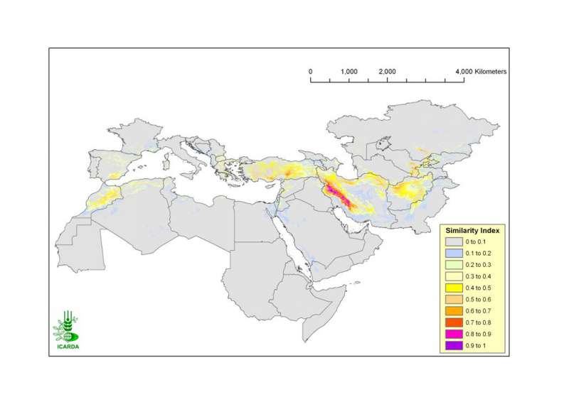
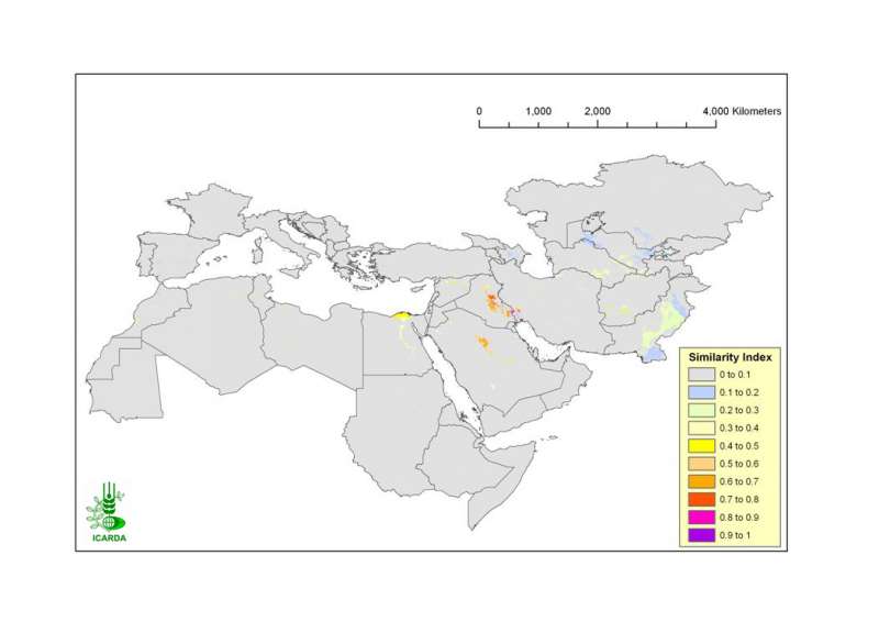
Similarity of CWANA and Northern Mediterranean in Climate, Land Use/Land Cover and Landforms to the Sorkhe Benchmark Site
Similarity of CWANA (Central and West Asia and North Africa) and Northern Mediterranean in climate, land use/land cover and landform to the Sorkhe benchmark site. The biophysical characterisation of benchmark sites is entirely derived from agro-ecological zones, landforms, land use/land cover and soils maps.
Metadataclose[x]
Similarity of CWANA and Northern Mediterranean in Climate, Land Use/Land Cover and Landforms to the Sorkhe Benchmark Site
Assess the Sorkhe benchmark site representativeness of the broader agro-ecological zones of CWANA and Northern Mediterranean
Similarity of CWANA (Central and West Asia and North Africa) and Northern Mediterranean in climate, land use/land cover and landform to the Sorkhe benchmark site. The biophysical characterisation of benchmark sites is entirely derived from agro-ecological zones, landforms, land use/land cover and soils maps.
International Center for Agricultural Research in the Dry Areas (ICARDA)
2008
similarity index, climate, land use land cover, landforms, benchmark site
Iran, Karkheh river basin, Sorkhe, CWANA
46.100529
49.162195
34.960947
30.953447
D_WGS_1984
WGS_1984
6378137.000000
298.257224

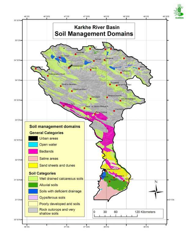
Soil Management Domains in Karkheh River Basin
Simplification of major soil classes into soil management domains in the Karkheh river basin
Metadataclose[x]
Soil Management Domains in Karkheh River Basin
Generate an agro-ecological zones map for the Karkheh River Basin along with agroclimatic zones, land use/land cover and landforms layers.
Simplification of major soil classes into soil management domains in the Karkheh river basin
International Center for Agricultural Research in the Dry Areas (ICARDA)
2008
agro-ecological zones, soil management domains
Iran, Karkheh river basin
46.104568
49.164566
34.953777
30.968779
D_WGS_1984
WGS_1984
6378137.000000
298.257224

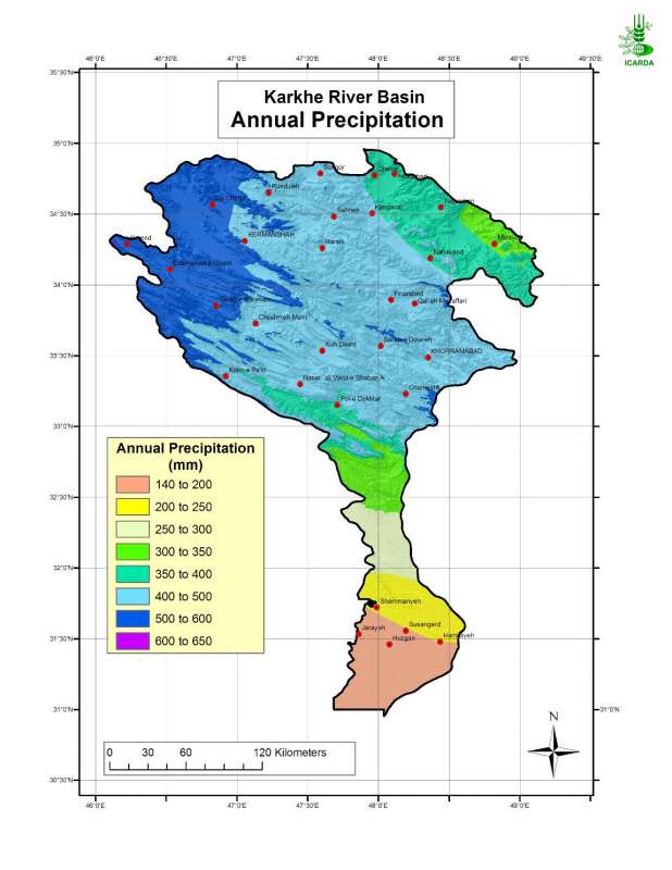
Annual Precipitation in Karkheh River Basin
Mean annual precipitation in Karkheh river basin for the period 1973-1998
Metadataclose[x]
Annual Precipitation in Karkheh River Basin
Generate successively an aridity index map, an agroclimatic zones map and eventually an agro-ecological zones map for the Karkheh River Basin
Mean annual precipitation in Karkheh river basin for the period 1973-1998
International Center for Agricultural Research in the Dry Areas (ICARDA)
2008
precipitation, agroclimatic zones
Iran, Karkheh river basin
46.100529
49.162195
34.960947
30.953447
D_WGS_1984
WGS_1984
6378137.000000
298.257224

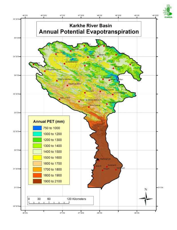
Potential Evapotranspiration in Karkheh River Basin
Annual reference evapotranspiration in Karkheh river basin estimated according to Penman-Monteith method
Metadataclose[x]
Potential Evapotranspiration in Karkheh River Basin
Generate successively an aridity index map, an agroclimatic zones map and eventually an agro-ecological zones map for the Karkheh River Basin
Annual reference evapotranspiration in Karkheh river basin estimated according to Penman-Monteith method
International Center for Agricultural Research in the Dry Areas (ICARDA)
2008
potential evapotranspiration, hargreaves, penman-monteith, agroclimatic zones
Iran, Karkheh river basin
46.100529
49.162195
34.960947
30.953447
D_WGS_1984
WGS_1984
6378137.000000
298.257224

Similarity of KRB in Climate and Land Use/Land Cover to the Merek Benchmark Site
Similarity of KRB in climate and land use/land cover to the Merek benchmark site. The biophysical characterisation of benchmark sites is entirely derived from agro-ecological zones, landforms, land use/land cover and soils maps.
Metadataclose[x]
Similarity of KRB in Climate and Land Use/Land Cover to the Merek Benchmark Site
Assess the Merek benchmark site representativeness of the broader agro-ecological zones of Karkheh river basin
Similarity of KRB in climate and land use/land cover to the Merek benchmark site. The biophysical characterisation of benchmark sites is entirely derived from agro-ecological zones, landforms, land use/land cover and soils maps.
International Center for Agricultural Research in the Dry Areas (ICARDA)
2008
similarity index, climate, land use land cover, benchmark site
Iran, Karkheh river basin, Merek
46.100529
49.161362
34.960114
30.953447
D_WGS_1984
WGS_1984
6378137.000000
298.257224

Similarity of Iran in Climate, Land Use/Land Cover and Landforms to the Merek Benchmark Site
Similarity of Iran in climate, land use/land cover and landform to the Merek benchmark site. The biophysical characterisation of benchmark sites is entirely derived from agro-ecological zones, landforms, land use/land cover and soils maps.
Metadataclose[x]
Similarity of Iran in Climate, Land Use/Land Cover and Landforms to the Merek Benchmark Site
Assess the Merek benchmark site representativeness of the broader agro-ecological zones of Iran
Similarity of Iran in climate, land use/land cover and landform to the Merek benchmark site. The biophysical characterisation of benchmark sites is entirely derived from agro-ecological zones, landforms, land use/land cover and soils maps.
International Center for Agricultural Research in the Dry Areas (ICARDA)
2008
similarity index, climate, land use land cover, landforms, benchmark site
Iran, Karkheh river basin, Merek
44.038776
63.313777
39.770641
25.070640
D_WGS_1984
WGS_1984
6378137.000000
298.257224

Similarity of CWANA and Northern Mediterranean in Climate, Land Use/Land Cover and Landforms to the Merek Benchmark Site
Similarity of CWANA (Central and West Asia and North Africa) and Northern Mediterranean in climate, land use/land cover and landform to the Merek benchmark site. The biophysical characterisation of benchmark sites is entirely derived from agro-ecological zones, landforms, land use/land cover and soils maps.
Metadataclose[x]
Similarity of CWANA and Northern Mediterranean in Climate, Land Use/Land Cover and Landforms to the Merek Benchmark Site
Assess the Merek benchmark site representativeness of the broader agro-ecological zones of CWANA and Northern Mediterranean
Similarity of CWANA (Central and West Asia and North Africa) and Northern Mediterranean in climate, land use/land cover and landform to the Merek benchmark site. The biophysical characterisation of benchmark sites is entirely derived from agro-ecological zones, landforms, land use/land cover and soils maps.
International Center for Agricultural Research in the Dry Areas (ICARDA)
2008
similarity index, climate, land use land cover, landforms, benchmark site
Iran, Karkheh river basin, Merek, CWANA
46.100529
49.162195
34.960947
30.953447
D_WGS_1984
WGS_1984
6378137.000000
298.257224

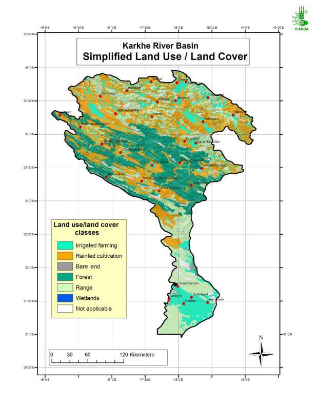
Simplified Land Use/Land Cover in Karkheh River Basin
Simplified land use/land cover in Karkheh river basin
Metadataclose[x]
Simplified Land Use/Land Cover in Karkheh River Basin
Generate an agro-ecological zones map for the Karkheh River Basin along with agroclimatic and soil/landforms layers.
Simplified land use/land cover in Karkheh river basin
International Center for Agricultural Research in the Dry Areas (ICARDA)
2008
land use, land cover
Iran, Karkheh river basin
46.100529
49.161350
34.960098
30.953447
D_WGS_1984
WGS_1984
6378137.000000
298.257224

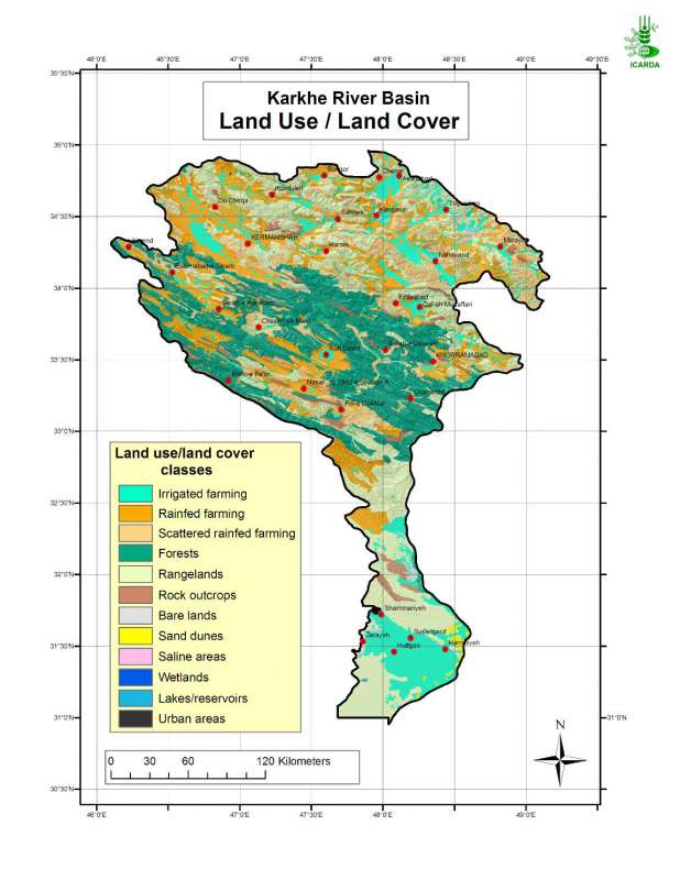
Land Use/Land Cover in Karkheh River Basin
Land use/land cover in Karkheh river basin
Metadataclose[x]
Land Use/Land Cover in Karkheh River Basin
Generate an agro-ecological zones map for the Karkheh River Basin along with agroclimatic and soil/landforms layers.
Land use/land cover in Karkheh river basin
International Center for Agricultural Research in the Dry Areas (ICARDA)
2008
land use, land cover
Iran, Karkheh river basin
46.100529
49.161350
34.960098
30.953447
D_WGS_1984
WGS_1984
6378137.000000
298.257224

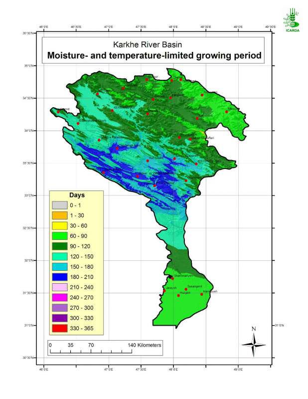
Moisture-limited Growing Period in Karkheh River Basin
Moisture- and temperature-limited growing period in Karkheh river basin
Metadataclose[x]
Moisture-limited Growing Period in Karkheh River Basin
Characterisation of agricultural climates of the Karkheh River Basin
Moisture- and temperature-limited growing period in Karkheh river basin
International Center for Agricultural Research in the Dry Areas (ICARDA)
2008
moisture- and temperature-limited annual growing period, agricultural climates
Iran, Karkheh river basin
46.100529
49.162195
34.960947
30.953447
D_WGS_1984
WGS_1984
6378137.000000
298.257224

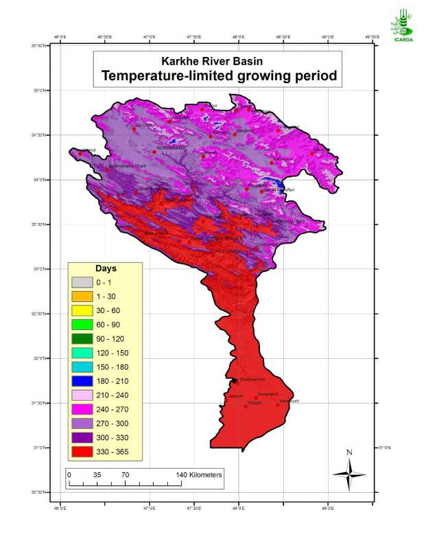
Temperature-limited Growing Period in Karkheh River Basin
Temperature-limited growing period in Karkheh river basin
Metadataclose[x]
Temperature-limited Growing Period in Karkheh River Basin
Characterisation of agricultural climates of the Karkheh River Basin
Temperature-limited growing period in Karkheh river basin
International Center for Agricultural Research in the Dry Areas (ICARDA)
2008
temperature-limited annual growing period, agricultural climates
Iran, Karkheh river basin
46.100529
49.162195
34.960947
30.953447
D_WGS_1984
WGS_1984
6378137.000000
298.257224

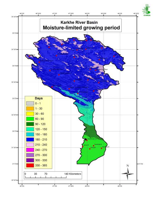
Moisture-limited Growing Period in Karkheh River Basin
Moisture-limited growing period in Karkheh river basin
Metadataclose[x]
Moisture-limited Growing Period in Karkheh River Basin
Characterisation of agricultural climates of the Karkheh River Basin
Moisture-limited growing period in Karkheh river basin
International Center for Agricultural Research in the Dry Areas (ICARDA)
2008
moisture-limited annual growing period, agricultural climates
Iran, Karkheh river basin
46.100529
49.162195
34.960947
30.953447
D_WGS_1984
WGS_1984
6378137.000000
298.257224

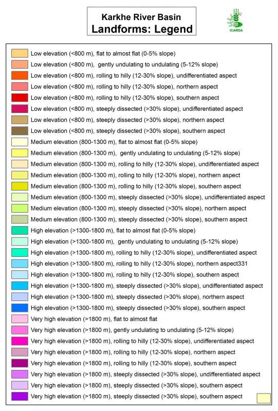
Landforms in Karkheh river basin - Sub-zone C
Landforms in the Southern agricultural region of Karkheh river basin (Sub-zone C)
Metadataclose[x]
Landforms in Karkheh river basin - Sub-zone C
Observe the structure of different landscapes within the basin
Landforms in the Southern agricultural region of Karkheh river basin (Sub-zone C)
International Center for Agricultural Research in the Dry Areas (ICARDA)
2008
landform
Iran, Karkheh river basin, Sub-zone C
47.589641
48.612141
33.040114
30.953447
D_WGS_1984
WGS_1984
6378137.000000
298.257224
Landforms in Karkheh river basin - Sub-zone A
Landforms in the Northern agricultural region of Karkheh river basin (Sub-zone A)
Metadataclose[x]
Landforms in Karkheh river basin - Sub-zone A
Observe the structure of different landscapes within the basin
Landforms in the Northern agricultural region of Karkheh river basin (Sub-zone A)
International Center for Agricultural Research in the Dry Areas (ICARDA)
2008
landform
Iran, Karkheh river basin, Sub-zone A
46.349590
49.161257
34.960410
33.349577
D_WGS_1984
WGS_1984
6378137.000000
298.257224
Metadataclose[x]
Landforms in Karkheh river basin
Observe the structure of different landscapes within the basin
Landforms in Karkheh river basin
International Center for Agricultural Research in the Dry Areas (ICARDA)
2008
landform
Iran, Karkheh river basin
46.100529
49.162195
34.960947
30.953447
D_WGS_1984
WGS_1984
6378137.000000
298.257224

Metadataclose[x]
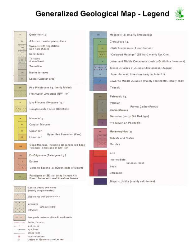
Geology of the Karkheh River Basin
Support the agro-ecosystems characterisation in the Karkheh river basin
Geology of the Karkheh river basin
International Center for Agricultural Research in the Dry Areas (ICARDA)
2008
geology
Iran, Karkheh river basin
46.099693
49.162126
34.961690
30.953412
D_WGS_1984
WGS_1984
6378137.000000
298.257224

Similarity of Iran in Climate, Land Use/Land Cover and Landforms to the Honam Benchmark Site
Similarity of Iran in climate, land use/land cover and landform to the Honam benchmark site. The biophysical characterisation of benchmark sites is entirely derived from agro-ecological zones, landforms, land use/land cover and soils maps.
Metadataclose[x]
Similarity of Iran in Climate, Land Use/Land Cover and Landforms to the Honam Benchmark Site
Assess the Honam benchmark site representativeness of the broader agro-ecological zones of Iran
Similarity of Iran in climate, land use/land cover and landform to the Honam benchmark site. The biophysical characterisation of benchmark sites is entirely derived from agro-ecological zones, landforms, land use/land cover and soils maps.
International Center for Agricultural Research in the Dry Areas (ICARDA)
2008
similarity index, climate, land use land cover, landforms, benchmark site
Iran, Karkheh river basin, Honam
44.038776
63.313777
39.770641
25.070640
D_WGS_1984
WGS_1984
6378137.000000
298.257224

Similarity of CWANA and Northern Mediterranean in Climate, Land Use/Land Cover and Landforms to the Honam Benchmark Site
Similarity of CWANA (Central and West Asia and North Africa) and Northern Mediterranean in climate, land use/land cover and landform to the Honam benchmark site. The biophysical characterisation of benchmark sites is entirely derived from agro-ecological zones, landforms, land use/land cover and soils maps.
Metadataclose[x]
Similarity of CWANA and Northern Mediterranean in Climate, Land Use/Land Cover and Landforms to the Honam Benchmark Site
Assess the Honam benchmark site representativeness of the broader agro-ecological zones of CWANA and Northern Mediterranean
Similarity of CWANA (Central and West Asia and North Africa) and Northern Mediterranean in climate, land use/land cover and landform to the Honam benchmark site. The biophysical characterisation of benchmark sites is entirely derived from agro-ecological zones, landforms, land use/land cover and soils maps.
International Center for Agricultural Research in the Dry Areas (ICARDA)
2008
similarity index, climate, land use land cover, landforms, benchmark site
Iran, Karkheh river basin, Honam, CWANA
46.100529
49.162195
34.960947
30.953447
D_WGS_1984
WGS_1984
6378137.000000
298.257224
")
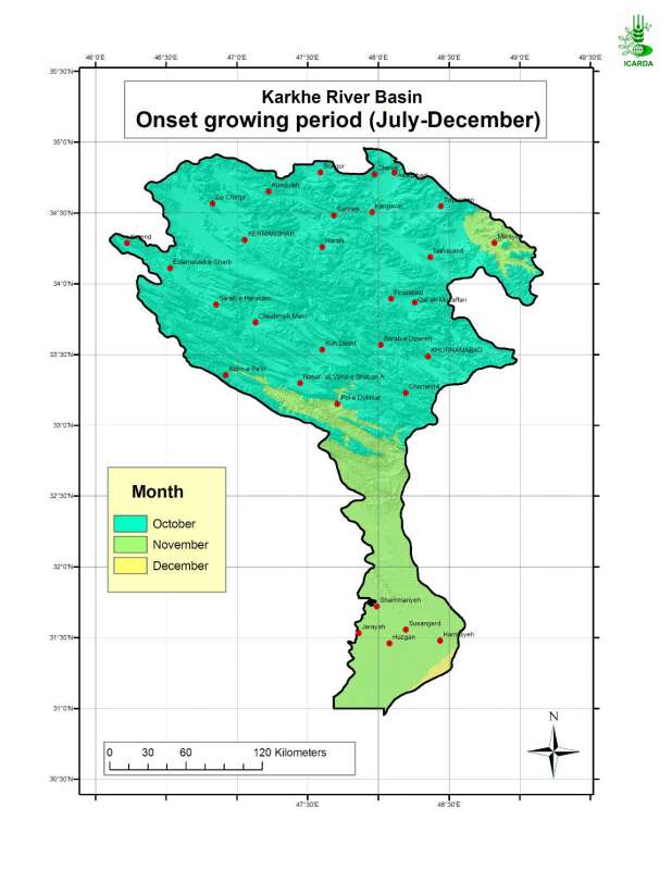
Onset Growing Period in Karkheh River Basin (July-December)
Onset month of the temperature- and moisture-limited growing period in Karkheh river basin (period: July-December)
Metadataclose[x]
Onset Growing Period in Karkheh River Basin (July-December)
Characterization of agricultural climates of the Karkheh River Basin
Onset month of the temperature- and moisture-limited growing period in Karkheh river basin (period: July-December)
International Center for Agricultural Research in the Dry Areas (ICARDA)
2008
moisture- and temperature-limited growing period, growing period onset month, agricultural climates
Iran, Karkheh river basin
46.100529
49.162195
34.960947
30.953447
D_WGS_1984
WGS_1984
6378137.000000
298.257224
")
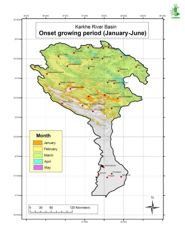
Onset Growing Period in Karkheh River Basin (January-June)
Onset month of the temperature- and moisture-limited growing period in Karkheh river basin (period: January-June)
Metadataclose[x]
Onset Growing Period in Karkheh River Basin (January-June)
Characterization of agricultural climates of the Karkheh River Basin
Onset month of the temperature- and moisture-limited growing period in Karkheh river basin (period: January-June)
International Center for Agricultural Research in the Dry Areas (ICARDA)
2008
moisture- and temperature-limited growing period, growing period onset month, agricultural climates
Iran, Karkheh river basin
46.100529
49.162195
34.960947
30.953447
D_WGS_1984
WGS_1984
6378137.000000
298.257224

Growing Period End in Karkheh River Basin
End month of the temperature- and moisture-limited growing period in Karkheh river basin
Metadataclose[x]
Growing Period End in Karkheh River Basin
Characterization of agricultural climates of the Karkheh River Basin
End month of the temperature- and moisture-limited growing period in Karkheh river basin
International Center for Agricultural Research in the Dry Areas (ICARDA)
2008
moisture- and temperature-limited growing period, growing period end month, agricultural climates
Iran, Karkheh river basin
46.100529
49.162195
34.960947
30.953447
D_WGS_1984
WGS_1984
6378137.000000
298.257224

Similarity of KRB in Climate and Land Use/Land Cover to the Azadegan Benchmark Site
Similarity of KRB in climate and land use/land cover to the Azadegan benchmark site. The biophysical characterisation of benchmark sites is entirely derived from agro-ecological zones, landforms, land use/land cover and soils maps.
Metadataclose[x]
Similarity of KRB in Climate and Land Use/Land Cover to the Azadegan Benchmark Site
Assess the Azadegan benchmark site representativeness of the broader agro-ecological zones of Karkheh river basin
Similarity of KRB in climate and land use/land cover to the Azadegan benchmark site. The biophysical characterisation of benchmark sites is entirely derived from agro-ecological zones, landforms, land use/land cover and soils maps.
International Center for Agricultural Research in the Dry Areas (ICARDA)
2008
similarity index, climate, land use land cover, benchmark site
Iran, Karkheh river basin, Azadegan
46.100529
49.162195
34.960947
30.953447
D_WGS_1984
WGS_1984
6378137.000000
298.257224

Similarity of Iran in Climate, Land Use/Land Cover and Landforms to the Azadegan Benchmark Site
Similarity of Iran in climate, land use/land cover and landform to the Azadegan benchmark site. The biophysical characterisation of benchmark sites is entirely derived from agro-ecological zones, landforms, land use/land cover and soils maps.
Metadataclose[x]
Similarity of Iran in Climate, Land Use/Land Cover and Landforms to the Azadegan Benchmark Site
Assess the Azadegan benchmark site representativeness of the broader agro-ecological zones of Iran
Similarity of Iran in climate, land use/land cover and landform to the Azadegan benchmark site. The biophysical characterisation of benchmark sites is entirely derived from agro-ecological zones, landforms, land use/land cover and soils maps.
International Center for Agricultural Research in the Dry Areas (ICARDA)
2008
similarity index, climate, land use land cover, landforms, benchmark site
Iran, Karkheh river basin, Azadegan
44.038776
63.313777
39.770641
25.070640
D_WGS_1984
WGS_1984
6378137.000000
298.257224

Similarity of CWANA and Northern Mediterranean in Climate, Land Use/Land Cover and Landforms to the Azadegan Benchmark Site
Similarity of CWANA (Central and West Asia and North Africa) and Northern Mediterranean in climate, land use/land cover and landform to the Azadegan benchmark site. The biophysical characterisation of benchmark sites is entirely derived from agro-ecological zones, landforms, land use/land cover and soils maps.
Metadataclose[x]
Similarity of CWANA and Northern Mediterranean in Climate, Land Use/Land Cover and Landforms to the Azadegan Benchmark Site
Assess the Azadegan benchmark site representativeness of the broader agro-ecological zones of CWANA and Northern Mediterranean
Similarity of CWANA (Central and West Asia and North Africa) and Northern Mediterranean in climate, land use/land cover and landform to the Azadegan benchmark site. The biophysical characterisation of benchmark sites is entirely derived from agro-ecological zones, landforms, land use/land cover and soils maps.
International Center for Agricultural Research in the Dry Areas (ICARDA)
2008
similarity index, climate, land use land cover, landforms, benchmark site
Iran, Karkheh river basin, Azadegan, CWANA
46.100529
49.162195
34.960947
30.953447
D_WGS_1984
WGS_1984
6378137.000000
298.257224

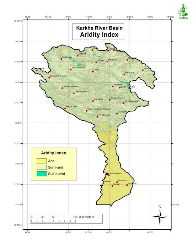
Aridity index in Karkheh river basin
Aridity Index in the Karkheh River Basin
Metadataclose[x]
Aridity index in Karkheh river basin
Determination of the moisture regime in the Karkheh river basin
Aridity Index in the Karkheh River Basin
International Center for Agricultural Research in the Dry Areas (ICARDA)
2008
aridity index, moisture regime, agroclimatic zones
Iran, Karkheh river basin
46.100529
49.162195
34.960947
30.953447
D_WGS_1984
WGS_1984
6378137.000000
298.257224

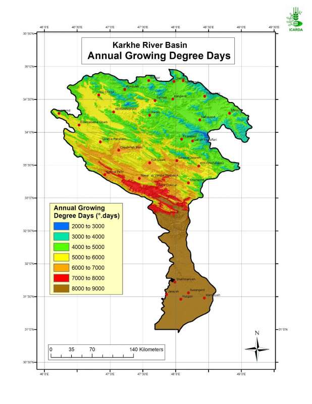
Annual Growing Degree Days in Karkheh River Basin
Annual growing degree-days in Karkheh river basin
Metadataclose[x]
Annual Growing Degree Days in Karkheh River Basin
Characterisation of agricultural climates of the Karkheh River Basin
Annual growing degree-days in Karkheh river basin
International Center for Agricultural Research in the Dry Areas (ICARDA)
2008
annual growing degree days, agricultural climates
Iran, Karkheh river basin
46.100529
49.162195
34.960947
30.953447
D_WGS_1984
WGS_1984
6378137.000000
298.257224

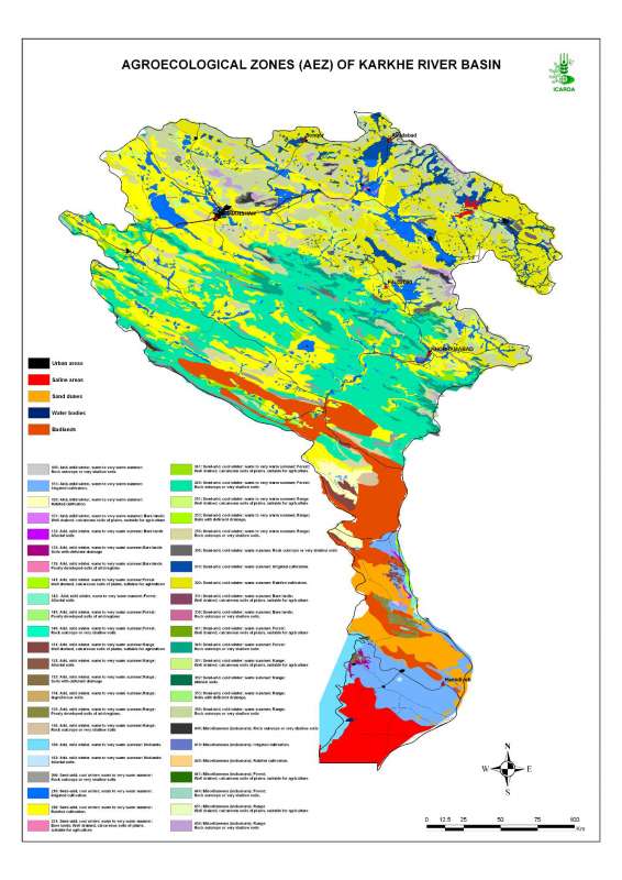
Agro-Ecological Zones in Karheh River Basin
Agro-ecological zones in Karkheh river basin
Metadataclose[x]
Agro-Ecological Zones in Karheh River Basin
Characterization of the agricultural environments in the Karkheh river basin based on water availability, climate, terrain and soil conditions.
Agro-ecological zones in Karkheh river basin
International Center for Agricultural Research in the Dry Areas (ICARDA)
2008
agro-ecological zones, agricultural environments
Iran, Karkheh river basin
46.104568
49.164568
34.953779
30.968779
D_WGS_1984
WGS_1984
6378137.000000
298.257224

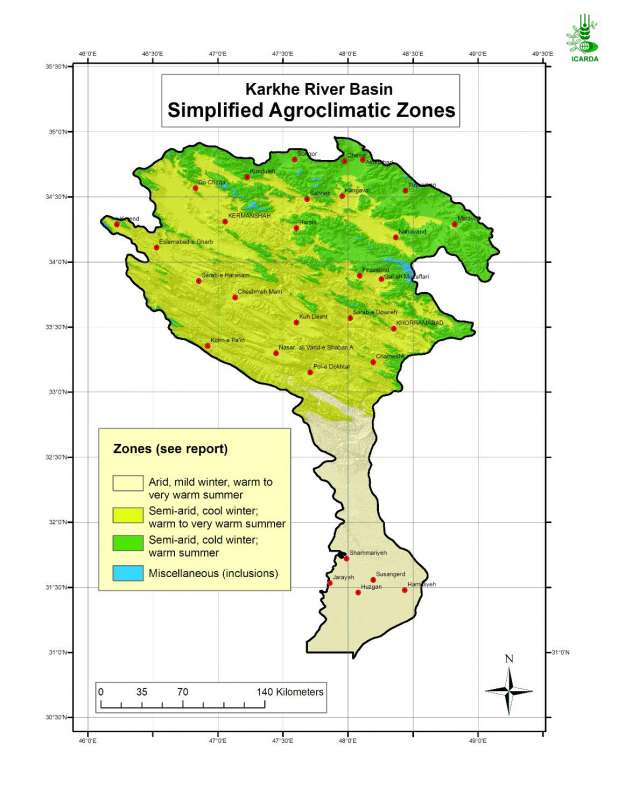
Simplified agroclimatic zones in Karkheh river basin
Simplified Agroclimatic Zones in Karkheh River Basin
Metadataclose[x]
Simplified agroclimatic zones in Karkheh river basin
Generate an agro-ecological zones map for the Karkheh river basin along with land use/land cover and soil/landforms layers.
Simplified Agroclimatic Zones in Karkheh River Basin
International Center for Agricultural Research in the Dry Areas (ICARDA)
2008
simplified agroclimatic zones
Iran, Karkheh river basin
46.100529
49.162195
34.960947
30.953447
D_WGS_1984
WGS_1984
6378137.000000
298.257224

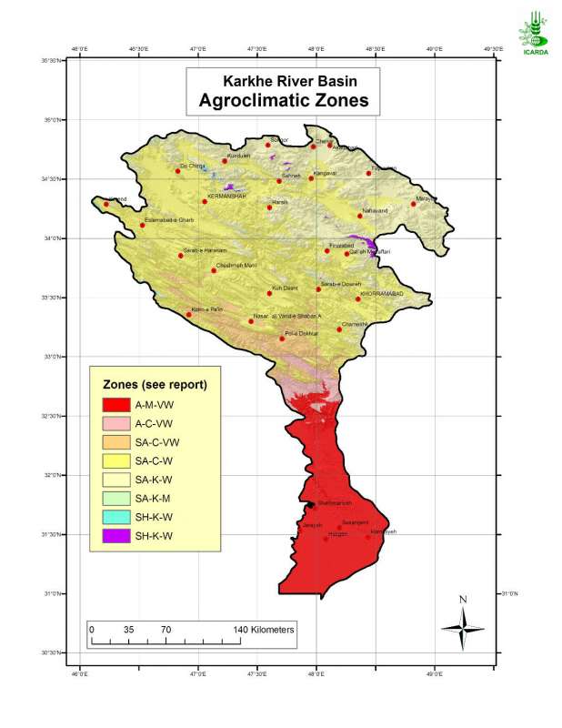
Agroclimatic Zones in Karkheh River Basin
Agroclimatic zones in Karkheh river basin
Metadataclose[x]
Agroclimatic Zones in Karkheh River Basin
Generate an agro-ecological zones map for the Karkheh River Basin along with land use/land cover and soil/landforms layers.
Agroclimatic zones in Karkheh river basin
International Center for Agricultural Research in the Dry Areas (ICARDA)
2008
agroclimatic zones
Iran, Karkheh river basin
46.100529
49.162195
34.960947
30.953447
D_WGS_1984
WGS_1984
6378137.000000
298.257224

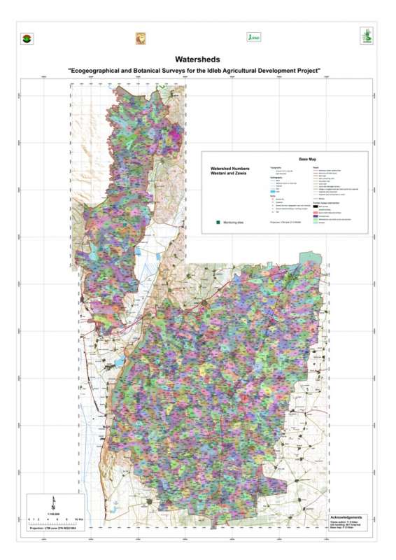
Jebel Zawia: Watersheds
Micro-watersheds (few square km) in the Jebel Zawia area
Metadataclose[x]
Jebel Zawia: Watersheds
Characterisation of the agricultural environment in Jebel Zawia and in Jebel Wastani with a view to develop management plans for areas with valuable plant biodiversity (Idleb Rural Development Project)
Micro-watersheds (few square km) in the Jebel Zawia area
International Center for Agricultural Research in the Dry Areas (ICARDA)
2008
hydrology, watersheds, catchment area
Syria, Idleb, Zawia
36.381332
36.900068
35.919074
35.377151
D_WGS_1984
WGS_1984
6378137.000000
298.257224

Jebel Zawia: Geology
Geological map the Jebel Zawia area extracted from the Technoexport geological map 1:200,000.
Metadataclose[x]
Jebel Zawia: Geology
Characterisation of the agricultural environment in Jebel Zawia and in Jebel Wastani with a view to develop management plans for areas with valuable plant biodiversity (Idleb Rural Development Project)
Geological map the Jebel Zawia area extracted from the Technoexport geological map 1:200,000.
International Center for Agricultural Research in the Dry Areas (ICARDA)
2008
geology, lithology
Syria, Idleb, Zawia
36.381351
36.900066
35.919029
35.377233
D_WGS_1984
WGS_1984
6378137.000000
298.257224

Metadataclose[x]
Jebel Zawia: Drainage
Characterisation of the agricultural environment in Jebel Zawia and in Jebel Wastani with a view to develop management plans for areas with valuable plant biodiversity (Idleb Rural Development Project)
Drainage network (streamlines) in the Jebel Zawia area
International Center for Agricultural Research in the Dry Areas (ICARDA)
2008
hydrology, drainage, streamlines
Syria, Idleb, Zawia
36.314106
36.928177
35.901522
35.378598
D_WGS_1984
WGS_1984
6378137.000000
298.257224

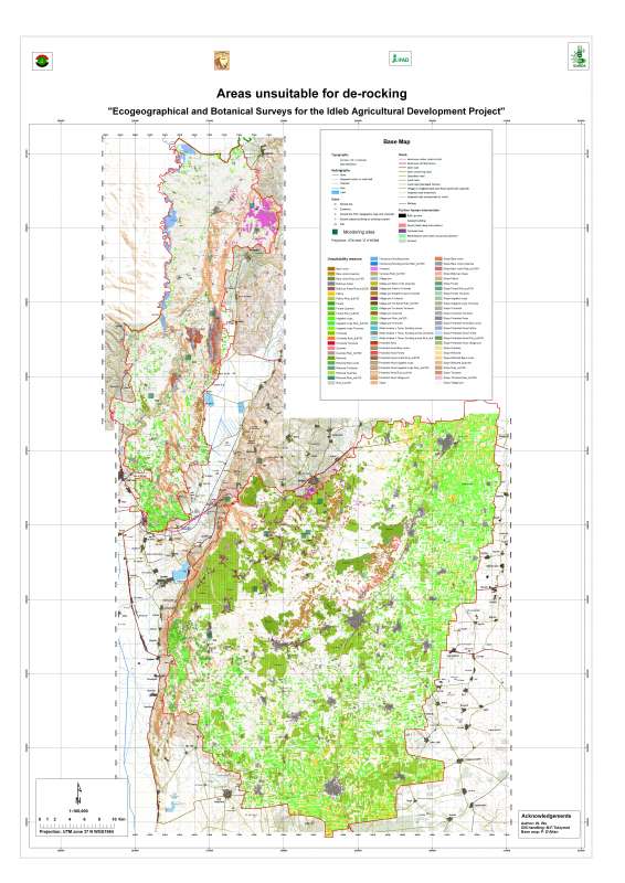
Jebel Zawia Area: Unsuitability for De-Rocking
Unsuitable zones for de-rocking farming system in Jebel Zawia areas
Metadataclose[x]
Jebel Zawia Area: Unsuitability for De-Rocking
Characterisation of the agricultural environment in Jebel Zawia and in Jebel Wastani with a view to develop management plans for areas with valuable plant biodiversity (Idleb Rural Development Project)
Unsuitable zones for de-rocking farming system in Jebel Zawia areas
International Center for Agricultural Research in the Dry Areas (ICARDA)
2008
de-rocking, land reclamation, rock removal
Syria, Idleb, Zawia
36.381890
36.900070
35.900989
35.377096
D_WGS_1984
WGS_1984
6378137.000000
298.257224
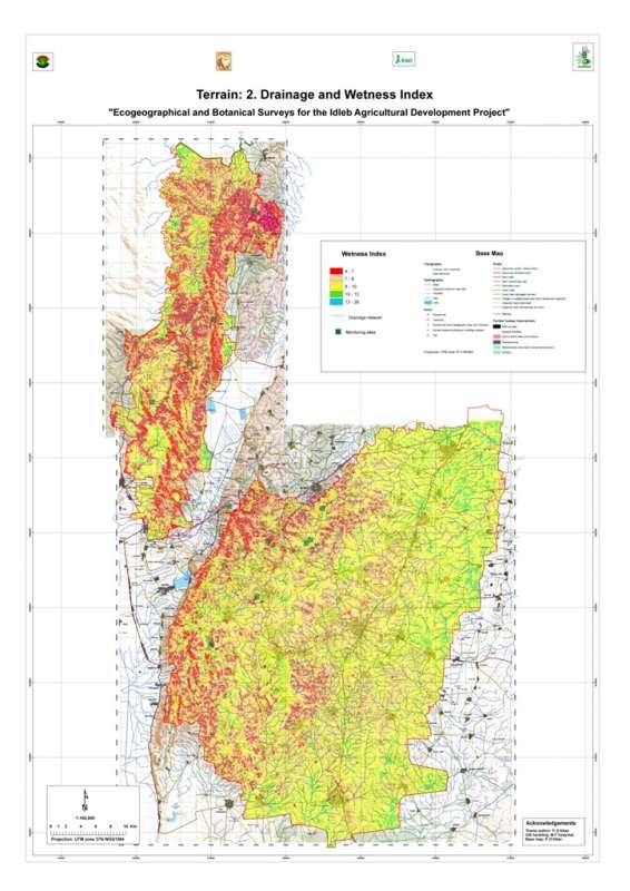
Jebel Zawia: Wetness Index
Wetness index (or compound topographic index) in the Jebel Zawia area. This index quantifies the position of a site in the local landscape, in terms of either run-on or run-off characteristics.
Metadataclose[x]
Jebel Zawia: Wetness Index
Characterisation of the agricultural environment in Jebel Zawia and in Jebel Wastani with a view to develop management plans for areas with valuable plant biodiversity (Idleb Rural Development Project)
Wetness index (or compound topographic index) in the Jebel Zawia area. This index quantifies the position of a site in the local landscape, in terms of either run-on or run-off characteristics.
International Center for Agricultural Research in the Dry Areas (ICARDA)
2008
Wetness index, topography, run-off
Syria, Idleb, Zawia
36.312311
36.928358
35.901540
35.375100
D_WGS_1984
WGS_1984
6378137.000000
298.257224
Jebel Wastani: Watersheds
Micro-watersheds (few square km) in the Jebel Wastani area
Metadataclose[x]
Jebel Wastani: Watersheds
Characterisation of the agricultural environment in Jebel Zawia and in Jebel Wastani with a view to develop management plans for areas with valuable plant biodiversity (Idleb Rural Development Project)
Micro-watersheds (few square km) in the Jebel Wastani area
International Center for Agricultural Research in the Dry Areas (ICARDA)
2008
hydrology, watersheds, catchment area
Syria, Idleb, Wastani
36.291734
36.563779
36.228547
35.744568
D_WGS_1984
WGS_1984
6378137.000000
298.257224
Jebel Wastani: Geology
Geological map the Jebel Wastani area extracted from the Technoexport geological map 1:200,000.
Metadataclose[x]
Jebel Wastani: Geology
Characterisation of the agricultural environment in Jebel Zawia and in Jebel Wastani with a view to develop management plans for areas with valuable plant biodiversity (Idleb Rural Development Project)
Geological map the Jebel Wastani area extracted from the Technoexport geological map 1:200,000.
International Center for Agricultural Research in the Dry Areas (ICARDA)
2008
geology, lithology
Syria, Idleb, Wastani
36.291734
36.563779
36.228547
35.744568
D_WGS_1984
WGS_1984
6378137.000000
298.257224
Jebel Wastani: Drainage
Drainage network (streamlines) in the Jebel Wastani area
Metadataclose[x]
Jebel Wastani: Drainage
Characterisation of the agricultural environment in Jebel Zawia and in Jebel Wastani with a view to develop management plans for areas with valuable plant biodiversity (Idleb Rural Development Project)
Drainage network (streamlines) in the Jebel Wastani area
International Center for Agricultural Research in the Dry Areas (ICARDA)
2008
hydrology, drainage, streamlines
Syria, Idleb, Wastani
36.289765
36.606037
36.243318
35.717470
D_WGS_1984
WGS_1984
6378137.000000
298.257224
Jebel Wastani Area: Unsuitability for De-Rocking
Unsuitable zones for de-rocking farming system in Jebel Wastani area
Metadataclose[x]
Jebel Wastani Area: Unsuitability for De-Rocking
Characterisation of the agricultural environment in Jebel Zawia and in Jebel Wastani with a view to develop management plans for areas with valuable plant biodiversity (Idleb Rural Development Project)
Unsuitable zones for de-rocking farming system in Jebel Wastani area
International Center for Agricultural Research in the Dry Areas (ICARDA)
2008
de-rocking, land reclamation, rock removal
Syria, Idleb, Wastani
36.291599
36.563816
36.228634
35.744399
D_WGS_1984
WGS_1984
6378137.000000
298.257224
Jebel Wastani: Wetness Index
Wetness index (or compound topographic index) in the Jebel Wastani area. This index quantifies the position of a site in the local landscape, in terms of either run-on or run-off characteristics.
Metadataclose[x]
Jebel Wastani: Wetness Index
Characterisation of the agricultural environment in Jebel Zawia and in Jebel Wastani with a view to develop management plans for areas with valuable plant biodiversity (Idleb Rural Development Project)
Wetness index (or compound topographic index) in the Jebel Wastani area. This index quantifies the position of a site in the local landscape, in terms of either run-on or run-off characteristics.
International Center for Agricultural Research in the Dry Areas (ICARDA)
2008
Wetness index, topography, run-off
Syria, Idleb, Wastani
36.282496
36.606109
36.243322
35.717262
D_WGS_1984
WGS_1984
6378137.000000
298.257224

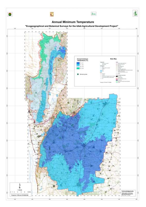
Jebel Zawia: Minimum Temperature
Average minimum temperature in the Jebel Zawia area
Metadataclose[x]
Jebel Zawia: Minimum Temperature
Characterisation of the agricultural environment in Jebel Zawia and in Jebel Wastani with a view to develop management plans for areas with valuable plant biodiversity (Idleb Rural Development Project)
Average minimum temperature in the Jebel Zawia area
International Center for Agricultural Research in the Dry Areas (ICARDA)
2008
climate, maximum temperature
Syria, Idleb, Zawia
36.376094
36.902778
35.928907
35.372429
D_WGS_1984
WGS_1984
6378137.000000
298.257224
Jebel Wastani: Minimum Temperature
Average minimum temperature in the Jebel Wastani area
Metadataclose[x]
Jebel Wastani: Minimum Temperature
Characterisation of the agricultural environment in Jebel Zawia and in Jebel Wastani with a view to develop management plans for areas with valuable plant biodiversity (Idleb Rural Development Project)
Average minimum temperature in the Jebel Wastani area
International Center for Agricultural Research in the Dry Areas (ICARDA)
2008
climate, minimum temperature
Syria, Idleb, Wastani
36.286639
36.566675
36.230450
35.740842
D_WGS_1984
WGS_1984
6378137.000000
298.257224

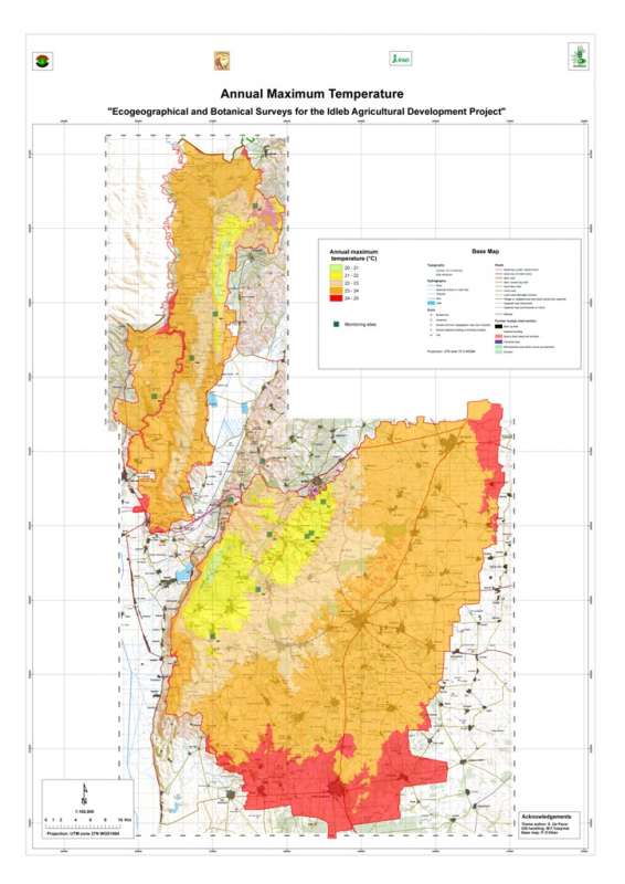
Jebel Zawia: Maximum Temperature
Average maximum temperature in the Jebel Zawia area
Metadataclose[x]
Jebel Zawia: Maximum Temperature
Characterisation of the agricultural environment in Jebel Zawia and in Jebel Wastani with a view to develop management plans for areas with valuable plant biodiversity (Idleb Rural Development Project)
Average maximum temperature in the Jebel Zawia area
International Center for Agricultural Research in the Dry Areas (ICARDA)
2008
climate, maximum temperature
Syria, Idleb, Zawia
36.376094
36.902778
35.928907
35.372429
D_WGS_1984
WGS_1984
6378137.000000
298.257224
Jebel Wastani: Maximum Temperature
Average maximum temperature in the Jebel Wastani area
Metadataclose[x]
Jebel Wastani: Maximum Temperature
Characterisation of the agricultural environment in Jebel Zawia and in Jebel Wastani with a view to develop management plans for areas with valuable plant biodiversity (Idleb Rural Development Project)
Average maximum temperature in the Jebel Wastani area
International Center for Agricultural Research in the Dry Areas (ICARDA)
2008
climate, maximum temperature
Syria, Idleb, Wastani
36.286639
36.566675
36.230450
35.740842
D_WGS_1984
WGS_1984
6378137.000000
298.257224

Jebel Zawia: Terrain
Terrain units the Jebel Zawia area. Terrain units are determined by combination of elevation, slope and aspect.
Metadataclose[x]
Jebel Zawia: Terrain
Characterisation of the agricultural environment in Jebel Zawia and in Jebel Wastani with a view to develop management plans for areas with valuable plant biodiversity (Idleb Rural Development Project)
Terrain units the Jebel Zawia area. Terrain units are determined by combination of elevation, slope and aspect.
International Center for Agricultural Research in the Dry Areas (ICARDA)
2008
slope, aspect, elevation, terrain
Syria, Idleb, Zawia
36.381926
36.900061
35.901056
35.377164
D_WGS_1984
WGS_1984
6378137.000000
298.257224
Jebel Wastani: Terrain
Terrain units the Jebel Wastani area. Terrain units are determined by combination of elevation, slope and aspect.
Metadataclose[x]
Jebel Wastani: Terrain
Characterisation of the agricultural environment in Jebel Zawia and in Jebel Wastani with a view to develop management plans for areas with valuable plant biodiversity (Idleb Rural Development Project)
Terrain units the Jebel Wastani area. Terrain units are determined by combination of elevation, slope and aspect.
International Center for Agricultural Research in the Dry Areas (ICARDA)
2008
slope, aspect, elevation, terrain
Syria, Idleb, Wastani
36.291735
36.563832
36.228515
35.744568
D_WGS_1984
WGS_1984
6378137.000000
298.257224

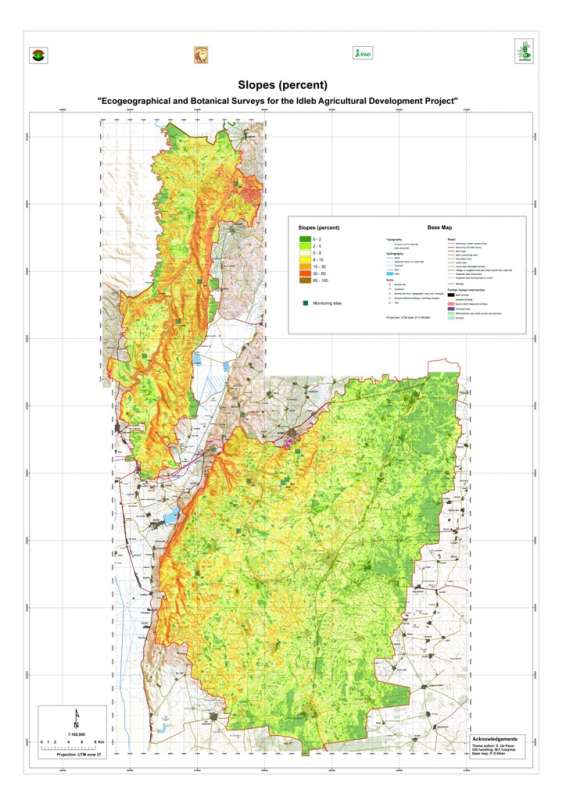
Metadataclose[x]
Jebel Zawia: Slopes
Characterisation of the agricultural environment in Jebel Zawia and in Jebel Wastani with a view to develop management plans for areas with valuable plant biodiversity (Idleb Rural Development Project)
Slopes in the Jebel Zawia area.
International Center for Agricultural Research in the Dry Areas (ICARDA)
2008
slope
Syria, Idleb, Zawia
36.381926
36.900061
35.901056
35.377164
D_WGS_1984
WGS_1984
6378137.000000
298.257224