


Geoinformatics Solutions for Integrated Agro-ecosystems Research
GIS Data
Maps in: CACILM

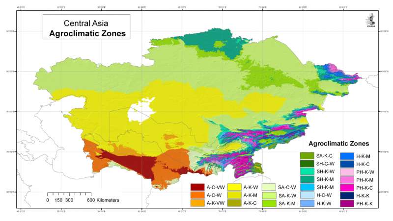
Central Asia: Agroclimatic Zones
Agroclimatic Zones for Central Asia at 30 arc-second ( about 1 km) resolution
Metadataclose[x]
Central Asia: Agroclimatic Zones
To provide a synthesis of location-specific climatic conditions using a climatic classification system
Agroclimatic Zones for Central Asia at 30 arc-second ( about 1 km) resolution
International Center for Agricultural Research in the Dry Areas (ICARDA)
2008
climate, climate classification, arid zones, UNESCO
Central Asia, Tajikistan, Turkmenistan, Kazakhstan, Uzbekistan, Kyrgyzstan
46.491856
87.315223
55.431949
35.141094
D_WGS_1984
WGS_1984
6378137.000000
298.257224

Central Asia: Annual Aridity Index
Annual Aridity Index for Central Asia at 30 arc-second ( about 1 km) resolution
Metadataclose[x]
Central Asia: Annual Aridity Index
To provide a measure of aridity for specific locations using an index
Annual Aridity Index for Central Asia at 30 arc-second ( about 1 km) resolution
International Center for Agricultural Research in the Dry Areas (ICARDA)
2008
climate, aridity index, arid zones, UNESCO
Central Asia, Tajikistan, Turkmenistan, Kazakhstan, Uzbekistan, Kyrgyzstan
46.491856
87.308524
55.424429
35.141094
D_WGS_1984
WGS_1984
6378137.000000
298.257224

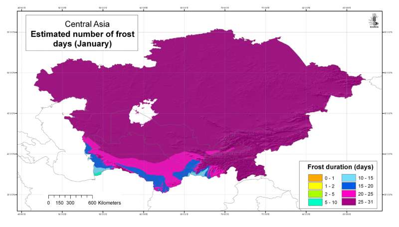
Estimated number of frost days: January
Estimated number of frost days in Central Asia at 30 arc-second ( about 1 km) resolution: January
Metadataclose[x]
Estimated number of frost days: January
Developed for geospatial applications that require location-specific climatic information in places where no nearby climatic station exists
Estimated number of frost days in Central Asia at 30 arc-second ( about 1 km) resolution: January
International Center for Agricultural Research in the Dry Areas (ICARDA)
2008
climate, temperature, frost
Central Asia, Tajikistan, Turkmenistan, Kazakhstan, Uzbekistan, Kyrgyzstan
46.491856
87.308524
55.424429
35.141094
D_WGS_1984
WGS_1984
6378137.000000
298.257224

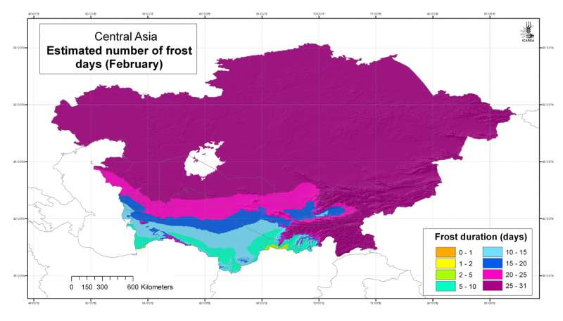
Estimated number of frost days: February
Estimated number of frost days in Central Asia at 30 arc-second ( about 1 km) resolution: February
Metadataclose[x]
Estimated number of frost days: February
Developed for geospatial applications that require location-specific climatic information in places where no nearby climatic station exists
Estimated number of frost days in Central Asia at 30 arc-second ( about 1 km) resolution: February
International Center for Agricultural Research in the Dry Areas (ICARDA)
2008
climate, temperature, frost
Central Asia, Tajikistan, Turkmenistan, Kazakhstan, Uzbekistan, Kyrgyzstan
46.491856
87.308524
55.424429
35.141094
D_WGS_1984
WGS_1984
6378137.000000
298.257224

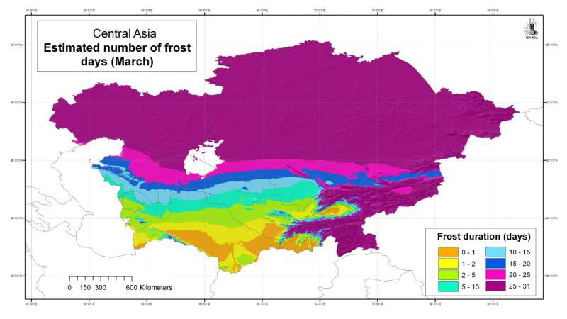
Estimated number of frost days: March
Estimated number of frost days in Central Asia at 30 arc-second ( about 1 km) resolution: March
Metadataclose[x]
Estimated number of frost days: March
Developed for geospatial applications that require location-specific climatic information in places where no nearby climatic station exists
Estimated number of frost days in Central Asia at 30 arc-second ( about 1 km) resolution: March
International Center for Agricultural Research in the Dry Areas (ICARDA)
2008
climate, temperature, frost
Central Asia, Tajikistan, Turkmenistan, Kazakhstan, Uzbekistan, Kyrgyzstan
46.491856
87.308524
55.424429
35.141094
D_WGS_1984
WGS_1984
6378137.000000
298.257224

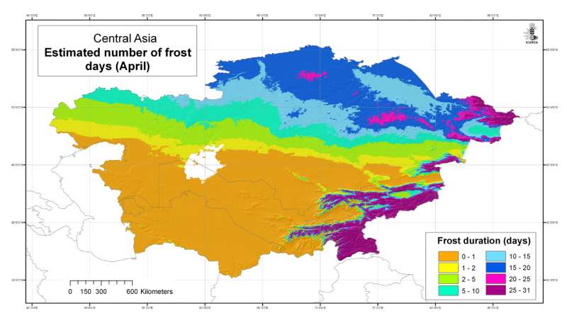
Estimated number of frost days: April
Estimated number of frost days in Central Asia at 30 arc-second ( about 1 km) resolution: April
Metadataclose[x]
Estimated number of frost days: April
Developed for geospatial applications that require location-specific climatic information in places where no nearby climatic station exists
Estimated number of frost days in Central Asia at 30 arc-second ( about 1 km) resolution: April
International Center for Agricultural Research in the Dry Areas (ICARDA)
2008
climate, temperature, frost
Central Asia, Tajikistan, Turkmenistan, Kazakhstan, Uzbekistan, Kyrgyzstan
46.491856
87.308524
55.424429
35.141094
D_WGS_1984
WGS_1984
6378137.000000
298.257224

Estimated number of frost days: May
Estimated number of frost days in Central Asia at 30 arc-second ( about 1 km) resolution: May
Metadataclose[x]
Estimated number of frost days: May
Developed for geospatial applications that require location-specific climatic information in places where no nearby climatic station exists
Estimated number of frost days in Central Asia at 30 arc-second ( about 1 km) resolution: May
International Center for Agricultural Research in the Dry Areas (ICARDA)
2008
climate, temperature, frost
Central Asia, Tajikistan, Turkmenistan, Kazakhstan, Uzbekistan, Kyrgyzstan
46.491856
87.308524
55.424429
35.141094
D_WGS_1984
WGS_1984
6378137.000000
298.257224

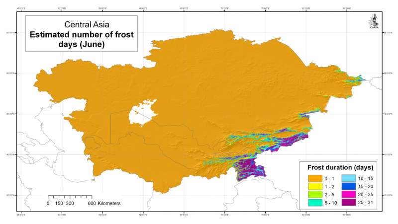
Estimated number of frost days: June
Estimated number of frost days in Central Asia at 30 arc-second ( about 1 km) resolution: June
Metadataclose[x]
Estimated number of frost days: June
Developed for geospatial applications that require location-specific climatic information in places where no nearby climatic station exists
Estimated number of frost days in Central Asia at 30 arc-second ( about 1 km) resolution: June
International Center for Agricultural Research in the Dry Areas (ICARDA)
2008
climate, temperature, frost
Central Asia, Tajikistan, Turkmenistan, Kazakhstan, Uzbekistan, Kyrgyzstan
46.491856
87.308524
55.424429
35.141094
D_WGS_1984
WGS_1984
6378137.000000
298.257224

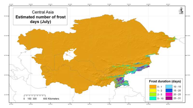
Estimated number of frost days: July
Estimated number of frost days in Central Asia at 30 arc-second ( about 1 km) resolution: July
Metadataclose[x]
Estimated number of frost days: July
Developed for geospatial applications that require location-specific climatic information in places where no nearby climatic station exists
Estimated number of frost days in Central Asia at 30 arc-second ( about 1 km) resolution: July
International Center for Agricultural Research in the Dry Areas (ICARDA)
2008
climate, temperature, frost
Central Asia, Tajikistan, Turkmenistan, Kazakhstan, Uzbekistan, Kyrgyzstan
46.491856
87.308524
55.424429
35.141094
D_WGS_1984
WGS_1984
6378137.000000
298.257224

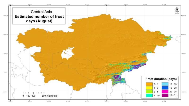
Estimated number of frost days: August
Estimated number of frost days in Central Asia at 30 arc-second ( about 1 km) resolution: August
Metadataclose[x]
Estimated number of frost days: August
Developed for geospatial applications that require location-specific climatic information in places where no nearby climatic station exists
Estimated number of frost days in Central Asia at 30 arc-second ( about 1 km) resolution: August
International Center for Agricultural Research in the Dry Areas (ICARDA)
2008
climate, temperature, frost
Central Asia, Tajikistan, Turkmenistan, Kazakhstan, Uzbekistan, Kyrgyzstan
46.491856
87.308524
55.424429
35.141094
D_WGS_1984
WGS_1984
6378137.000000
298.257224

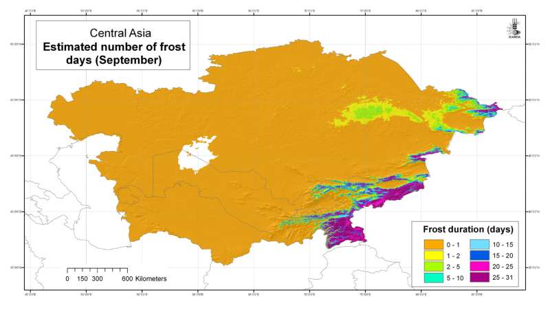
Estimated number of frost days: September
Estimated number of frost days in Central Asia at 30 arc-second ( about 1 km) resolution: September
Metadataclose[x]
Estimated number of frost days: September
Developed for geospatial applications that require location-specific climatic information in places where no nearby climatic station exists
Estimated number of frost days in Central Asia at 30 arc-second ( about 1 km) resolution: September
International Center for Agricultural Research in the Dry Areas (ICARDA)
2008
climate, temperature, frost
Central Asia, Tajikistan, Turkmenistan, Kazakhstan, Uzbekistan, Kyrgyzstan
46.491856
87.308524
55.424429
35.141094
D_WGS_1984
WGS_1984
6378137.000000
298.257224

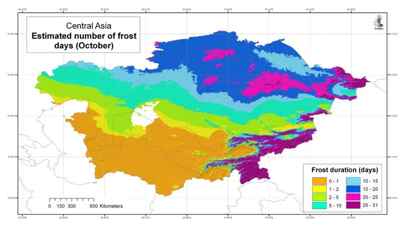
Estimated number of frost days: October
Estimated number of frost days in Central Asia at 30 arc-second ( about 1 km) resolution: October
Metadataclose[x]
Estimated number of frost days: October
Developed for geospatial applications that require location-specific climatic information in places where no nearby climatic station exists
Estimated number of frost days in Central Asia at 30 arc-second ( about 1 km) resolution: October
International Center for Agricultural Research in the Dry Areas (ICARDA)
2008
climate, temperature, frost
Central Asia, Tajikistan, Turkmenistan, Kazakhstan, Uzbekistan, Kyrgyzstan
46.491856
87.308524
55.424429
35.141094
D_WGS_1984
WGS_1984
6378137.000000
298.257224

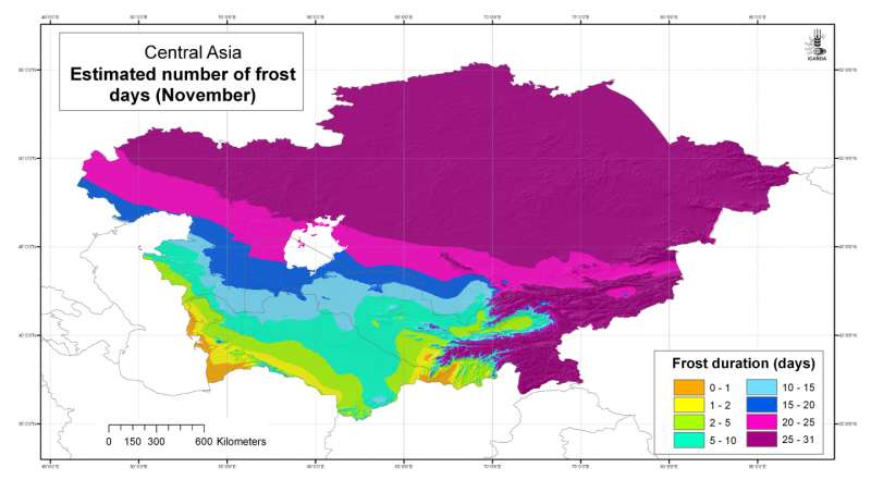
Estimated number of frost days: November
Estimated number of frost days in Central Asia at 30 arc-second ( about 1 km) resolution: November
Metadataclose[x]
Estimated number of frost days: November
Developed for geospatial applications that require location-specific climatic information in places where no nearby climatic station exists
Estimated number of frost days in Central Asia at 30 arc-second ( about 1 km) resolution: November
International Center for Agricultural Research in the Dry Areas (ICARDA)
2008
climate, temperature, frost
Central Asia, Tajikistan, Turkmenistan, Kazakhstan, Uzbekistan, Kyrgyzstan
46.491856
87.308524
55.424429
35.141094
D_WGS_1984
WGS_1984
6378137.000000
298.257224

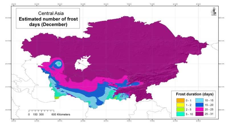
Estimated number of frost days: December
Estimated number of frost days in Central Asia at 30 arc-second ( about 1 km) resolution: December
Metadataclose[x]
Estimated number of frost days: December
Developed for geospatial applications that require location-specific climatic information in places where no nearby climatic station exists
Estimated number of frost days in Central Asia at 30 arc-second ( about 1 km) resolution: December
International Center for Agricultural Research in the Dry Areas (ICARDA)
2008
climate, temperature, frost
Central Asia, Tajikistan, Turkmenistan, Kazakhstan, Uzbekistan, Kyrgyzstan
46.491856
87.308524
55.424429
35.141094
D_WGS_1984
WGS_1984
6378137.000000
298.257224

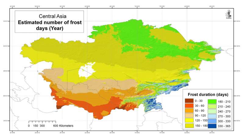
Estimated number of frost days: Year
Estimated number of frost days in Central Asia at 30 arc-second ( about 1 km) resolution: Year
Metadataclose[x]
Estimated number of frost days: Year
Developed for geospatial applications that require location-specific climatic information in places where no nearby climatic station exists
Estimated number of frost days in Central Asia at 30 arc-second ( about 1 km) resolution: Year
International Center for Agricultural Research in the Dry Areas (ICARDA)
2008
climate, temperature, frost
Central Asia, Tajikistan, Turkmenistan, Kazakhstan, Uzbekistan, Kyrgyzstan
46.491856
87.308524
55.424429
35.141094
D_WGS_1984
WGS_1984
6378137.000000
298.257224

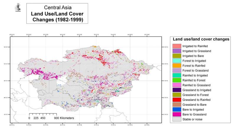
Central Asia: land use/land cover changes 1982-1999
Land use/land cover change classes for Central Asia at 4 arc-minute ( about 8 km) resolution
Metadataclose[x]
Central Asia: land use/land cover changes 1982-1999
To map areas of land use/land cover change and stability in the period 1982-1999
Land use/land cover change classes for Central Asia at 4 arc-minute ( about 8 km) resolution
International Center for Agricultural Research in the Dry Areas (ICARDA)
2008
land use, land cover, AVHRR, remote sensing, land degradation
Central Asia, Tajikistan, Turkmenistan, Kazakhstan, Uzbekistan, Kyrgyzstan
46.491856
87.292060
55.407862
35.141094
D_WGS_1984
WGS_1984
6378137.000000
298.257224
")
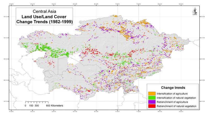
Central Asia: land use/land cover change trends (1982-1999)
Land use/land cover change trends for Central Asia at 4 arc-minute ( about 8 km) resolution
Metadataclose[x]
Central Asia: land use/land cover change trends (1982-1999)
To map areas of land use/land cover change and stability in the period 1982-1999
Land use/land cover change trends for Central Asia at 4 arc-minute ( about 8 km) resolution
International Center for Agricultural Research in the Dry Areas (ICARDA)
2008
land use change, land cover change, AVHRR, remote sensing, land degradation
Central Asia, Tajikistan, Turkmenistan, Kazakhstan, Uzbekistan, Kyrgyzstan
46.491856
87.292060
55.407862
35.141094
D_WGS_1984
WGS_1984
6378137.000000
298.257224

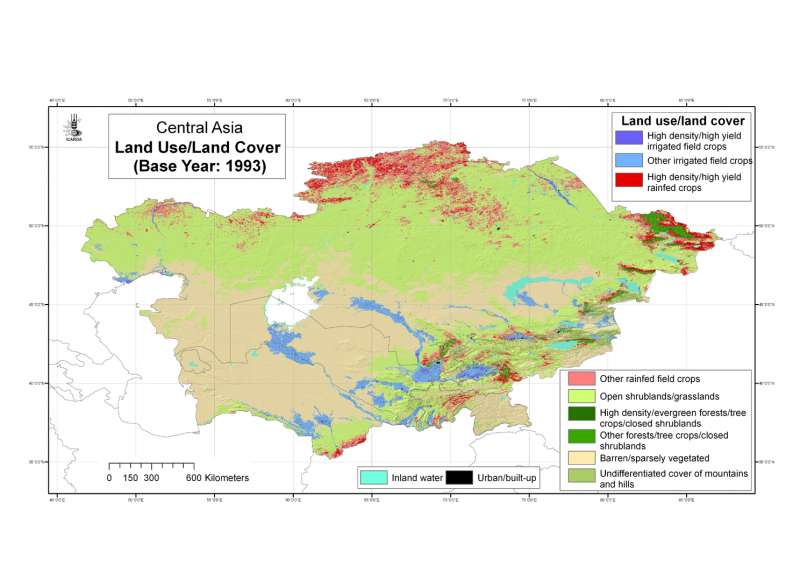
Central Asia: land use/land cover base year 1993
Land use/land cover classes for Central Asia at 30 arc-second ( about 1 km) resolution, base year 1993
Metadataclose[x]
Central Asia: land use/land cover base year 1993
To map land use/land cover using a simple but reliable classification system
Land use/land cover classes for Central Asia at 30 arc-second ( about 1 km) resolution, base year 1993
International Center for Agricultural Research in the Dry Areas (ICARDA)
2008
land use, land cover, AVHRR, remote sensing
Central Asia, Tajikistan, Turkmenistan, Kazakhstan, Uzbekistan, Kyrgyzstan
46.491856
87.308524
55.424429
35.141094
D_WGS_1984
WGS_1984
6378137.000000
298.257224

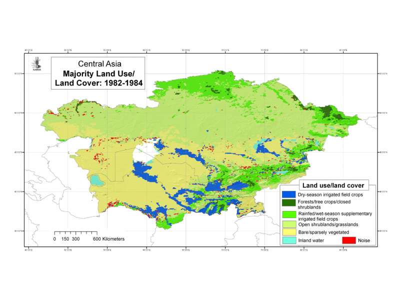
Central Asia: Majority land use/land cover during the period 1982-84
Majority land use/land cover in Central Asia during the period 1982-84 at 4 arc-minute ( about 8 km) resolution.
Metadataclose[x]
Central Asia: Majority land use/land cover during the period 1982-84
To map areas of land use/land cover change and stability in the period 1982-1999
Majority land use/land cover in Central Asia during the period 1982-84 at 4 arc-minute ( about 8 km) resolution.
International Center for Agricultural Research in the Dry Areas (ICARDA)
2008
land use, land cover, AVHRR, remote sensing, land degradation
Central Asia, Tajikistan, Turkmenistan, Kazakhstan, Uzbekistan, Kyrgyzstan
46.491856
87.292060
55.407862
35.141094
D_WGS_1984
WGS_1984
6378137.000000
298.257224

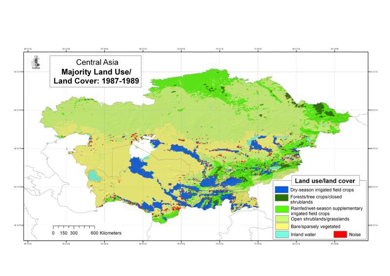
Central Asia: Majority land use/land cover during the period 1987-89
Majority land use/land cover in Central Asia during the period 1987-89 at 4 arc-minute ( about 8 km) resolution.
Metadataclose[x]
Central Asia: Majority land use/land cover during the period 1987-89
To map areas of land use/land cover change and stability in the period 1982-1999
Majority land use/land cover in Central Asia during the period 1987-89 at 4 arc-minute ( about 8 km) resolution.
International Center for Agricultural Research in the Dry Areas (ICARDA)
2008
land use, land cover, AVHRR, remote sensing, land degradation
Central Asia, Tajikistan, Turkmenistan, Kazakhstan, Uzbekistan, Kyrgyzstan
46.491856
87.292060
55.407862
35.141094
D_WGS_1984
WGS_1984
6378137.000000
298.257224

Central Asia: Majority land use/land cover during the period 1992-94
Majority land use/land cover in Central Asia during the period 1992-94 at 4 arc-minute ( about 8 km) resolution.
Metadataclose[x]
Central Asia: Majority land use/land cover during the period 1992-94
To map areas of land use/land cover change and stability in the period 1982-1999
Majority land use/land cover in Central Asia during the period 1992-94 at 4 arc-minute ( about 8 km) resolution.
International Center for Agricultural Research in the Dry Areas (ICARDA)
2008
land use, land cover, AVHRR, remote sensing, land degradation
Central Asia, Tajikistan, Turkmenistan, Kazakhstan, Uzbekistan, Kyrgyzstan
46.491856
87.292060
55.407862
35.141094
D_WGS_1984
WGS_1984
6378137.000000
298.257224

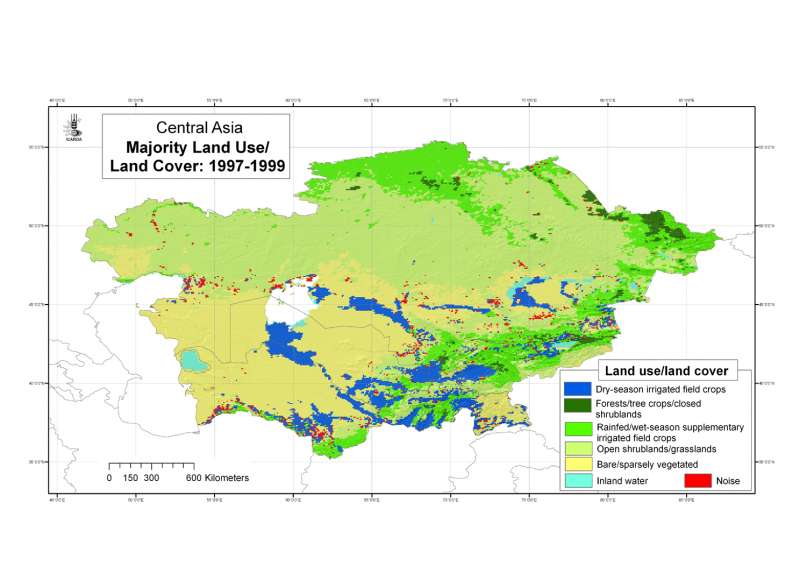
Central Asia: Majority land use/land cover during the period 1997-99
Majority land use/land cover in Central Asia during the period 1997-99 at 4 arc-minute ( about 8 km) resolution.
Metadataclose[x]
Central Asia: Majority land use/land cover during the period 1997-99
To map areas of land use/land cover change and stability in the period 1982-1999
Majority land use/land cover in Central Asia during the period 1997-99 at 4 arc-minute ( about 8 km) resolution.
International Center for Agricultural Research in the Dry Areas (ICARDA)
2008
land use, land cover, AVHRR, remote sensing, land degradation
Central Asia, Tajikistan, Turkmenistan, Kazakhstan, Uzbekistan, Kyrgyzstan
46.491856
87.292060
55.407862
35.141094
D_WGS_1984
WGS_1984
6378137.000000
298.257224
")
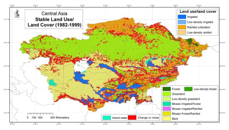
Central Asia: stable land use/land cover (1982-1999)
Stable land use/land cover classes for Central Asia during the period 1982-1999 at 4 arc-minute ( about 8 km) resolution
Metadataclose[x]
Central Asia: stable land use/land cover (1982-1999)
To map areas of land use/land cover change and stability in the period 1982-1999
Stable land use/land cover classes for Central Asia during the period 1982-1999 at 4 arc-minute ( about 8 km) resolution
International Center for Agricultural Research in the Dry Areas (ICARDA)
2008
land use, land cover, AVHRR, remote sensing, land degradation
Central Asia, Tajikistan, Turkmenistan, Kazakhstan, Uzbekistan, Kyrgyzstan
46.491856
87.306890
55.431949
35.141094
D_WGS_1984
WGS_1984
6378137.000000
298.257224
")
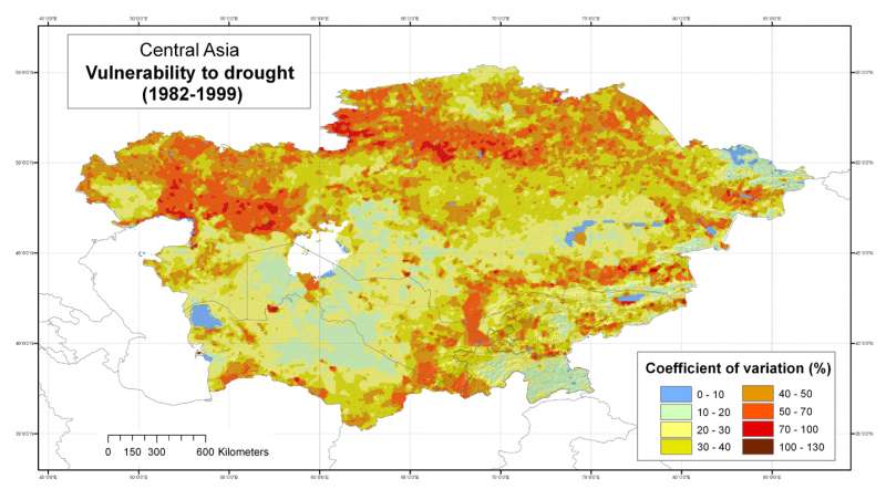
Central Asia: vulnerability to climatic variability and drought (1982-99)
Fluctuations in biomass in Central Asia after actual land use/land cover change in the period 1982-99 has been filtered out, at 4 arc-minute ( about 8 km) resolution
Metadataclose[x]
Central Asia: vulnerability to climatic variability and drought (1982-99)
To map areas most vulnerable to climatic variability and drought in the period 1982-1999
Fluctuations in biomass in Central Asia after actual land use/land cover change in the period 1982-99 has been filtered out, at 4 arc-minute ( about 8 km) resolution
International Center for Agricultural Research in the Dry Areas (ICARDA)
2008
land use change, land cover change, AVHRR, remote sensing, land degradation, climatic variability, drought
Central Asia, Tajikistan, Turkmenistan, Kazakhstan, Uzbekistan, Kyrgyzstan
46.491856
87.344014
55.400566
35.141094
D_WGS_1984
WGS_1984
6378137.000000
298.257224
 January")
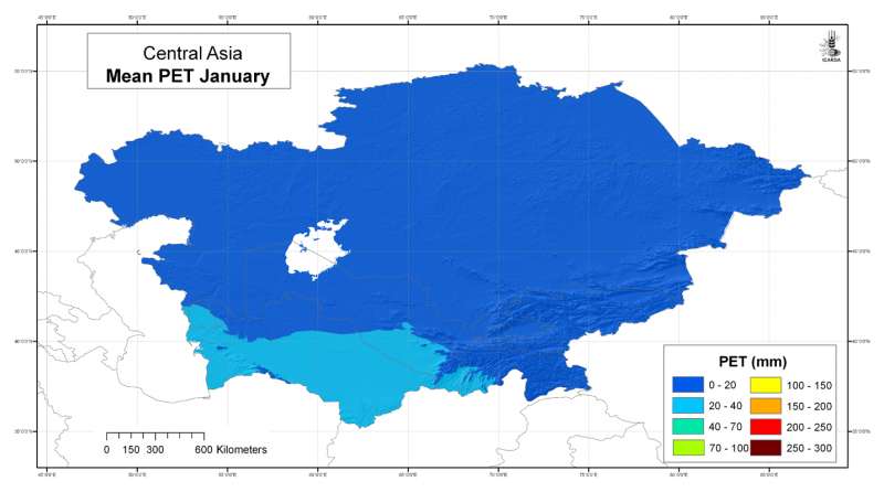
Central Asia: mean potential evapotranspiration (Penman-Monteith) January
Mean monthly potential evapotranspiration (PET) grid for Central Asia at 30 arc-second ( about 1 km) resolution: January
Metadataclose[x]
Central Asia: mean potential evapotranspiration (Penman-Monteith) January
Developed for geospatial applications that require location-specific information on atmospheric water requirements in places where no nearby climatic station exists
Mean monthly potential evapotranspiration (PET) grid for Central Asia at 30 arc-second ( about 1 km) resolution: January
International Center for Agricultural Research in the Dry Areas (ICARDA)
2008
climate, potential evapotranspiration, reference evapotranspiration, Penman-Monteith, Hargreaves, temperature
Central Asia, Tajikistan, Turkmenistan, Kazakhstan, Uzbekistan, Kyrgyzstan
46.491856
87.308524
55.424429
35.141094
D_WGS_1984
WGS_1984
6378137.000000
298.257224
 February")
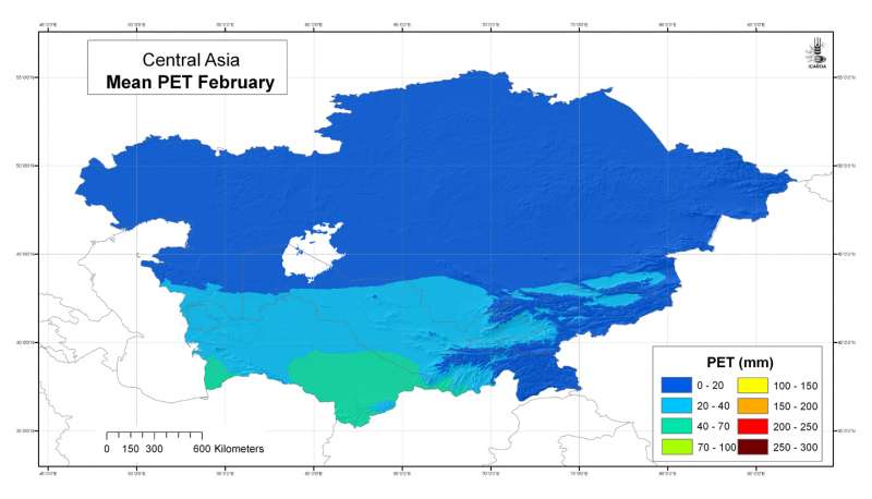
Central Asia: mean potential evapotranspiration (Penman-Monteith) February
Mean monthly potential evapotranspiration (PET) grid for Central Asia at 30 arc-second ( about 1 km) resolution: February
Metadataclose[x]
Central Asia: mean potential evapotranspiration (Penman-Monteith) February
Developed for geospatial applications that require location-specific information on atmospheric water requirements in places where no nearby climatic station exists
Mean monthly potential evapotranspiration (PET) grid for Central Asia at 30 arc-second ( about 1 km) resolution: February
International Center for Agricultural Research in the Dry Areas (ICARDA)
2008
climate, potential evapotranspiration, reference evapotranspiration, Penman-Monteith, Hargreaves, temperature
Central Asia, Tajikistan, Turkmenistan, Kazakhstan, Uzbekistan, Kyrgyzstan
46.491856
87.308524
55.424429
35.141094
D_WGS_1984
WGS_1984
6378137.000000
298.257224
 March")
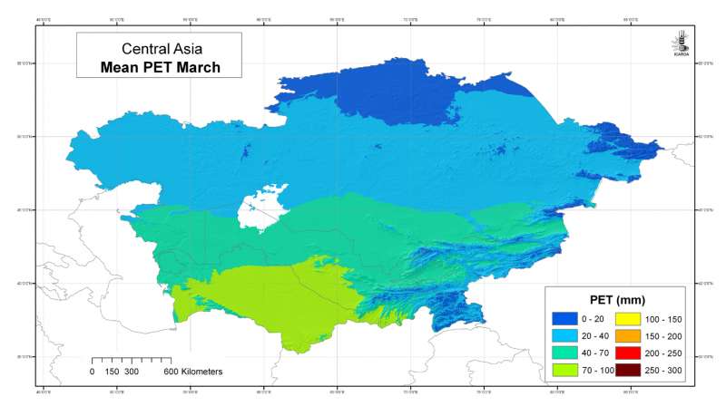
Central Asia: mean potential evapotranspiration (Penman-Monteith) March
Mean monthly potential evapotranspiration (PET) grid for Central Asia at 30 arc-second ( about 1 km) resolution: March
Metadataclose[x]
Central Asia: mean potential evapotranspiration (Penman-Monteith) March
Developed for geospatial applications that require location-specific information on atmospheric water requirements in places where no nearby climatic station exists
Mean monthly potential evapotranspiration (PET) grid for Central Asia at 30 arc-second ( about 1 km) resolution: March
International Center for Agricultural Research in the Dry Areas (ICARDA)
2008
climate, potential evapotranspiration, reference evapotranspiration, Penman-Monteith, Hargreaves, temperature
Central Asia, Tajikistan, Turkmenistan, Kazakhstan, Uzbekistan, Kyrgyzstan
46.491856
87.308524
55.424429
35.141094
D_WGS_1984
WGS_1984
6378137.000000
298.257224
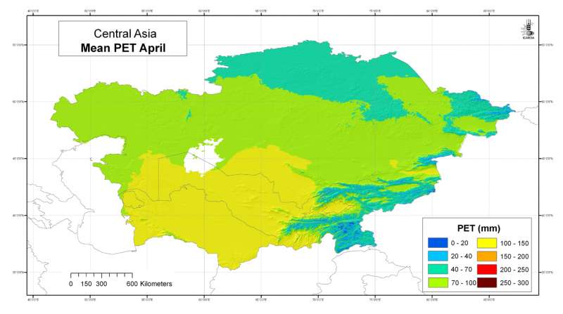
 April")
Central Asia: mean potential evapotranspiration (Penman-Monteith) April
Mean monthly potential evapotranspiration (PET) grid for Central Asia at 30 arc-second ( about 1 km) resolution: April
Metadataclose[x]
Central Asia: mean potential evapotranspiration (Penman-Monteith) April
Developed for geospatial applications that require location-specific information on atmospheric water requirements in places where no nearby climatic station exists
Mean monthly potential evapotranspiration (PET) grid for Central Asia at 30 arc-second ( about 1 km) resolution: April
International Center for Agricultural Research in the Dry Areas (ICARDA)
2008
climate, potential evapotranspiration, reference evapotranspiration, Penman-Monteith, Hargreaves, temperature
Central Asia, Tajikistan, Turkmenistan, Kazakhstan, Uzbekistan, Kyrgyzstan
46.491856
87.308524
55.424429
35.141094
D_WGS_1984
WGS_1984
6378137.000000
298.257224
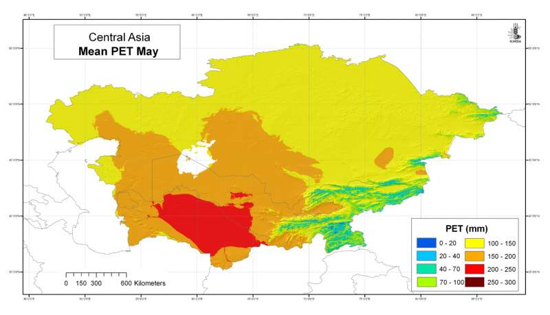
 May")
Central Asia: mean potential evapotranspiration (Penman-Monteith) May
Mean monthly potential evapotranspiration (PET) grid for Central Asia at 30 arc-second ( about 1 km) resolution: May
Metadataclose[x]
Central Asia: mean potential evapotranspiration (Penman-Monteith) May
Developed for geospatial applications that require location-specific information on atmospheric water requirements in places where no nearby climatic station exists
Mean monthly potential evapotranspiration (PET) grid for Central Asia at 30 arc-second ( about 1 km) resolution: May
International Center for Agricultural Research in the Dry Areas (ICARDA)
2008
climate, potential evapotranspiration, reference evapotranspiration, Penman-Monteith, Hargreaves, temperature
Central Asia, Tajikistan, Turkmenistan, Kazakhstan, Uzbekistan, Kyrgyzstan
46.491856
87.308524
55.424429
35.141094
D_WGS_1984
WGS_1984
6378137.000000
298.257224
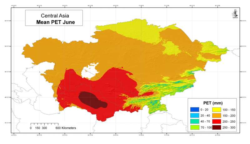
 June")
Central Asia: mean potential evapotranspiration (Penman-Monteith) June
Mean monthly potential evapotranspiration (PET) grid for Central Asia at 30 arc-second ( about 1 km) resolution: June
Metadataclose[x]
Central Asia: mean potential evapotranspiration (Penman-Monteith) June
Developed for geospatial applications that require location-specific information on atmospheric water requirements in places where no nearby climatic station exists
Mean monthly potential evapotranspiration (PET) grid for Central Asia at 30 arc-second ( about 1 km) resolution: June
International Center for Agricultural Research in the Dry Areas (ICARDA)
2008
climate, potential evapotranspiration, reference evapotranspiration, Penman-Monteith, Hargreaves, temperature
Central Asia, Tajikistan, Turkmenistan, Kazakhstan, Uzbekistan, Kyrgyzstan
46.491856
87.308524
55.424429
35.141094
D_WGS_1984
WGS_1984
6378137.000000
298.257224
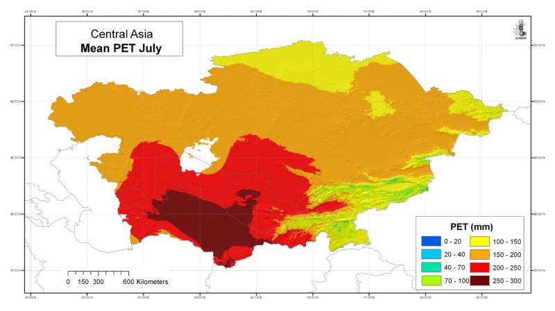
 July")
Central Asia: mean potential evapotranspiration (Penman-Monteith) July
Mean monthly potential evapotranspiration (PET) grid for Central Asia at 30 arc-second ( about 1 km) resolution: July
Metadataclose[x]
Central Asia: mean potential evapotranspiration (Penman-Monteith) July
Developed for geospatial applications that require location-specific information on atmospheric water requirements in places where no nearby climatic station exists
Mean monthly potential evapotranspiration (PET) grid for Central Asia at 30 arc-second ( about 1 km) resolution: July
International Center for Agricultural Research in the Dry Areas (ICARDA)
2008
climate, potential evapotranspiration, reference evapotranspiration, Penman-Monteith, Hargreaves, temperature
Central Asia, Tajikistan, Turkmenistan, Kazakhstan, Uzbekistan, Kyrgyzstan
46.491856
87.308524
55.424429
35.141094
D_WGS_1984
WGS_1984
6378137.000000
298.257224
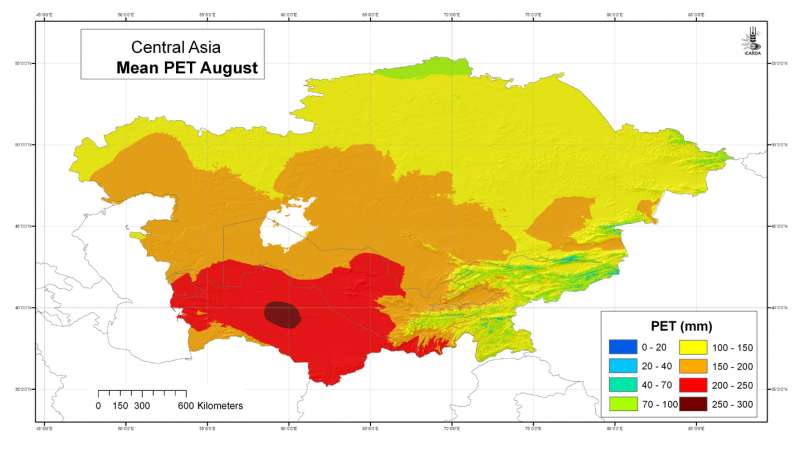
 August")
Central Asia: mean potential evapotranspiration (Penman-Monteith) August
Mean monthly potential evapotranspiration (PET) grid for Central Asia at 30 arc-second ( about 1 km) resolution: August
Metadataclose[x]
Central Asia: mean potential evapotranspiration (Penman-Monteith) August
Developed for geospatial applications that require location-specific information on atmospheric water requirements in places where no nearby climatic station exists
Mean monthly potential evapotranspiration (PET) grid for Central Asia at 30 arc-second ( about 1 km) resolution: August
International Center for Agricultural Research in the Dry Areas (ICARDA)
2008
climate, potential evapotranspiration, reference evapotranspiration, Penman-Monteith, Hargreaves, temperature
Central Asia, Tajikistan, Turkmenistan, Kazakhstan, Uzbekistan, Kyrgyzstan
46.491856
87.308524
55.424429
35.141094
D_WGS_1984
WGS_1984
6378137.000000
298.257224
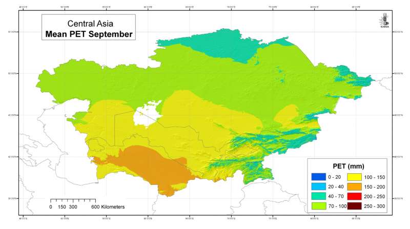
 September")
Central Asia: mean potential evapotranspiration (Penman-Monteith) September
Mean monthly potential evapotranspiration (PET) grid for Central Asia at 30 arc-second ( about 1 km) resolution: September
Metadataclose[x]
Central Asia: mean potential evapotranspiration (Penman-Monteith) September
Developed for geospatial applications that require location-specific information on atmospheric water requirements in places where no nearby climatic station exists
Mean monthly potential evapotranspiration (PET) grid for Central Asia at 30 arc-second ( about 1 km) resolution: September
International Center for Agricultural Research in the Dry Areas (ICARDA)
2008
climate, potential evapotranspiration, reference evapotranspiration, Penman-Monteith, Hargreaves, temperature
Central Asia, Tajikistan, Turkmenistan, Kazakhstan, Uzbekistan, Kyrgyzstan
46.491856
87.308524
55.424429
35.141094
D_WGS_1984
WGS_1984
6378137.000000
298.257224
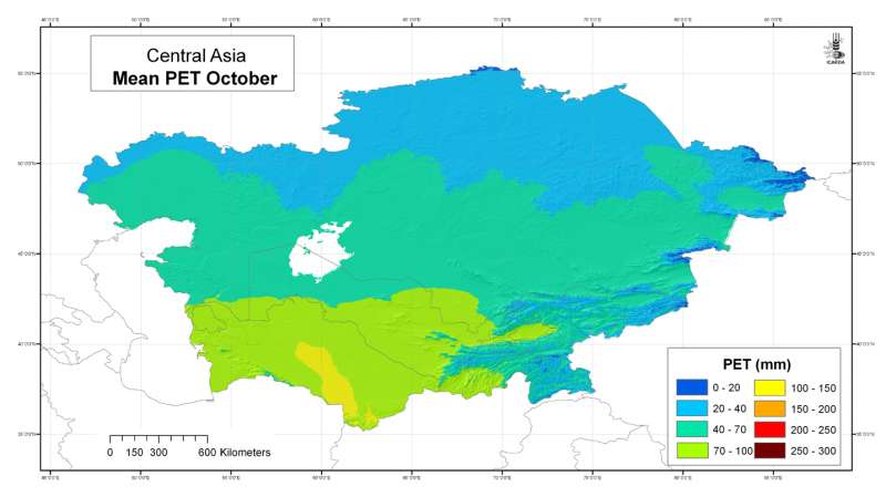
 October")
Central Asia: mean potential evapotranspiration (Penman-Monteith) October
Mean monthly potential evapotranspiration (PET) grid for Central Asia at 30 arc-second ( about 1 km) resolution: October
Metadataclose[x]
Central Asia: mean potential evapotranspiration (Penman-Monteith) October
Developed for geospatial applications that require location-specific information on atmospheric water requirements in places where no nearby climatic station exists
Mean monthly potential evapotranspiration (PET) grid for Central Asia at 30 arc-second ( about 1 km) resolution: October
International Center for Agricultural Research in the Dry Areas (ICARDA)
2008
climate, potential evapotranspiration, reference evapotranspiration, Penman-Monteith, Hargreaves, temperature
Central Asia, Tajikistan, Turkmenistan, Kazakhstan, Uzbekistan, Kyrgyzstan
46.491856
87.308524
55.424429
35.141094
D_WGS_1984
WGS_1984
6378137.000000
298.257224
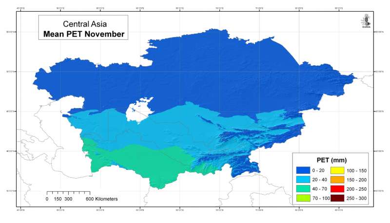
 November")
Central Asia: mean potential evapotranspiration (Penman-Monteith) November
Mean monthly potential evapotranspiration (PET) grid for Central Asia at 30 arc-second ( about 1 km) resolution: November
Metadataclose[x]
Central Asia: mean potential evapotranspiration (Penman-Monteith) November
Developed for geospatial applications that require location-specific information on atmospheric water requirements in places where no nearby climatic station exists
Mean monthly potential evapotranspiration (PET) grid for Central Asia at 30 arc-second ( about 1 km) resolution: November
International Center for Agricultural Research in the Dry Areas (ICARDA)
2008
climate, potential evapotranspiration, reference evapotranspiration, Penman-Monteith, Hargreaves, temperature
Central Asia, Tajikistan, Turkmenistan, Kazakhstan, Uzbekistan, Kyrgyzstan
46.491856
87.308524
55.424429
35.141094
D_WGS_1984
WGS_1984
6378137.000000
298.257224
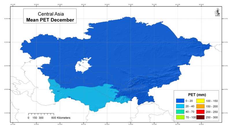
 December")
Central Asia: mean potential evapotranspiration (Penman-Monteith) December
Mean monthly potential evapotranspiration (PET) grid for Central Asia at 30 arc-second ( about 1 km) resolution: December
Metadataclose[x]
Central Asia: mean potential evapotranspiration (Penman-Monteith) December
Developed for geospatial applications that require location-specific information on atmospheric water requirements in places where no nearby climatic station exists
Mean monthly potential evapotranspiration (PET) grid for Central Asia at 30 arc-second ( about 1 km) resolution: December
International Center for Agricultural Research in the Dry Areas (ICARDA)
2008
climate, potential evapotranspiration, reference evapotranspiration, Penman-Monteith, Hargreaves, temperature
Central Asia, Tajikistan, Turkmenistan, Kazakhstan, Uzbekistan, Kyrgyzstan
46.491856
87.308524
55.424429
35.141094
D_WGS_1984
WGS_1984
6378137.000000
298.257224
")
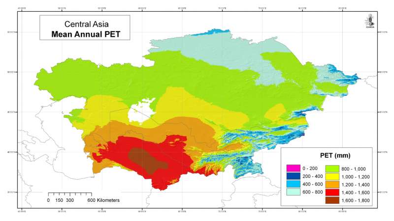
Central Asia: mean annual potential evapotranspiration (Penman-Monteith)
Mean annual potential evapotranspiration (PET) grid for Central Asia at 30 arc-second ( about 1 km) resolution
Metadataclose[x]
Central Asia: mean annual potential evapotranspiration (Penman-Monteith)
Developed for geospatial applications that require location-specific information on atmospheric water requirements in places where no nearby climatic station exists
Mean annual potential evapotranspiration (PET) grid for Central Asia at 30 arc-second ( about 1 km) resolution
International Center for Agricultural Research in the Dry Areas (ICARDA)
2008
climate, potential evapotranspiration, reference evapotranspiration, Penman-Monteith, Hargreaves, temperature
Central Asia, Tajikistan, Turkmenistan, Kazakhstan, Uzbekistan, Kyrgyzstan
46.491856
87.308524
55.424429
35.141094
D_WGS_1984
WGS_1984
6378137.000000
298.257224

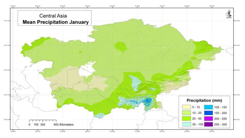
Central Asia: mean precipitation January
Mean monthly precipitation grid for Central Asia at 30 arc-second ( about 1 km) resolution: January
Metadataclose[x]
Central Asia: mean precipitation January
Developed for geospatial applications that require location-specific climatic information in places where no nearby climatic station exists
Mean monthly precipitation grid for Central Asia at 30 arc-second ( about 1 km) resolution: January
International Center for Agricultural Research in the Dry Areas (ICARDA)
2008
climate, precipitation
Central Asia, Tajikistan, Turkmenistan, Kazakhstan, Uzbekistan, Kyrgyzstan
46.491856
87.308524
55.424429
35.141094
D_WGS_1984
WGS_1984
6378137.000000
298.257224

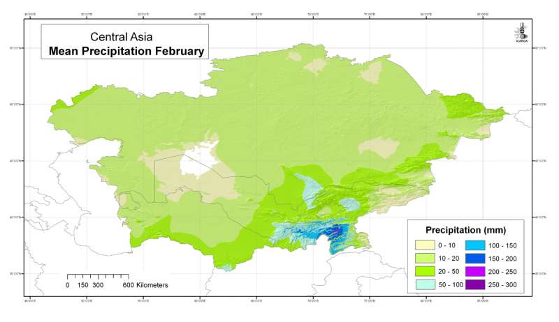
Central Asia: mean precipitation February
Mean monthly precipitation grid for Central Asia at 30 arc-second ( about 1 km) resolution: February
Metadataclose[x]
Central Asia: mean precipitation February
Developed for geospatial applications that require location-specific climatic information in places where no nearby climatic station exists
Mean monthly precipitation grid for Central Asia at 30 arc-second ( about 1 km) resolution: February
International Center for Agricultural Research in the Dry Areas (ICARDA)
2008
climate, precipitation
Central Asia, Tajikistan, Turkmenistan, Kazakhstan, Uzbekistan, Kyrgyzstan
46.491856
87.308524
55.424429
35.141094
D_WGS_1984
WGS_1984
6378137.000000
298.257224

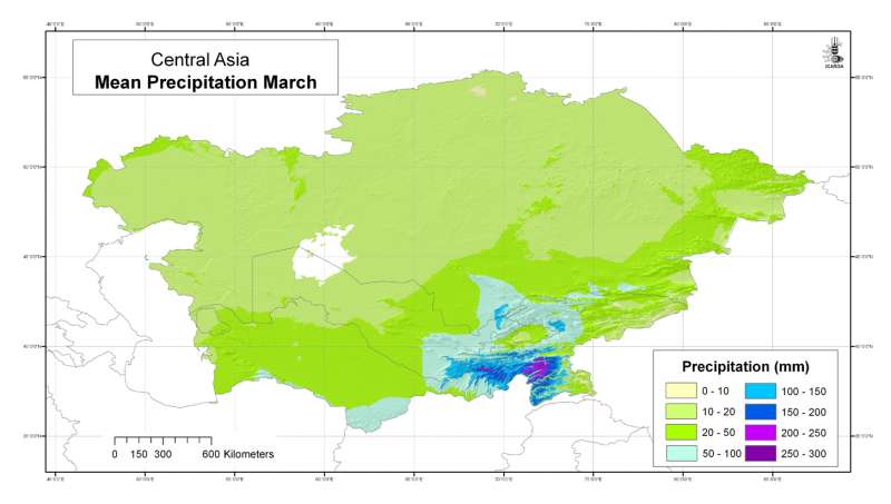
Central Asia: mean precipitation March
Mean monthly precipitation grid for Central Asia at 30 arc-second ( about 1 km) resolution: March
Metadataclose[x]
Central Asia: mean precipitation March
Developed for geospatial applications that require location-specific climatic information in places where no nearby climatic station exists
Mean monthly precipitation grid for Central Asia at 30 arc-second ( about 1 km) resolution: March
International Center for Agricultural Research in the Dry Areas (ICARDA)
2008
climate, precipitation
Central Asia, Tajikistan, Turkmenistan, Kazakhstan, Uzbekistan, Kyrgyzstan
46.491856
87.308524
55.424429
35.141094
D_WGS_1984
WGS_1984
6378137.000000
298.257224

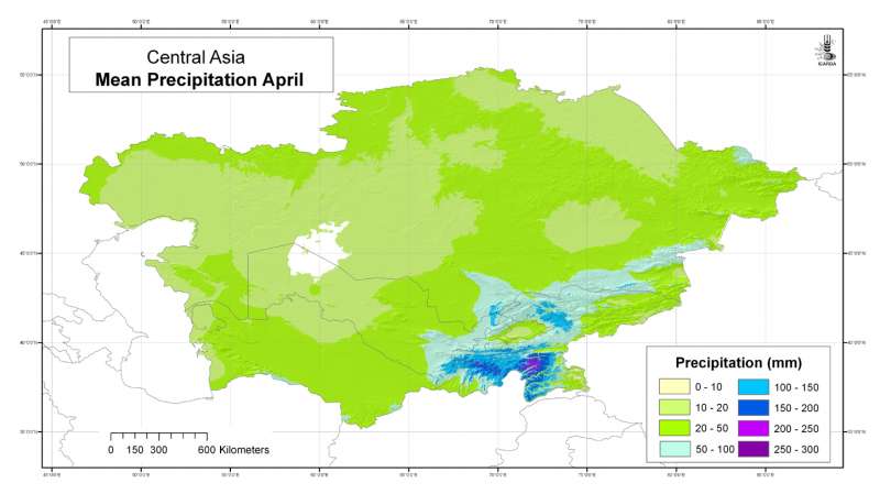
Central Asia: mean precipitation April
Mean monthly precipitation grid for Central Asia at 30 arc-second ( about 1 km) resolution: April
Metadataclose[x]
Central Asia: mean precipitation April
Developed for geospatial applications that require location-specific climatic information in places where no nearby climatic station exists
Mean monthly precipitation grid for Central Asia at 30 arc-second ( about 1 km) resolution: April
International Center for Agricultural Research in the Dry Areas (ICARDA)
2008
climate, precipitation
Central Asia, Tajikistan, Turkmenistan, Kazakhstan, Uzbekistan, Kyrgyzstan
46.491856
87.308524
55.424429
35.141094
D_WGS_1984
WGS_1984
6378137.000000
298.257224

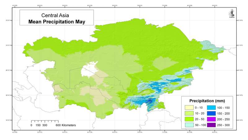
Central Asia: mean precipitation May
Mean monthly precipitation grid for Central Asia at 30 arc-second ( about 1 km) resolution: May
Metadataclose[x]
Central Asia: mean precipitation May
Developed for geospatial applications that require location-specific climatic information in places where no nearby climatic station exists
Mean monthly precipitation grid for Central Asia at 30 arc-second ( about 1 km) resolution: May
International Center for Agricultural Research in the Dry Areas (ICARDA)
2008
climate, precipitation
Central Asia, Tajikistan, Turkmenistan, Kazakhstan, Uzbekistan, Kyrgyzstan
46.491856
87.308524
55.424429
35.141094
D_WGS_1984
WGS_1984
6378137.000000
298.257224

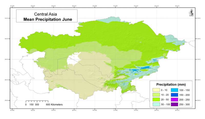
Central Asia: mean precipitation June
Mean monthly precipitation grid for Central Asia at 30 arc-second ( about 1 km) resolution: June
Metadataclose[x]
Central Asia: mean precipitation June
Developed for geospatial applications that require location-specific climatic information in places where no nearby climatic station exists
Mean monthly precipitation grid for Central Asia at 30 arc-second ( about 1 km) resolution: June
International Center for Agricultural Research in the Dry Areas (ICARDA)
2008
climate, precipitation
Central Asia, Tajikistan, Turkmenistan, Kazakhstan, Uzbekistan, Kyrgyzstan
46.491856
87.308524
55.424429
35.141094
D_WGS_1984
WGS_1984
6378137.000000
298.257224

Central Asia: mean precipitation July
Mean monthly precipitation grid for Central Asia at 30 arc-second ( about 1 km) resolution: July
Metadataclose[x]
Central Asia: mean precipitation July
Developed for geospatial applications that require location-specific climatic information in places where no nearby climatic station exists
Mean monthly precipitation grid for Central Asia at 30 arc-second ( about 1 km) resolution: July
International Center for Agricultural Research in the Dry Areas (ICARDA)
2008
climate, precipitation
Central Asia, Tajikistan, Turkmenistan, Kazakhstan, Uzbekistan, Kyrgyzstan
46.491856
87.308524
55.424429
35.141094
D_WGS_1984
WGS_1984
6378137.000000
298.257224

Central Asia: mean precipitation August
Mean monthly precipitation grid for Central Asia at 30 arc-second ( about 1 km) resolution: August
Metadataclose[x]
Central Asia: mean precipitation August
Developed for geospatial applications that require location-specific climatic information in places where no nearby climatic station exists
Mean monthly precipitation grid for Central Asia at 30 arc-second ( about 1 km) resolution: August
International Center for Agricultural Research in the Dry Areas (ICARDA)
2008
climate, precipitation
Central Asia, Tajikistan, Turkmenistan, Kazakhstan, Uzbekistan, Kyrgyzstan
46.491856
87.308524
55.424429
35.141094
D_WGS_1984
WGS_1984
6378137.000000
298.257224

Central Asia: mean precipitation September
Mean monthly precipitation grid for Central Asia at 30 arc-second ( about 1 km) resolution: September
Metadataclose[x]
Central Asia: mean precipitation September
Developed for geospatial applications that require location-specific climatic information in places where no nearby climatic station exists
Mean monthly precipitation grid for Central Asia at 30 arc-second ( about 1 km) resolution: September
International Center for Agricultural Research in the Dry Areas (ICARDA)
2008
climate, precipitation
Central Asia, Tajikistan, Turkmenistan, Kazakhstan, Uzbekistan, Kyrgyzstan
46.491856
87.308524
55.424429
35.141094
D_WGS_1984
WGS_1984
6378137.000000
298.257224

Central Asia: mean precipitation October
Mean monthly precipitation grid for Central Asia at 30 arc-second ( about 1 km) resolution: October
Metadataclose[x]
Central Asia: mean precipitation October
Developed for geospatial applications that require location-specific climatic information in places where no nearby climatic station exists
Mean monthly precipitation grid for Central Asia at 30 arc-second ( about 1 km) resolution: October
International Center for Agricultural Research in the Dry Areas (ICARDA)
2008
climate, precipitation
Central Asia, Tajikistan, Turkmenistan, Kazakhstan, Uzbekistan, Kyrgyzstan
46.491856
87.308524
55.424429
35.141094
D_WGS_1984
WGS_1984
6378137.000000
298.257224

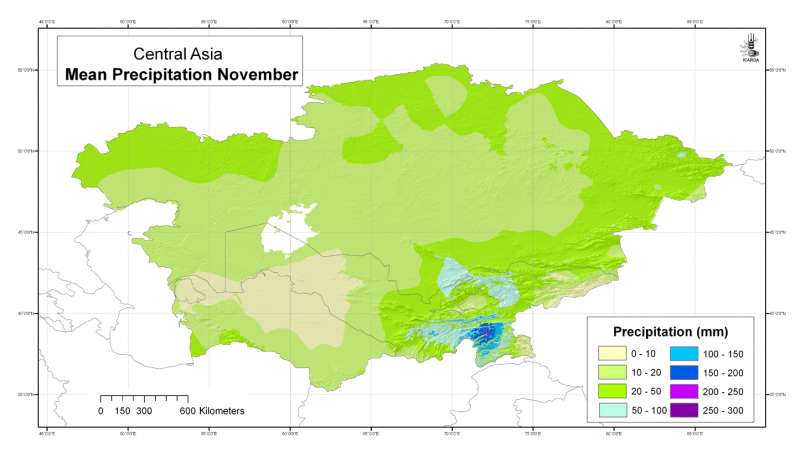
Central Asia: mean precipitation November
Mean monthly precipitation grid for Central Asia at 30 arc-second ( about 1 km) resolution: November
Metadataclose[x]
Central Asia: mean precipitation November
Developed for geospatial applications that require location-specific climatic information in places where no nearby climatic station exists
Mean monthly precipitation grid for Central Asia at 30 arc-second ( about 1 km) resolution: November
International Center for Agricultural Research in the Dry Areas (ICARDA)
2008
climate, precipitation
Central Asia, Tajikistan, Turkmenistan, Kazakhstan, Uzbekistan, Kyrgyzstan
46.491856
87.308524
55.424429
35.141094
D_WGS_1984
WGS_1984
6378137.000000
298.257224

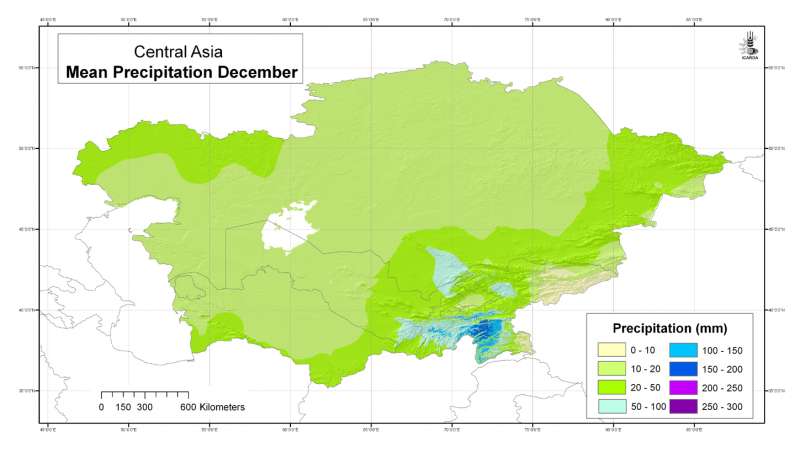
Central Asia: mean precipitation December
Mean monthly precipitation grid for Central Asia at 30 arc-second ( about 1 km) resolution: December
Metadataclose[x]
Central Asia: mean precipitation December
Developed for geospatial applications that require location-specific climatic information in places where no nearby climatic station exists
Mean monthly precipitation grid for Central Asia at 30 arc-second ( about 1 km) resolution: December
International Center for Agricultural Research in the Dry Areas (ICARDA)
2008
climate, precipitation
Central Asia, Tajikistan, Turkmenistan, Kazakhstan, Uzbekistan, Kyrgyzstan
46.491856
87.308524
55.424429
35.141094
D_WGS_1984
WGS_1984
6378137.000000
298.257224

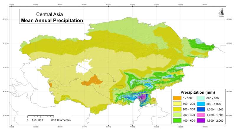
Central Asia: mean annual precipitation
Mean annual precipitation grid for Central Asia at 30 arc-second ( about 1 km) resolution
Metadataclose[x]
Central Asia: mean annual precipitation
Developed for geospatial applications that require location-specific climatic information in places where no nearby climatic station exists
Mean annual precipitation grid for Central Asia at 30 arc-second ( about 1 km) resolution
International Center for Agricultural Research in the Dry Areas (ICARDA)
2008
climate, precipitation
Central Asia, Tajikistan, Turkmenistan, Kazakhstan, Uzbekistan, Kyrgyzstan
46.491856
87.308522
55.432761
35.141094
D_WGS_1984
WGS_1984
6378137.000000
298.257224