


Geoinformatics Solutions for Integrated Agro-ecosystems Research
GIS Data
Maps in: CACILM
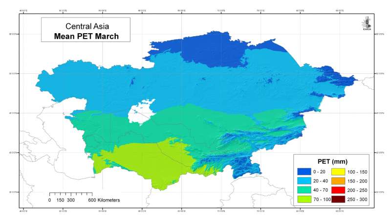
 March")
Central Asia: mean potential evapotranspiration (Penman-Monteith) March
Mean monthly potential evapotranspiration (PET) grid for Central Asia at 30 arc-second ( about 1 km) resolution: March
Metadataclose[x]
Central Asia: mean potential evapotranspiration (Penman-Monteith) March
Developed for geospatial applications that require location-specific information on atmospheric water requirements in places where no nearby climatic station exists
Mean monthly potential evapotranspiration (PET) grid for Central Asia at 30 arc-second ( about 1 km) resolution: March
International Center for Agricultural Research in the Dry Areas (ICARDA)
2008
climate, potential evapotranspiration, reference evapotranspiration, Penman-Monteith, Hargreaves, temperature
Central Asia, Tajikistan, Turkmenistan, Kazakhstan, Uzbekistan, Kyrgyzstan
46.491856
87.308524
55.424429
35.141094
D_WGS_1984
WGS_1984
6378137.000000
298.257224
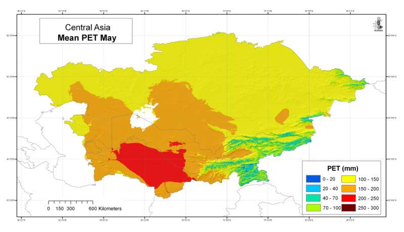
 May")
Central Asia: mean potential evapotranspiration (Penman-Monteith) May
Mean monthly potential evapotranspiration (PET) grid for Central Asia at 30 arc-second ( about 1 km) resolution: May
Metadataclose[x]
Central Asia: mean potential evapotranspiration (Penman-Monteith) May
Developed for geospatial applications that require location-specific information on atmospheric water requirements in places where no nearby climatic station exists
Mean monthly potential evapotranspiration (PET) grid for Central Asia at 30 arc-second ( about 1 km) resolution: May
International Center for Agricultural Research in the Dry Areas (ICARDA)
2008
climate, potential evapotranspiration, reference evapotranspiration, Penman-Monteith, Hargreaves, temperature
Central Asia, Tajikistan, Turkmenistan, Kazakhstan, Uzbekistan, Kyrgyzstan
46.491856
87.308524
55.424429
35.141094
D_WGS_1984
WGS_1984
6378137.000000
298.257224
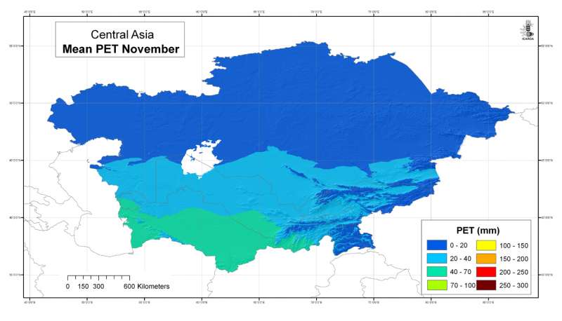
 November")
Central Asia: mean potential evapotranspiration (Penman-Monteith) November
Mean monthly potential evapotranspiration (PET) grid for Central Asia at 30 arc-second ( about 1 km) resolution: November
Metadataclose[x]
Central Asia: mean potential evapotranspiration (Penman-Monteith) November
Developed for geospatial applications that require location-specific information on atmospheric water requirements in places where no nearby climatic station exists
Mean monthly potential evapotranspiration (PET) grid for Central Asia at 30 arc-second ( about 1 km) resolution: November
International Center for Agricultural Research in the Dry Areas (ICARDA)
2008
climate, potential evapotranspiration, reference evapotranspiration, Penman-Monteith, Hargreaves, temperature
Central Asia, Tajikistan, Turkmenistan, Kazakhstan, Uzbekistan, Kyrgyzstan
46.491856
87.308524
55.424429
35.141094
D_WGS_1984
WGS_1984
6378137.000000
298.257224
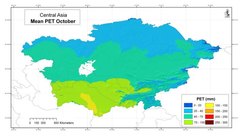
 October")
Central Asia: mean potential evapotranspiration (Penman-Monteith) October
Mean monthly potential evapotranspiration (PET) grid for Central Asia at 30 arc-second ( about 1 km) resolution: October
Metadataclose[x]
Central Asia: mean potential evapotranspiration (Penman-Monteith) October
Developed for geospatial applications that require location-specific information on atmospheric water requirements in places where no nearby climatic station exists
Mean monthly potential evapotranspiration (PET) grid for Central Asia at 30 arc-second ( about 1 km) resolution: October
International Center for Agricultural Research in the Dry Areas (ICARDA)
2008
climate, potential evapotranspiration, reference evapotranspiration, Penman-Monteith, Hargreaves, temperature
Central Asia, Tajikistan, Turkmenistan, Kazakhstan, Uzbekistan, Kyrgyzstan
46.491856
87.308524
55.424429
35.141094
D_WGS_1984
WGS_1984
6378137.000000
298.257224
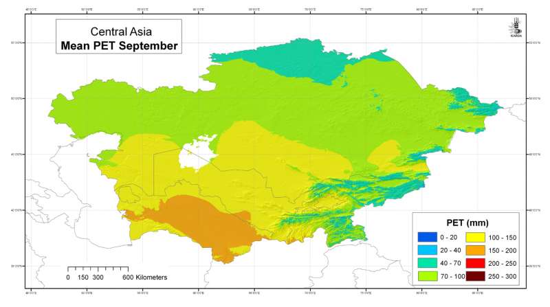
 September")
Central Asia: mean potential evapotranspiration (Penman-Monteith) September
Mean monthly potential evapotranspiration (PET) grid for Central Asia at 30 arc-second ( about 1 km) resolution: September
Metadataclose[x]
Central Asia: mean potential evapotranspiration (Penman-Monteith) September
Developed for geospatial applications that require location-specific information on atmospheric water requirements in places where no nearby climatic station exists
Mean monthly potential evapotranspiration (PET) grid for Central Asia at 30 arc-second ( about 1 km) resolution: September
International Center for Agricultural Research in the Dry Areas (ICARDA)
2008
climate, potential evapotranspiration, reference evapotranspiration, Penman-Monteith, Hargreaves, temperature
Central Asia, Tajikistan, Turkmenistan, Kazakhstan, Uzbekistan, Kyrgyzstan
46.491856
87.308524
55.424429
35.141094
D_WGS_1984
WGS_1984
6378137.000000
298.257224

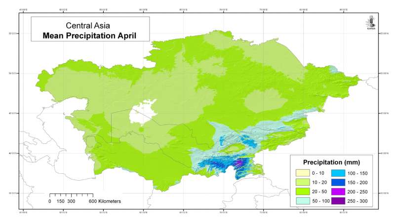
Central Asia: mean precipitation April
Mean monthly precipitation grid for Central Asia at 30 arc-second ( about 1 km) resolution: April
Metadataclose[x]
Central Asia: mean precipitation April
Developed for geospatial applications that require location-specific climatic information in places where no nearby climatic station exists
Mean monthly precipitation grid for Central Asia at 30 arc-second ( about 1 km) resolution: April
International Center for Agricultural Research in the Dry Areas (ICARDA)
2008
climate, precipitation
Central Asia, Tajikistan, Turkmenistan, Kazakhstan, Uzbekistan, Kyrgyzstan
46.491856
87.308524
55.424429
35.141094
D_WGS_1984
WGS_1984
6378137.000000
298.257224

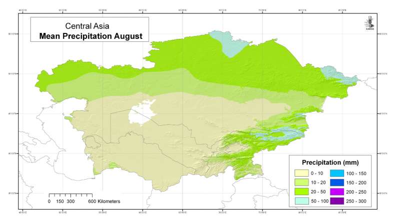
Central Asia: mean precipitation August
Mean monthly precipitation grid for Central Asia at 30 arc-second ( about 1 km) resolution: August
Metadataclose[x]
Central Asia: mean precipitation August
Developed for geospatial applications that require location-specific climatic information in places where no nearby climatic station exists
Mean monthly precipitation grid for Central Asia at 30 arc-second ( about 1 km) resolution: August
International Center for Agricultural Research in the Dry Areas (ICARDA)
2008
climate, precipitation
Central Asia, Tajikistan, Turkmenistan, Kazakhstan, Uzbekistan, Kyrgyzstan
46.491856
87.308524
55.424429
35.141094
D_WGS_1984
WGS_1984
6378137.000000
298.257224

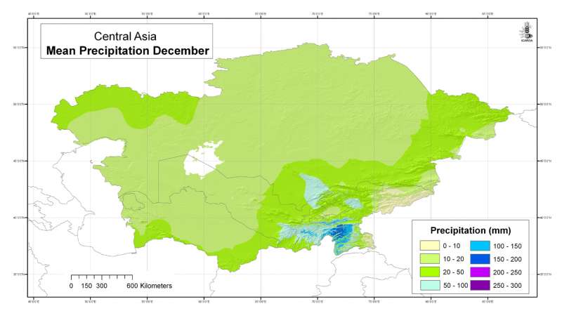
Central Asia: mean precipitation December
Mean monthly precipitation grid for Central Asia at 30 arc-second ( about 1 km) resolution: December
Metadataclose[x]
Central Asia: mean precipitation December
Developed for geospatial applications that require location-specific climatic information in places where no nearby climatic station exists
Mean monthly precipitation grid for Central Asia at 30 arc-second ( about 1 km) resolution: December
International Center for Agricultural Research in the Dry Areas (ICARDA)
2008
climate, precipitation
Central Asia, Tajikistan, Turkmenistan, Kazakhstan, Uzbekistan, Kyrgyzstan
46.491856
87.308524
55.424429
35.141094
D_WGS_1984
WGS_1984
6378137.000000
298.257224

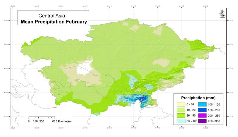
Central Asia: mean precipitation February
Mean monthly precipitation grid for Central Asia at 30 arc-second ( about 1 km) resolution: February
Metadataclose[x]
Central Asia: mean precipitation February
Developed for geospatial applications that require location-specific climatic information in places where no nearby climatic station exists
Mean monthly precipitation grid for Central Asia at 30 arc-second ( about 1 km) resolution: February
International Center for Agricultural Research in the Dry Areas (ICARDA)
2008
climate, precipitation
Central Asia, Tajikistan, Turkmenistan, Kazakhstan, Uzbekistan, Kyrgyzstan
46.491856
87.308524
55.424429
35.141094
D_WGS_1984
WGS_1984
6378137.000000
298.257224

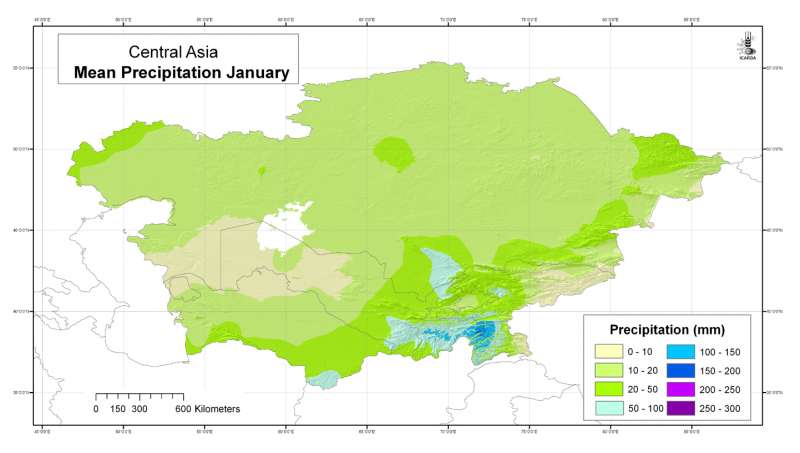
Central Asia: mean precipitation January
Mean monthly precipitation grid for Central Asia at 30 arc-second ( about 1 km) resolution: January
Metadataclose[x]
Central Asia: mean precipitation January
Developed for geospatial applications that require location-specific climatic information in places where no nearby climatic station exists
Mean monthly precipitation grid for Central Asia at 30 arc-second ( about 1 km) resolution: January
International Center for Agricultural Research in the Dry Areas (ICARDA)
2008
climate, precipitation
Central Asia, Tajikistan, Turkmenistan, Kazakhstan, Uzbekistan, Kyrgyzstan
46.491856
87.308524
55.424429
35.141094
D_WGS_1984
WGS_1984
6378137.000000
298.257224