


Geoinformatics Solutions for Integrated Agro-ecosystems Research
GIS Data
Maps in: CACILM

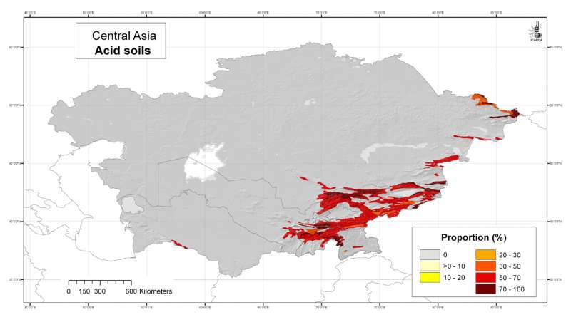
Central Asia: acid soils
Likelihood of the occurrence of acid soils in Central Asia at 30 arc-second ( about 1 km) resolution, derived from the FAO Soil Map of the World
Metadataclose[x]
Central Asia: acid soils
Derived soil properties give an indication of soil management properties and are useful for biodiversity assesment
Likelihood of the occurrence of acid soils in Central Asia at 30 arc-second ( about 1 km) resolution, derived from the FAO Soil Map of the World
International Center for Agricultural Research in the Dry Areas (ICARDA)
2008
soils, FAO, acid soils, soil pH
Central Asia, Tajikistan, Turkmenistan, Kazakhstan, Uzbekistan, Kyrgyzstan
46.491856
87.308524
55.432762
35.141094
D_WGS_1984
WGS_1984
6378137.000000
298.257224

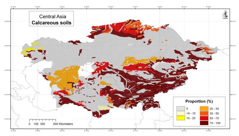
Central Asia: calcareous soils
Likelihood of the occurrence of calcareous (basic) soils in Central Asia at 30 arc-second ( about 1 km) resolution, derived from the FAO Soil Map of the World
Metadataclose[x]
Central Asia: calcareous soils
Derived soil properties give an indication of soil management properties and are useful for biodiversity assesment
Likelihood of the occurrence of calcareous (basic) soils in Central Asia at 30 arc-second ( about 1 km) resolution, derived from the FAO Soil Map of the World
International Center for Agricultural Research in the Dry Areas (ICARDA)
2008
soils, FAO, calcareous soils
Central Asia, Tajikistan, Turkmenistan, Kazakhstan, Uzbekistan, Kyrgyzstan
46.491856
87.308524
55.432762
35.141094
D_WGS_1984
WGS_1984
6378137.000000
298.257224

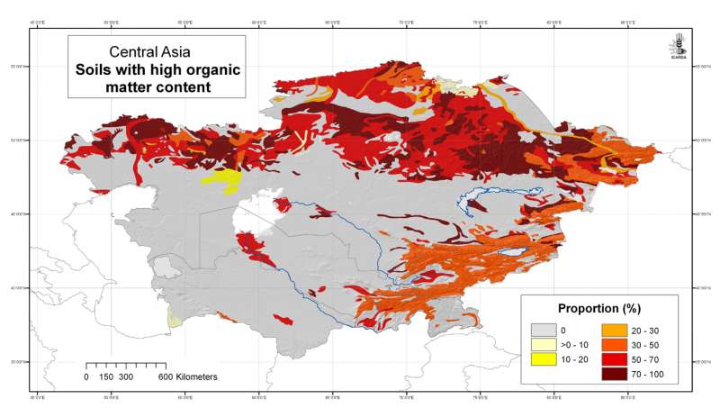
Central Asia: soils with high organic matter content
Likelihood of the occurrence of soils with high organic matter content in Central Asia at 30 arc-second ( about 1 km) resolution, derived from the FAO Soil Map of the World
Metadataclose[x]
Central Asia: soils with high organic matter content
Derived soil properties give an indication of soil management properties and are useful for biodiversity assesment
Likelihood of the occurrence of soils with high organic matter content in Central Asia at 30 arc-second ( about 1 km) resolution, derived from the FAO Soil Map of the World
International Center for Agricultural Research in the Dry Areas (ICARDA)
2008
soils, FAO, soil organic carbon, soil organic matter
Central Asia, Tajikistan, Turkmenistan, Kazakhstan, Uzbekistan, Kyrgyzstan
46.491856
87.308524
55.432762
35.141094
D_WGS_1984
WGS_1984
6378137.000000
298.257224

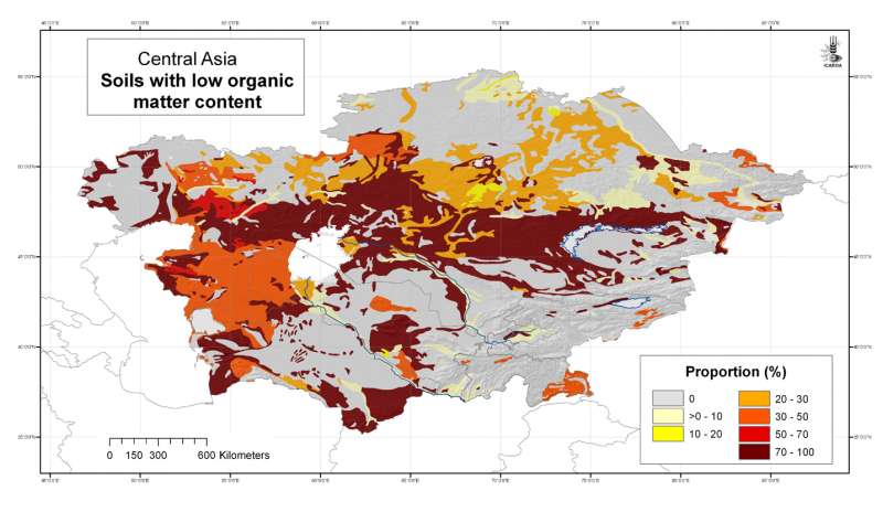
Central Asia: soils with low organic matter content
Likelihood of the occurrence of soils with low organic matter content in Central Asia at 30 arc-second ( about 1 km) resolution, derived from the FAO Soil Map of the World
Metadataclose[x]
Central Asia: soils with low organic matter content
Derived soil properties give an indication of soil management properties and are useful for biodiversity assesment
Likelihood of the occurrence of soils with low organic matter content in Central Asia at 30 arc-second ( about 1 km) resolution, derived from the FAO Soil Map of the World
International Center for Agricultural Research in the Dry Areas (ICARDA)
2008
soils, FAO, soil organic carbon, soil organic matter
Central Asia, Tajikistan, Turkmenistan, Kazakhstan, Uzbekistan, Kyrgyzstan
46.491856
87.308524
55.432762
35.141094
D_WGS_1984
WGS_1984
6378137.000000
298.257224

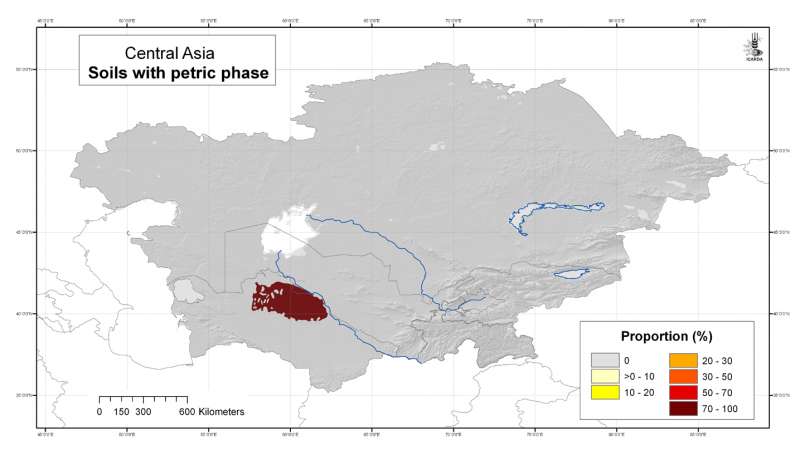
Central Asia: indurated soils with petric phase
Likelihood of the occurrence of soils with a petric phase in Central Asia at 30 arc-second ( about 1 km) resolution, derived from the FAO Soil Map of the World
Metadataclose[x]
Central Asia: indurated soils with petric phase
Derived soil properties give an indication of soil management properties and are useful for biodiversity assesment
Likelihood of the occurrence of soils with a petric phase in Central Asia at 30 arc-second ( about 1 km) resolution, derived from the FAO Soil Map of the World
International Center for Agricultural Research in the Dry Areas (ICARDA)
2008
soils, FAO, indurated soils, ironstone, petric phase, plinthite
Central Asia, Tajikistan, Turkmenistan, Kazakhstan, Uzbekistan, Kyrgyzstan
46.491856
87.308524
55.432762
35.141094
D_WGS_1984
WGS_1984
6378137.000000
298.257224

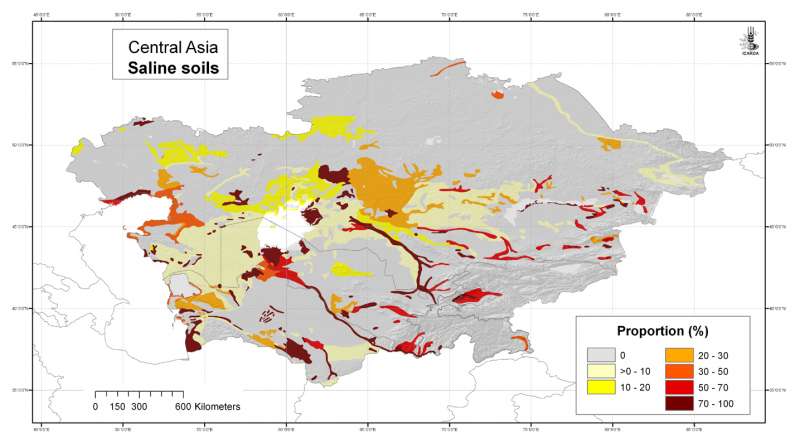
Central Asia: saline soils
Likelihood of the occurrence of saline soils in Central Asia at 30 arc-second ( about 1 km) resolution, derived from the FAO Soil Map of the World
Metadataclose[x]
Central Asia: saline soils
Derived soil properties give an indication of soil management properties and are useful for biodiversity assesment
Likelihood of the occurrence of saline soils in Central Asia at 30 arc-second ( about 1 km) resolution, derived from the FAO Soil Map of the World
International Center for Agricultural Research in the Dry Areas (ICARDA)
2008
soils, FAO, saline soils
Central Asia, Tajikistan, Turkmenistan, Kazakhstan, Uzbekistan, Kyrgyzstan
46.491860
87.308530
55.432758
35.141090
D_WGS_1984
WGS_1984
6378137.000000
298.257224

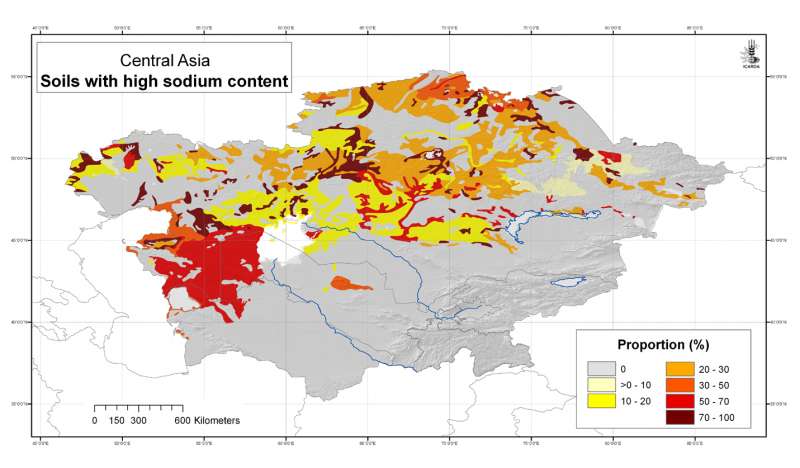
Central Asia: soils with high sodium content
Likelihood of the occurrence of soils with high sodium content in Central Asia at 30 arc-second ( about 1 km) resolution, derived from the FAO Soil Map of the World
Metadataclose[x]
Central Asia: soils with high sodium content
Derived soil properties give an indication of soil management properties and are useful for biodiversity assesment
Likelihood of the occurrence of soils with high sodium content in Central Asia at 30 arc-second ( about 1 km) resolution, derived from the FAO Soil Map of the World
International Center for Agricultural Research in the Dry Areas (ICARDA)
2008
soils, FAO, sodic soils, sodium
Central Asia, Tajikistan, Turkmenistan, Kazakhstan, Uzbekistan, Kyrgyzstan
46.491856
87.308524
55.432762
35.141094
D_WGS_1984
WGS_1984
6378137.000000
298.257224

Central Asia: soil management domains
Soil management domains in Central Asia at 30 arc-second ( about 1 km) resolution, derived from the FAO Soil Map of the World
Metadataclose[x]
Central Asia: soil management domains
Derived soil properties give an indication of soil management properties and are useful for biodiversity assesment
Soil management domains in Central Asia at 30 arc-second ( about 1 km) resolution, derived from the FAO Soil Map of the World
International Center for Agricultural Research in the Dry Areas (ICARDA)
2008
soils, FAO, soil management
Central Asia, Tajikistan, Turkmenistan, Kazakhstan, Uzbekistan, Kyrgyzstan
46.491856
87.308524
55.432762
35.141094
D_WGS_1984
WGS_1984
6378137.000000
298.257224

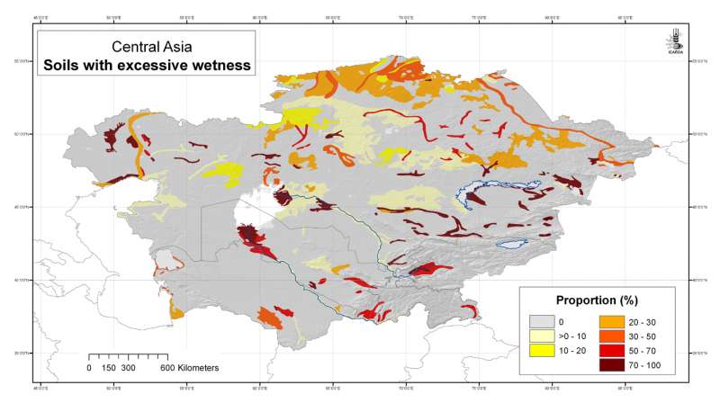
Central Asia: poorly drained and wetland soils
Likelihood of the occurrence of poorly drained and wetland soils in Central Asia at 30 arc-second ( about 1 km) resolution, derived from the FAO Soil Map of the World
Metadataclose[x]
Central Asia: poorly drained and wetland soils
Derived soil properties give an indication of soil management properties and are useful for biodiversity assesment
Likelihood of the occurrence of poorly drained and wetland soils in Central Asia at 30 arc-second ( about 1 km) resolution, derived from the FAO Soil Map of the World
International Center for Agricultural Research in the Dry Areas (ICARDA)
2008
soils, FAO, wetland soils, drainage
Central Asia, Tajikistan, Turkmenistan, Kazakhstan, Uzbekistan, Kyrgyzstan
46.491856
87.308524
55.432762
35.141094
D_WGS_1984
WGS_1984
6378137.000000
298.257224

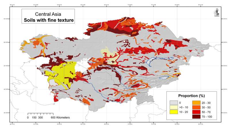
Central Asia: soils with fine texture
Likelihood of the occurrence of clayey soils in Central Asia at 30 arc-second ( about 1 km) resolution, derived from the FAO Soil Map of the World
Metadataclose[x]
Central Asia: soils with fine texture
Derived soil properties give an indication of soil management properties and are useful for biodiversity assesment
Likelihood of the occurrence of clayey soils in Central Asia at 30 arc-second ( about 1 km) resolution, derived from the FAO Soil Map of the World
International Center for Agricultural Research in the Dry Areas (ICARDA)
2008
soils, FAO, clayey soils, soil texture
Central Asia, Tajikistan, Turkmenistan, Kazakhstan, Uzbekistan, Kyrgyzstan
46.491856
87.308524
55.432762
35.141094
D_WGS_1984
WGS_1984
6378137.000000
298.257224

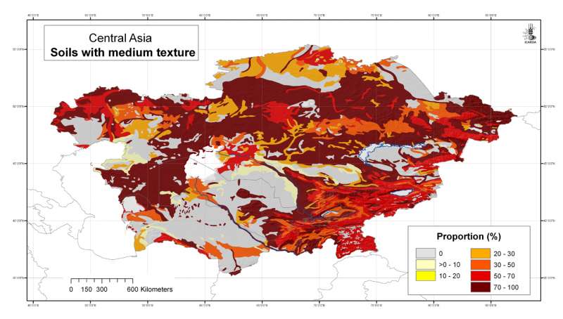
Central Asia: soils with medium texture
Likelihood of the occurrence of medium-textured soils in Central Asia at 30 arc-second ( about 1 km) resolution, derived from the FAO Soil Map of the World
Metadataclose[x]
Central Asia: soils with medium texture
Derived soil properties give an indication of soil management properties and are useful for biodiversity assesment
Likelihood of the occurrence of medium-textured soils in Central Asia at 30 arc-second ( about 1 km) resolution, derived from the FAO Soil Map of the World
International Center for Agricultural Research in the Dry Areas (ICARDA)
2008
soils, FAO, loamy soils, soil texture
Central Asia, Tajikistan, Turkmenistan, Kazakhstan, Uzbekistan, Kyrgyzstan
46.491856
87.308524
55.432762
35.141094
D_WGS_1984
WGS_1984
6378137.000000
298.257224

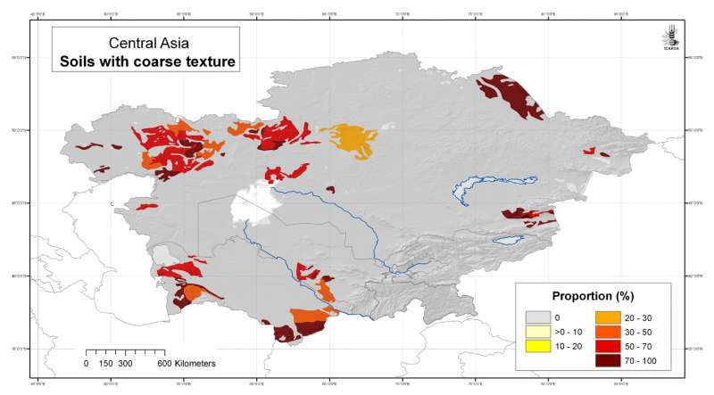
Central Asia: sandy soils
Likelihood of the occurrence of sandy soils in Central Asia at 30 arc-second ( about 1 km) resolution, derived from the FAO Soil Map of the World
Metadataclose[x]
Central Asia: sandy soils
Derived soil properties give an indication of soil management properties and are useful for biodiversity assesment
Likelihood of the occurrence of sandy soils in Central Asia at 30 arc-second ( about 1 km) resolution, derived from the FAO Soil Map of the World
International Center for Agricultural Research in the Dry Areas (ICARDA)
2008
soils, FAO, clayey soils, soil texture
Central Asia, Tajikistan, Turkmenistan, Kazakhstan, Uzbekistan, Kyrgyzstan
46.491856
87.308524
55.432762
35.141094
D_WGS_1984
WGS_1984
6378137.000000
298.257224

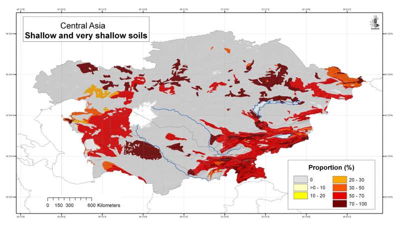
Central Asia: shallow and very shallow soils
Likelihood of the occurrence of shallow soils in Central Asia at 30 arc-second ( about 1 km) resolution, derived from the FAO Soil Map of the World
Metadataclose[x]
Central Asia: shallow and very shallow soils
Derived soil properties give an indication of soil management properties and are useful for biodiversity assesment
Likelihood of the occurrence of shallow soils in Central Asia at 30 arc-second ( about 1 km) resolution, derived from the FAO Soil Map of the World
International Center for Agricultural Research in the Dry Areas (ICARDA)
2008
soils, FAO, shallow soils
Central Asia, Tajikistan, Turkmenistan, Kazakhstan, Uzbekistan, Kyrgyzstan
46.491856
87.308524
55.432762
35.141094
D_WGS_1984
WGS_1984
6378137.000000
298.257224
")
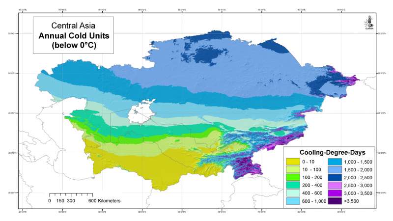
Central Asia: Annual Cold Units (below 0���������������°C)
Annual Cold Units grid for Central Asia at 30 arc-second ( about 1 km) resolution
Metadataclose[x]
Central Asia: Annual Cold Units (below 0���������������°C)
Developed for geospatial applications that require location-specific climatic information in places where no nearby climatic station exists
Annual Cold Units grid for Central Asia at 30 arc-second ( about 1 km) resolution
International Center for Agricultural Research in the Dry Areas (ICARDA)
2008
climate, temperature, cooling degree days
Central Asia, Tajikistan, Turkmenistan, Kazakhstan, Uzbekistan, Kyrgyzstan
46.491856
87.315223
55.431949
35.141094
D_WGS_1984
WGS_1984
6378137.000000
298.257224
")
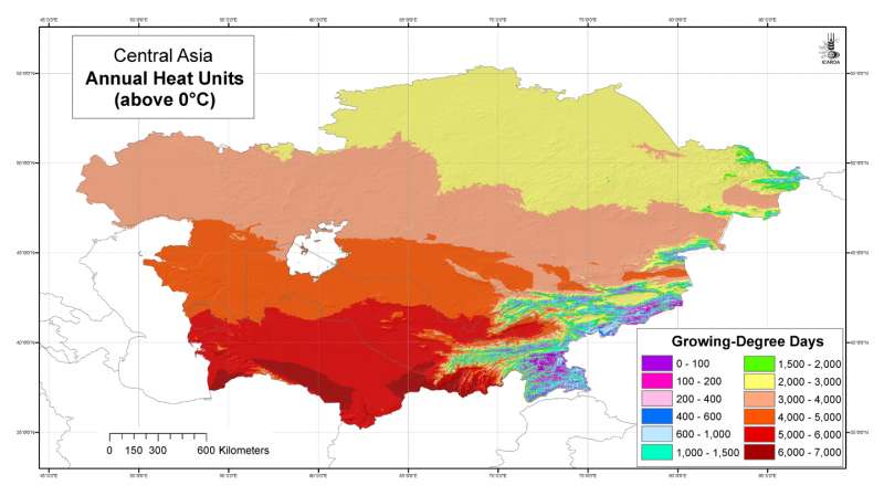
Central Asia: Annual Heat Units (above 0���������������°C)
Annual Heat Units grid for Central Asia at 30 arc-second ( about 1 km) resolution
Metadataclose[x]
Central Asia: Annual Heat Units (above 0���������������°C)
Developed for geospatial applications that require location-specific climatic information in places where no nearby climatic station exists
Annual Heat Units grid for Central Asia at 30 arc-second ( about 1 km) resolution
International Center for Agricultural Research in the Dry Areas (ICARDA)
2008
climate, temperature, heat units, growing degree days
Central Asia, Tajikistan, Turkmenistan, Kazakhstan, Uzbekistan, Kyrgyzstan
46.491856
87.315223
55.431949
35.141094
D_WGS_1984
WGS_1984
6378137.000000
298.257224

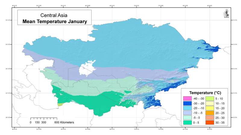
Central Asia: mean temperature January
Mean temperature grid for Central Asia at 30 arc-second ( about 1 km) resolution: January
Metadataclose[x]
Central Asia: mean temperature January
Developed for geospatial applications that require location-specific climatic information in places where no nearby climatic station exists
Mean temperature grid for Central Asia at 30 arc-second ( about 1 km) resolution: January
International Center for Agricultural Research in the Dry Areas (ICARDA)
2008
climate, temperature
Central Asia, Tajikistan, Turkmenistan, Kazakhstan, Uzbekistan, Kyrgyzstan
46.491856
87.308524
55.424429
35.141094
D_WGS_1984
WGS_1984
6378137.000000
298.257224

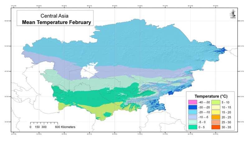
Central Asia: mean temperature February
Mean temperature grid for Central Asia at 30 arc-second ( about 1 km) resolution: February
Metadataclose[x]
Central Asia: mean temperature February
Developed for geospatial applications that require location-specific climatic information in places where no nearby climatic station exists
Mean temperature grid for Central Asia at 30 arc-second ( about 1 km) resolution: February
International Center for Agricultural Research in the Dry Areas (ICARDA)
2008
climate, temperature
Central Asia, Tajikistan, Turkmenistan, Kazakhstan, Uzbekistan, Kyrgyzstan
46.491856
87.308524
55.424429
35.141094
D_WGS_1984
WGS_1984
6378137.000000
298.257224

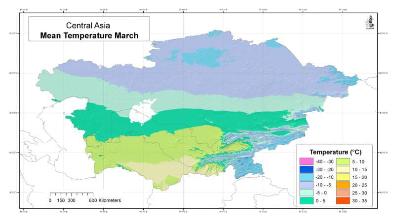
Central Asia: mean temperature March
Mean temperature grid for Central Asia at 30 arc-second ( about 1 km) resolution: March
Metadataclose[x]
Central Asia: mean temperature March
Developed for geospatial applications that require location-specific climatic information in places where no nearby climatic station exists
Mean temperature grid for Central Asia at 30 arc-second ( about 1 km) resolution: March
International Center for Agricultural Research in the Dry Areas (ICARDA)
2008
climate, temperature
Central Asia, Tajikistan, Turkmenistan, Kazakhstan, Uzbekistan, Kyrgyzstan
46.491856
87.308524
55.424429
35.141094
D_WGS_1984
WGS_1984
6378137.000000
298.257224

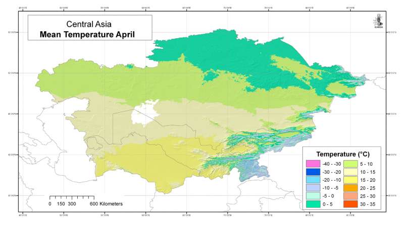
Central Asia: mean temperature April
Mean temperature grid for Central Asia at 30 arc-second ( about 1 km) resolution: April
Metadataclose[x]
Central Asia: mean temperature April
Developed for geospatial applications that require location-specific climatic information in places where no nearby climatic station exists
Mean temperature grid for Central Asia at 30 arc-second ( about 1 km) resolution: April
International Center for Agricultural Research in the Dry Areas (ICARDA)
2008
climate, temperature
Central Asia, Tajikistan, Turkmenistan, Kazakhstan, Uzbekistan, Kyrgyzstan
46.491856
87.308524
55.424429
35.141094
D_WGS_1984
WGS_1984
6378137.000000
298.257224

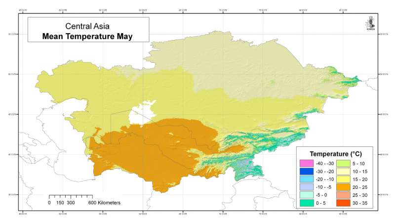
Central Asia: mean temperature May
Mean temperature grid for Central Asia at 30 arc-second ( about 1 km) resolution: May
Metadataclose[x]
Central Asia: mean temperature May
Developed for geospatial applications that require location-specific climatic information in places where no nearby climatic station exists
Mean temperature grid for Central Asia at 30 arc-second ( about 1 km) resolution: May
International Center for Agricultural Research in the Dry Areas (ICARDA)
2008
climate, temperature
Central Asia, Tajikistan, Turkmenistan, Kazakhstan, Uzbekistan, Kyrgyzstan
46.491856
87.308524
55.424429
35.141094
D_WGS_1984
WGS_1984
6378137.000000
298.257224

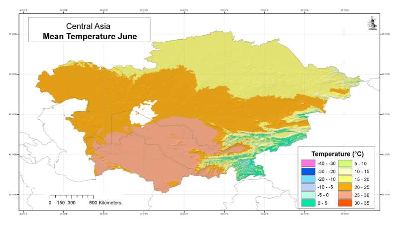
Central Asia: mean temperature June
Mean temperature grid for Central Asia at 30 arc-second ( about 1 km) resolution: June
Metadataclose[x]
Central Asia: mean temperature June
Developed for geospatial applications that require location-specific climatic information in places where no nearby climatic station exists
Mean temperature grid for Central Asia at 30 arc-second ( about 1 km) resolution: June
International Center for Agricultural Research in the Dry Areas (ICARDA)
2008
climate, temperature
Central Asia, Tajikistan, Turkmenistan, Kazakhstan, Uzbekistan, Kyrgyzstan
46.491856
87.308524
55.424429
35.141094
D_WGS_1984
WGS_1984
6378137.000000
298.257224

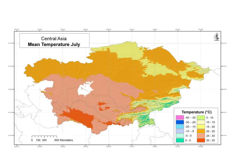
Central Asia: mean temperature July
Mean temperature grid for Central Asia at 30 arc-second ( about 1 km) resolution: July
Metadataclose[x]
Central Asia: mean temperature July
Developed for geospatial applications that require location-specific climatic information in places where no nearby climatic station exists
Mean temperature grid for Central Asia at 30 arc-second ( about 1 km) resolution: July
International Center for Agricultural Research in the Dry Areas (ICARDA)
2008
climate, temperature
Central Asia, Tajikistan, Turkmenistan, Kazakhstan, Uzbekistan, Kyrgyzstan
46.491856
87.308524
55.424429
35.141094
D_WGS_1984
WGS_1984
6378137.000000
298.257224

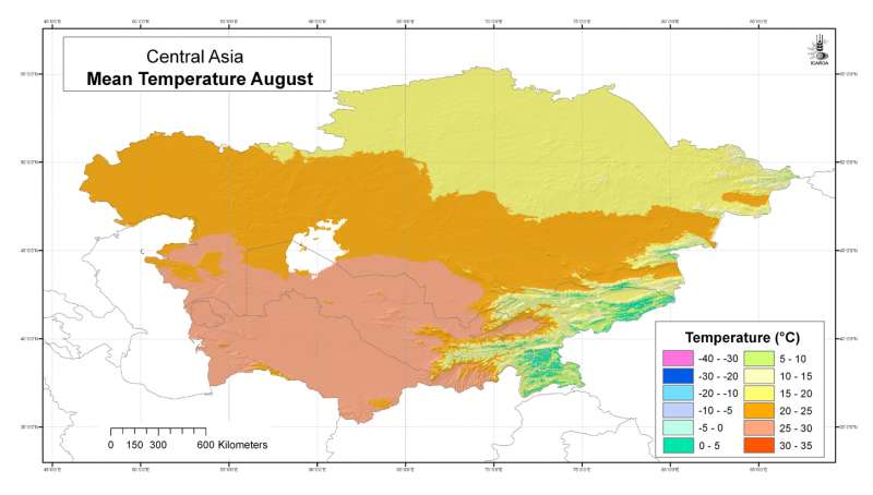
Central Asia: mean temperature August
Mean temperature grid for Central Asia at 30 arc-second ( about 1 km) resolution: August
Metadataclose[x]
Central Asia: mean temperature August
Developed for geospatial applications that require location-specific climatic information in places where no nearby climatic station exists
Mean temperature grid for Central Asia at 30 arc-second ( about 1 km) resolution: August
International Center for Agricultural Research in the Dry Areas (ICARDA)
2008
climate, temperature
Central Asia, Tajikistan, Turkmenistan, Kazakhstan, Uzbekistan, Kyrgyzstan
46.491856
87.308524
55.424429
35.141094
D_WGS_1984
WGS_1984
6378137.000000
298.257224

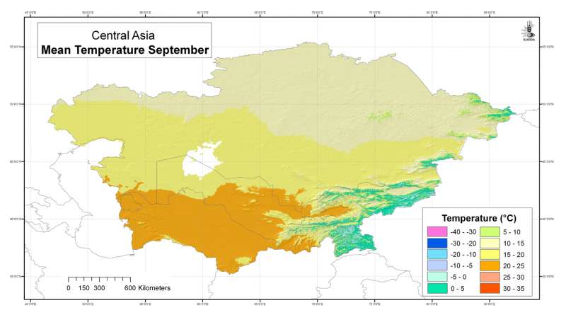
Central Asia: mean temperature September
Mean temperature grid for Central Asia at 30 arc-second ( about 1 km) resolution: September
Metadataclose[x]
Central Asia: mean temperature September
Developed for geospatial applications that require location-specific climatic information in places where no nearby climatic station exists
Mean temperature grid for Central Asia at 30 arc-second ( about 1 km) resolution: September
International Center for Agricultural Research in the Dry Areas (ICARDA)
2008
climate, temperature
Central Asia, Tajikistan, Turkmenistan, Kazakhstan, Uzbekistan, Kyrgyzstan
46.491856
87.308524
55.424429
35.141094
D_WGS_1984
WGS_1984
6378137.000000
298.257224

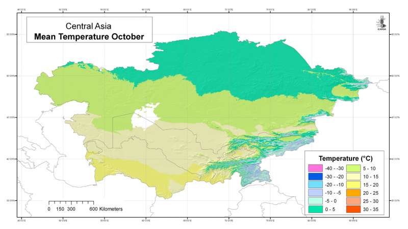
Central Asia: mean temperature October
Mean temperature grid for Central Asia at 30 arc-second ( about 1 km) resolution: October
Metadataclose[x]
Central Asia: mean temperature October
Developed for geospatial applications that require location-specific climatic information in places where no nearby climatic station exists
Mean temperature grid for Central Asia at 30 arc-second ( about 1 km) resolution: October
International Center for Agricultural Research in the Dry Areas (ICARDA)
2008
climate, temperature
Central Asia, Tajikistan, Turkmenistan, Kazakhstan, Uzbekistan, Kyrgyzstan
46.491856
87.308524
55.424429
35.141094
D_WGS_1984
WGS_1984
6378137.000000
298.257224